- Home
- :
- All Communities
- :
- Developers
- :
- Python
- :
- Python Questions
- :
- Problem With lry.refreshDataSource
- Subscribe to RSS Feed
- Mark Topic as New
- Mark Topic as Read
- Float this Topic for Current User
- Bookmark
- Subscribe
- Mute
- Printer Friendly Page
- Mark as New
- Bookmark
- Subscribe
- Mute
- Subscribe to RSS Feed
- Permalink
Good day everyone,
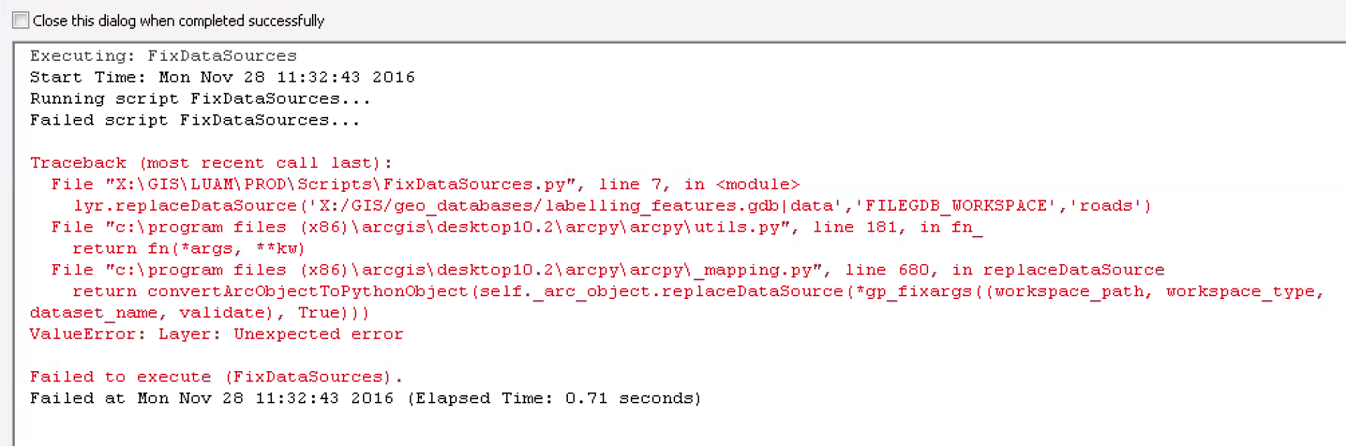
I am playing around with the following code to fix broken data sources for file gedatabases. There's something I am getting wrong in it and I am getting the following error messages displayed. If anyone can point out what I'm doing wrong I would greatly appreciate it.
Thanks very much,
Chris
import arcpy mxd = arcpy.mapping.MapDocument("CURRENT") for lyr in arcpy.mapping.ListLayers(mxd): if lyr.name == 'roads': lyr.replaceDataSource('X:/GIS/geo_databases/labelling_features.gdb|data','FILEGDB_WORKSPACE','roads') elif lyr.name == 'railways': lyr.replaceDataSource('X:/GIS/geo_databases/labelling_features.gdb|data','FILEGDB_WORKSPACE','railways') elif lyr.name == 'rivers': lyr.replaceDataSource('X:/GIS/geo_databases/labelling_features.gdb|data','FILEGDB_WORKSPACE','rivers') elif lyr.name == 'lakes': lyr.replaceDataSource('X:/GIS/geo_databases/labelling_features.gdb|data','FILEGDB_WORKSPACE','lakes') elif lyr.name == 'bridge_polygons': lyr.replaceDataSource('X:/GIS/geo_databases/planning_data.gdb|data','FILEGDB_WORKSPACE','bridge_polygons') del mxd Result = True arcpy.SetParameterAsText(0,Result)
Solved! Go to Solution.
Accepted Solutions
- Mark as New
- Bookmark
- Subscribe
- Mute
- Subscribe to RSS Feed
- Permalink
Just a guess, without looking at it in detail a couple observations....
- do you need to save the mxd before you delete it?
- why is there a pipe ( | ) in your argument?
You may want to look at the samples near the end of this help doc
Updating and fixing data sources with arcpy.mapping—Help | ArcGIS for Desktop
- Mark as New
- Bookmark
- Subscribe
- Mute
- Subscribe to RSS Feed
- Permalink
Hi Rebecca,
1. I added in mxd.save, makes no difference to the error.
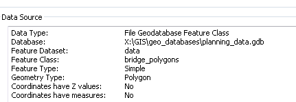
2. The pipe, I believe indicates that 'data' is a feature dataset in the file geodatabase. I have used it successfully in other scripts, but not sure if it works for this instance?
Hopefully this helps provide a bit more info.
thanks
- Mark as New
- Bookmark
- Subscribe
- Mute
- Subscribe to RSS Feed
- Permalink
This path doesn't seem right to me:
X:/GIS/geo_databases/labelling_features.gdb|data
Do you mean to put '/' instead of '|'?
X:/GIS/geo_databases/labelling_features.gdb/data
- Mark as New
- Bookmark
- Subscribe
- Mute
- Subscribe to RSS Feed
- Permalink
In the link provided by Rebecca: http://desktop.arcgis.com/en/arcmap/10.3/analyze/arcpy-mapping/updatingandfixingdatasources.htm#ESRI...
I read:
Do not include the names of geodatabase feature datasets in the workspace path. Feature datasets are part of the workspace. If a feature class, for example, is moved from being a stand-alone feature class into a geodatabase feature dataset, a map document will still open without the layer being broken.
So I removed the reference to the feature datasets in each workspace "|data".
The script works now, but it doesn't do anything. lol
I'll have to recheck the parameters I'm using.
- Mark as New
- Bookmark
- Subscribe
- Mute
- Subscribe to RSS Feed
- Permalink
I figured it out. I needed to add arcpy.RefreshTOC(). duh. I'll give the correct answer to Rebecca as she got me onto the path of getting this working. Funny that I had previously looked at that link just didn't see the item about the feature datasets. Thanks also for your suggestions Mitch.
Here is the finished working script:
import arcpy
mxd = arcpy.mapping.MapDocument("CURRENT")
for lyr in arcpy.mapping.ListLayers(mxd):
if lyr.name == 'roads':
lyr.replaceDataSource(r"X:\GIS\geo_databases\labelling_features.gdb","FILEGDB_WORKSPACE","roads")
if lyr.name == 'railways':
lyr.replaceDataSource('X:/GIS/geo_databases/labelling_features.gdb','FILEGDB_WORKSPACE','railways')
elif lyr.name == 'rivers':
lyr.replaceDataSource('X:/GIS/geo_databases/labelling_features.gdb','FILEGDB_WORKSPACE','rivers')
elif lyr.name == 'lakes':
lyr.replaceDataSource('X:/GIS/geo_databases/labelling_features.gdb','FILEGDB_WORKSPACE','lakes')
elif lyr.name == 'bridge_polygons':
lyr.replaceDataSource('X:/GIS/geo_databases/planning_data.gdb','FILEGDB_WORKSPACE','bridge_polygons')
arcpy.RefreshTOC()
mxd.save
del mxd
Result = True
arcpy.SetParameterAsText(0,Result)