Turn on suggestions
Auto-suggest helps you quickly narrow down your search results by suggesting possible matches as you type.
Cancel
- Home
- :
- All Communities
- :
- Developers
- :
- Python
- :
- Python Questions
- :
- Point geometry to feature class?
Options
- Subscribe to RSS Feed
- Mark Topic as New
- Mark Topic as Read
- Float this Topic for Current User
- Bookmark
- Subscribe
- Mute
- Printer Friendly Page
Point geometry to feature class?
Subscribe
1195
2
08-01-2017 07:02 AM
08-01-2017
07:02 AM
- Mark as New
- Bookmark
- Subscribe
- Mute
- Subscribe to RSS Feed
- Permalink
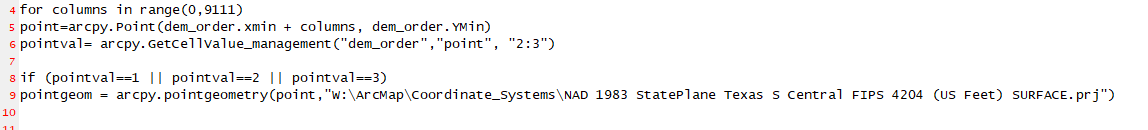
I am trying to take a point in a xy coordinate and putting a gis coordinate with it. Now I am taking the pointgeometry and creating a feature class or a shapefile. What is the function for this? and how can I make it have unique file names after every loop?
2 Replies
08-01-2017
08:25 AM
- Mark as New
- Bookmark
- Subscribe
- Mute
- Subscribe to RSS Feed
- Permalink
Python is very picky about spacing, and their should be a ":" after your for and if statements, with the next lines indented. Correct that and repost your code using https://community.esri.com/people/curtvprice/blog/2014/09/25/posting-code-blocks-in-the-new-geonet?s...
08-01-2017
02:25 PM
- Mark as New
- Bookmark
- Subscribe
- Mute
- Subscribe to RSS Feed
- Permalink
In one of your other threads... Copy Features was recommended. Posting in one location makes it easier for people to keep track of a question and its incarnations.