- Home
- :
- All Communities
- :
- Developers
- :
- Python
- :
- Python Questions
- :
- Path Distance erratic and crashes in a loop
- Subscribe to RSS Feed
- Mark Topic as New
- Mark Topic as Read
- Float this Topic for Current User
- Bookmark
- Subscribe
- Mute
- Printer Friendly Page
Path Distance erratic and crashes in a loop
- Mark as New
- Bookmark
- Subscribe
- Mute
- Subscribe to RSS Feed
- Permalink
Hi,
I am using arcgis 10.5.1 64 bit.
I have a set of 10 point features that I am trying to connect using PathDistance. Each point has an id, say 0...9. Effectively I want to generate the path from 0 to 1, 1 to 2, and so on.
I am using both my own tables to define vertical and horizontal factors. I have created these paths manually using the exact same factors. So I know those work.
The two main files I am using are: 1) a sample DEM (5m resolution, tif) called test_dem.tif 2) a point shapefile test_loc.shp which contains 11 points with several columns but the main one used here is 'Id' column. These files and others used for the script can be found below.
The files used for the vertical and horizontal factors are the following,
| hsine.txt | vertical3.txt |
|---|---|
0 1 | -90 20000 -80 5000 -70 1500 -60 300 -50 100 -40 40 -30 12 -20 3 -10 1 0 3 10 7 20 14 30 24 40 40 50 75 60 180 70 750 80 1500 90 5000 |
I have the following code:
import arcpy
import arcpy.sa as sa
import arcpy.management as mng
from math import pi
# Checking out SA extension
class SAerror(Exception):
pass
try:
if arcpy.CheckExtension('Spatial') == 'Available':
arcpy.CheckOutExtension('Spatial')
else:
raise SAerror
except SAerror:
print('Spatial Analyst license is unavailable!')
except arcpy.ExecuteError:
print(arcpy.GetMessages(2))
# ArcGIS directories
arcpy.env.scratchWorkspace = r'C:\GIS\projects\network\potential\SCRATCH'
arcpy.env.workspace = r'C:\GIS\projects\network\potential'
# input rasters
rDEM = arcpy.Raster(r'C:\GIS\projects\network\potential\tst_dem.tif')
shpFeat = r'C:\GIS\projects\network\potential\testloc.shp'
# PARAMETERS
deg2rad = pi/180.0
rad2deg = 180.0/pi
wFactor = 0.2
I = 4.0
wPthPot = 0.75
Gmax = 5.0
# path distance parameters
rCost = "" # use unit
rSurface = rDEM
rVertical = rDEM
hCostfn = r'C:\GIS\projects\network\potential\hsine.txt'
HF = sa.HfTable(hCostfn)
vCostfn = r'C:\GIS\projects\network\potential\vertical3.txt'
VF = sa.VfTable(vCostfn)
maxDist = ""
nbrfn = r'C:\GIS\projects\network\potential\expd.txt'
#Set geoprocessing environmental preferences
arcpy.env.extent = rDEM.extent
arcpy.env.cellSize = rDEM.meanCellHeight
arcpy.env.overwriteOutput= True
# INITIAL CONDITIONS
rTPot = rDEM / rDEM.maximum
rDirRel = rTPot
rG0 = sa.CreateConstantRaster(0.0, 'FLOAT', arcpy.env.cellSize, arcpy.env.extent)
rGmax = sa.CreateConstantRaster(Gmax, 'FLOAT', arcpy.env.cellSize, arcpy.env.extent)
rGt_1 = sa.CreateConstantRaster(0.0, 'FLOAT', arcpy.env.cellSize, arcpy.env.extent)
# sample sequence
pthseq = list(range(11))
# create a feature layer
mng.MakeFeatureLayer(shpFeat, 'lyr')
# MAIN
for o,d in zip(pthseq[:-1], pthseq[1:]):
# lambda direction
rDir = sa.Aspect(rDirRel)
# CALCULATE PATH
mng.SelectLayerByAttribute('lyr', "NEW_SELECTION", ' "Id" = '+str(o)) # origin
# accumulated cost surface
rAcs= sa.PathDistance('lyr', "", rSurface, rDir, HF, rVertical, VF, "", 'rBL.tif')
mng.SelectLayerByAttribute('lyr', "NEW_SELECTION", ' "Id" = '+str(d)) # destination
# path
rPath = sa.CostPath('lyr', rAcs, 'rBL.tif', "EACH_CELL")
rPath = sa.Con(sa.IsNull(rPath), 0, 1)
pathFn = 'path'+str(o)+'_'+str(d)+'.tif'
rPath.save(pathFn)
rW = (rG0 - rGt_1) * wFactor
rMark = rPath * (1.0 - (rGt_1 / rGmax)) * I
rGt = rGt_1 + rW + rMark
rGt.save('rGt.tif')
# DECAY
rPthPot = sa.FocalStatistics(rGt, sa.NbrWeight(nbrfn),'SUM')
rPthPot = rPthPot.maximum - rPthPot
rPthPot = rPthPot / rPthPot.maximum
# Update directional relation
rDirRel = rPthPot * wPthPot + rTPot * (1.0 - wPthPot)
# Update rGt_1 *** missing earlier ***
rGt_1 = rGtOverall, I get very weird behavior. Some times, it will fail when trying to generate the backlink. In other occasions, it will calculate the first path and then fail. It will calculate three paths and fail. Only once it has ran through the entire sequence. After crashing I make sure to delete all possible files (usually the backlink file is created but it is corrupted).
I have tried many things:
1. Creating a fresh feature layer and erasing it at the end of each iteration.
2. Generating with each iteration different feature layers, one for the origin and another for the destination, and deleting them after each iteration.
3. I have tried saving to the disk the layer feature as well as all the other rasters (I set arcpy to overwrite).
4. I have tried saving to the disk the backlink
5. I have used relative and absolute filenames.
6. I am using only .tif files
7. I have use try...except to catch information about the error with no success
I have spent much time reading through the different forums, etc. I know there were problems with this method in previous iterations of the software. The lack of any feedback relating to possible errors is a real problem! Often it will be python that crashes all together. It is very finicky, there are certain Horizontal Factor settings (even those found in the help pages) that will not generate a complete cost accumulation raster. This is not my case though.
My question is whether there is something that I am missing, something that needs to be reset or deleted? or perhaps someone can suggest how to find more information after the procedure fails???
thank you,
Marc
- Mark as New
- Bookmark
- Subscribe
- Mute
- Subscribe to RSS Feed
- Permalink
Thanks Xander... I will repost with all the script and the data. keep tuned
- Mark as New
- Bookmark
- Subscribe
- Mute
- Subscribe to RSS Feed
- Permalink
Just reposted the script.
- Mark as New
- Bookmark
- Subscribe
- Mute
- Subscribe to RSS Feed
- Permalink
Hi Marcos Llobera ,
Thanks for sharing the code, that helps, but I am wondering... is this really the code you used? I'm asking since lines 11, 12 and 13 are missing an indentation and line 80 still has a space between "sa." and "CostPath".
It will really be necessary to have access to the data you are using, in the first place to help understand the code and in the second place to see if strange behavior might be related to the data.It is weird though that running the same code on the same data has different results (crashes).
Dan Patterson , don't go, you will miss out on all the fun. 
- Mark as New
- Bookmark
- Subscribe
- Mute
- Subscribe to RSS Feed
- Permalink
And, please a full description of the input Dem. Is it in projected space?
- Mark as New
- Bookmark
- Subscribe
- Mute
- Subscribe to RSS Feed
- Permalink
Found how to post the data. So, you should have everything to run. Let me know if there is anything else.
- Mark as New
- Bookmark
- Subscribe
- Mute
- Subscribe to RSS Feed
- Permalink
When pasting the code all indentation was lost. So I manually had to indent using spaces. I am happy to share the data (it is just for testing) but I am not familiar with the procedure to post it. If you let me know how to do that I will.
- Mark as New
- Bookmark
- Subscribe
- Mute
- Subscribe to RSS Feed
- Permalink
Hi M LLO ,
You should open the thread: Path Distance erratic and crashes in a loop and when you create a comment you will see in the upper right corner the link "use advanced editor":

In the advanced editor in the lower left corner you will find a link to attach data to the thread:

- Mark as New
- Bookmark
- Subscribe
- Mute
- Subscribe to RSS Feed
- Permalink
Code formatting.... the basics++ python obviously, to get syntax and highlighting right
- Mark as New
- Bookmark
- Subscribe
- Mute
- Subscribe to RSS Feed
- Permalink
Xander... I will leave it to you now that the script has appeared 
- Mark as New
- Bookmark
- Subscribe
- Mute
- Subscribe to RSS Feed
- Permalink
So I tried to run the code and a number of errors occurred. The first one was with the Focal Statistics using the weight kernel from the file EXPD.TXT. Although it seems perfectly OK, it throws an error:

To be sure it wasn't any problem with the path I changed the location of the file, but with no luck:
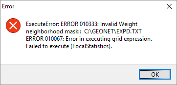
The overwrite setting is not working very well, since when running the code again it tells me this:

I had to close my IDE to be able to delete the previous files. So I decided to throw in a different Focal Statistics operation, which is obviously not the same, but something the allows the code to continue:
rPthPot = sa.FocalStatistics(rGt, sa.NbrCircle(20, 'CELL'), 'MEAN', 'DATA')The additional DATA parameter might be good to include in your code to reduce NoData values in the output. After this the code continued, but returned another error:

While inspecting "rPthPot.maximum" I noticed that the entire raster contains NoData values. So I went back and tried to trace where that raster is based on. When I look at this parte of the code:
rW = (rG0 - rGt_1) * wFactor # (0 - 0) * 0.2 = 0
rMark = rPath * (1.0 - (rGt_1 / rGmax)) * I # 1 * (1-(0/5)) * 4 = 4 or 0
rGt = rGt_1 + rW + rMark # 0 + 0 + 4 or 0 = 4 o 0
rGt.save('rGt.tif')You can see that rW is always 0 and rGt_1 is 0, so rGt is actually rMark and that raster contains value 4 for the route and value 0 for all other pixels. When this raster is used in the calculation it yields an error since it expects a raster or layer and None does not comply to that, since rPthPot.maximum is None.
I switch off that part in case the rPthPot.maximum is None and let the code run again and this time it finished the first iteration but came up with this error:
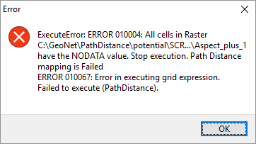
The raster contains all NoData cells and can't be used for the Path Distance. So maybe you can functionally describe what you are trying to do, since there are a number of things in the code that don't make sense to me.