- Home
- :
- All Communities
- :
- Developers
- :
- Python
- :
- Python Questions
- :
- MakeXYEventLayer or FeatureClassToFeatureClass_con...
- Subscribe to RSS Feed
- Mark Topic as New
- Mark Topic as Read
- Float this Topic for Current User
- Bookmark
- Subscribe
- Mute
- Printer Friendly Page
MakeXYEventLayer or FeatureClassToFeatureClass_conversion Cause Crash
- Mark as New
- Bookmark
- Subscribe
- Mute
- Subscribe to RSS Feed
- Permalink
I am new to coding in python, my problems is the machine crashing halfway through first loop, and yet another five with its modules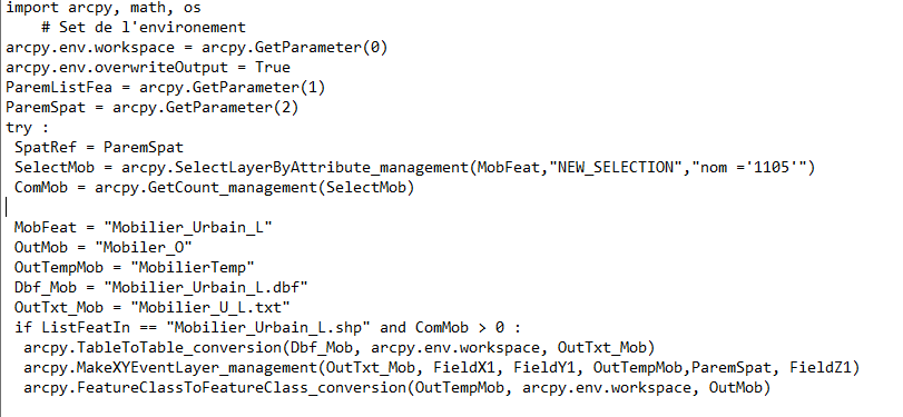 .
.
i have "Serious Application Error" with the opportunity to send info to Esri.
i use script in toolbox, i have arcmap 10.6 .
Thanks.
- Mark as New
- Bookmark
- Subscribe
- Mute
- Subscribe to RSS Feed
- Permalink
The additional information is helpful. Could you share a sample of what the Mobilier_Urbain_L.shp file is like? Also, is it safe to assume that all your shape files use the same format?
I noticed that the FieldX1 used in the MakeXYEventLayer may be the field name and probably should be quoted. I am assuming there is a field in the shape file with this name. If not, you would need to set it to the field's name, such as FieldX1 = 'XfieldName'.
arcpy.MakeXYEventLayer_management(OutTxtMob, 'FieldX1', 'FieldY1', OutTempMob, ParemSpat, 'FieldZ1') - Mark as New
- Bookmark
- Subscribe
- Mute
- Subscribe to RSS Feed
- Permalink
While experimenting with a line shape file, I realized that you do not need to convert the .dbf table to a text file to make use MakeXYEventLayer if it contains X and Y values. For my experiment, I created some lines and save them as a shape file. I used AddGeometryAttributes to add an XY value for the mid-point of the line. The .dbf and .prj files were used to create a point feature. Perhaps the test code will give you some ideas for your project.
import arcpy, os
arcpy.env.workspace = r'C:\Users\Randy\Documents\ArcGIS\PythonScripts\test\rbTest'
arcpy.env.overwriteOutput = True
dbf = 'line_test.dbf' # shape file data table
sr = arcpy.SpatialReference(os.path.join(arcpy.env.workspace,'line_test.prj')) # shape file spatial reference
# print sr.name, sr.factoryCode
FieldX1 = 'MID_X' # midpoint of line feature
FieldY1 = 'MID_y'
FieldZ1 = None
outShape = 'point_test.shp'
points = arcpy.MakeXYEventLayer_management(dbf, FieldX1, FieldY1, 'points', sr, FieldZ1) # make a point layer
result = arcpy.FeatureClassToFeatureClass_conversion(points, arcpy.env.workspace, outShape)
print result
'''
# Replace a layer/table view name with a path to a dataset (which can be a layer file) or create the layer/table view within the script
# The following inputs are layers or table views: "line_test"
CENTROID - Adds attributes to store the centroid coordinates of each feature.
(CENTROID_X, CENTROID_Y)
CENTROID_INSIDE - Adds attributes to store the coordinates of a central point inside or on each feature.
(INSIDE_X, INSIDE_Y)
LINE_START_MID_END - Adds attributes to store the coordinates of the start, mid, and end points of each feature.
(START_X, START_Y, MID_X, MID_Y, END_X, END_Y)
LINE_BEARING - Adds an attribute to store the start-to-end bearing of each line feature.
Values range from 0 to 360, with 0 meaning north, 90 east, 180 south, 270 west, and so on.
(BEARING)
arcpy.AddGeometryAttributes_management(
Input_Features="line_test",
Geometry_Properties="LINE_START_MID_END;CENTROID;CENTROID_INSIDE;LINE_BEARING",
Length_Unit="", Area_Unit="", Coordinate_System="")
'''Hope this helps.
- « Previous
-
- 1
- 2
- Next »
- « Previous
-
- 1
- 2
- Next »