- Home
- :
- All Communities
- :
- Developers
- :
- Python
- :
- Python Questions
- :
- Re: Layer Property - Data Type
- Subscribe to RSS Feed
- Mark Topic as New
- Mark Topic as Read
- Float this Topic for Current User
- Bookmark
- Subscribe
- Mute
- Printer Friendly Page
Layer Property - Data Type
- Mark as New
- Bookmark
- Subscribe
- Mute
- Subscribe to RSS Feed
- Permalink
from arcpy you can use Describe to find out what object types you have
Describe—Data Access module | Documentation
then burrow in further
CAD FeatureClass properties—ArcPy Functions | Documentation
only to discover that CAD featureclasses return FeatureClass as the DataType
but
Dataset properties—ArcPy Functions | Documentation
allows you to determine whether a dataset type
- Mark as New
- Bookmark
- Subscribe
- Mute
- Subscribe to RSS Feed
- Permalink
Thanks Dan. I’m going through the links you sent to see if there’s a way I can workaround with the describe object to get at what I’m looking for as it seems I can’t directly get at what I want using arcpy (according to Joshua).
- Mark as New
- Bookmark
- Subscribe
- Mute
- Subscribe to RSS Feed
- Permalink
maybe skip Arc* altogether and just use windows file explorer ![]()
- Mark as New
- Bookmark
- Subscribe
- Mute
- Subscribe to RSS Feed
- Permalink
The short answer is that you can't get that specific value from within ArcPy.
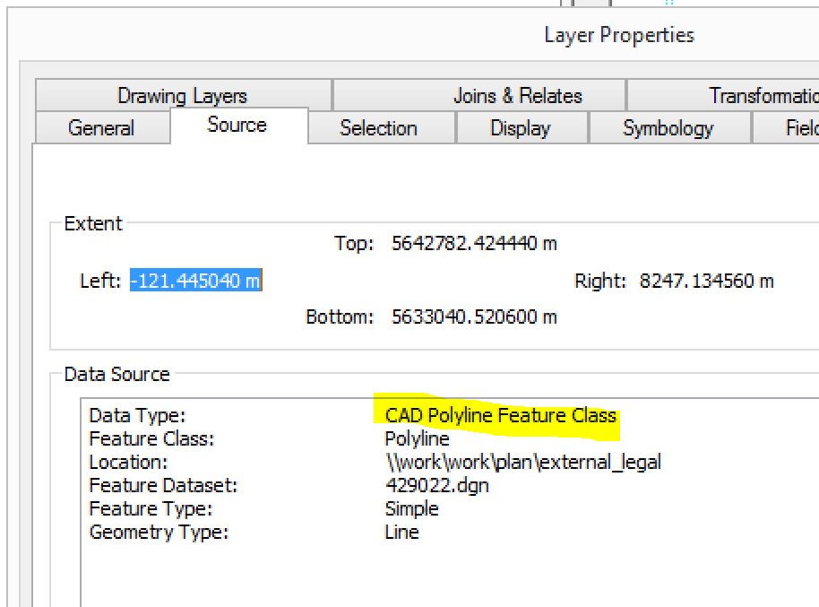
The Data Type value of the Data Source tab comes from IFeatureLayer.DataSourceType, i.e., it is a layer value/description and not a dataset value/description. Unfortunately, ArcPy does not expose that layer property through the Describe object.
If you are willing to install a Python com package, like GitHub - enthought/comtypes: A pure Python, lightweight COM client and server framework, based on th... , then you can use ArcObjects to access the value.
The code below, when pasted in the interactive Python window, will enumerate all the feature layers in the MXD and print their names and layer-based DataSourceType.
import arcpy
import os
from comtypes.client import CreateObject, GetModule
mxd = "" # path to MXD file (if run outside ArcMap)
# Function for casting COM objects to interfaces
def CType(obj, interface):
"""Casts obj to interface and returns comtypes POINTER or None"""
try:
newobj = obj.QueryInterface(interface)
return newobj
except:
return None
# Path to ArcGIS Desktop COM files
comDirectory = os.path.join(
os.path.join(arcpy.GetInstallInfo()['InstallDir']), 'com'
)
# References to needed ArcGIS Desktop COM components
esriSystem = GetModule(os.path.join(comDirectory, 'esriSystem.olb'))
esriFramework = GetModule(os.path.join(comDirectory, 'esriFramework.olb'))
esriArcMapUI = GetModule(os.path.join(comDirectory, 'esriArcMapUI.olb'))
esriCarto = GetModule(os.path.join(comDirectory, 'esriCarto.olb'))
# Create filter for layers that support IGeoFeatureLayer
pUID = CreateObject(esriSystem.UID)
pUID.Value = "{40A9E885-5533-11d0-98BE-00805F7CED21}"
# Section for running within ArcGIS Desktop application
# Confirm code is being run within ArcMap (Interactive, Addin, Toolbox)
try:
pApp = CreateObject(esriFramework.AppRef)
assert pApp.Name == 'ArcMap', 'Code must be run within ArcMap'
pMxDoc = CType(pApp.Document, esriArcMapUI.IMxDocument)
except WindowsError:
assert False, 'Code must be run within an ArcGIS Desktop application'
## Section for running outside of ArcGIS Desktop application
## Open MXD file
#try:
# pMapDoc = CreateObject(esriCarto.MapDocument, interface=esriCarto.IMapDocument)
# assert pMapDoc.IsMapDocument(mxd), 'Valid MXD required'
# pMapDoc.Open(mxd)
# pMap = pMapDoc.Map(0)
#except:
# assert False, 'Unable to open MXD and retrieve map'
# Loop over layers that support IGeoFeatureLayer (first line from in ArcMap, second line outside of ArcMap)
pEnumLayer = pMxDoc.FocusMap.Layers(pUID, True)
# pEnumLayer = pMap.Layers(pUID, True)
results = ["LayerName, DataSourceType"]
pEnumLayer.Reset()
pLayer = pEnumLayer.Next()
while pLayer:
pFeatureLayer = CType(pLayer, esriCarto.IFeatureLayer2)
# Append results and move to next layer
results.append("{}, {}".format(pLayer.Name, pFeatureLayer.DataSourceType))
pLayer = pEnumLayer.Next()
for res in results:
print(res)- Mark as New
- Bookmark
- Subscribe
- Mute
- Subscribe to RSS Feed
- Permalink
Thanks Joshua. I think that opens a whole new can of worms I don’t really want to get into ideally.
