- Home
- :
- All Communities
- :
- Developers
- :
- Python
- :
- Python Questions
- :
- How to transform images (Flip and Rotate) using Py...
- Subscribe to RSS Feed
- Mark Topic as New
- Mark Topic as Read
- Float this Topic for Current User
- Bookmark
- Subscribe
- Mute
- Printer Friendly Page
How to transform images (Flip and Rotate) using Python?
- Mark as New
- Bookmark
- Subscribe
- Mute
- Subscribe to RSS Feed
- Permalink
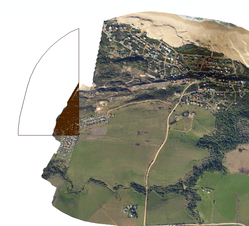
I have received imagery from a surveyor that is currently falling within the Northern Hemisphere and upside down. The following is easy to resolve if its a CAD drawing using the "Transformations" tab under the properties window of the CAD layer within ArcMap. Is there a way to apply the same transformation using Python for each image tile?
CAD: Transformation
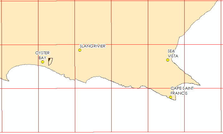
Original Position: Northern Hemisphere and rotated.
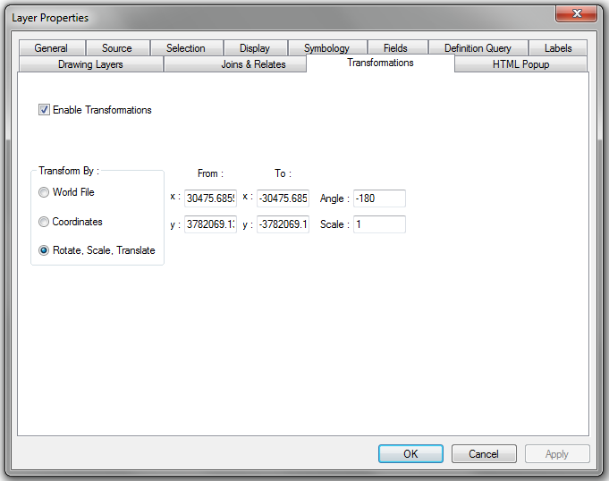
CAD: Transformation and Rotation
CAD: Transformed (correct location)
Imagery: Current Imagery (Northern hemisphere and rotated)
Any assistance to achieve the following will be appreciated.
Solved! Go to Solution.
Accepted Solutions
- Mark as New
- Bookmark
- Subscribe
- Mute
- Subscribe to RSS Feed
- Permalink
You could try use the third party 'Pillow' python module.
This should allow you to rotate multiple images at once.
- Mark as New
- Bookmark
- Subscribe
- Mute
- Subscribe to RSS Feed
- Permalink
Have you tried Flip—Help | ArcGIS Desktop ?
Think Location
- Mark as New
- Bookmark
- Subscribe
- Mute
- Subscribe to RSS Feed
- Permalink
I bet you don't have world files for the images... Sounds like a missing negative sign and a flop of the X and Y coordinates... World files would be a lot faster to fix
- Mark as New
- Bookmark
- Subscribe
- Mute
- Subscribe to RSS Feed
- Permalink
I agree with Dan, and would first take a look at the world file first in case a negative sign is missing or reversed.
Some links that might help:
- World files for CAD datasets—Help | ArcGIS for Desktop
- World files for raster datasets—Help | ArcGIS Desktop
- older blog My image is in the wrong spot | ArcGIS Blog
- World file - Wikipedia
If the world file doesn't work, then I would look into the flip...but make sure you know what the input world file and/or spatial reference is, so you can figure out what you need to correct it. You can usually find out this info in ArcCatalog with are right-click to look at the properties.
(I don't have any experience with the "pillow" python mod...but I plan to check it out too).
- Mark as New
- Bookmark
- Subscribe
- Mute
- Subscribe to RSS Feed
- Permalink
You could try use the third party 'Pillow' python module.
This should allow you to rotate multiple images at once.
- Mark as New
- Bookmark
- Subscribe
- Mute
- Subscribe to RSS Feed
- Permalink
Hi Richard
Thanks I clean forgot about Python's Pillow module. I was able to batch all the images and correct them.