- Home
- :
- All Communities
- :
- Developers
- :
- Python
- :
- Python Questions
- :
- Geoprocessing Script to Clip based on Two Attribut...
- Subscribe to RSS Feed
- Mark Topic as New
- Mark Topic as Read
- Float this Topic for Current User
- Bookmark
- Subscribe
- Mute
- Printer Friendly Page
Geoprocessing Script to Clip based on Two Attributes
- Mark as New
- Bookmark
- Subscribe
- Mute
- Subscribe to RSS Feed
- Permalink
Hi All,
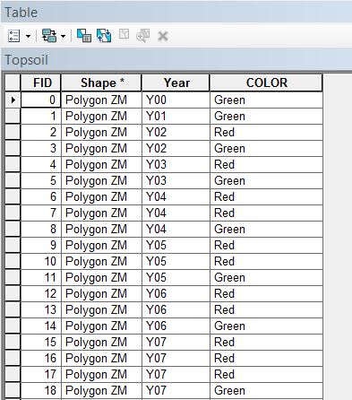
I am looking for a method to do a clip based on two attributes. In the attached shapefile, I have a "Year" field with years ranging from 0 to 27 and a "COLOR" field populated with either Red or Green. I am looking for the best way to cycle through each year and clip the Red polygons from the Green polygons (discarding the area that intersects). Is a python script or iterative model the best approach for this? I am still a novice python user but very interested in learning more about it. Any help with this would be greatly appreciated.
Thanks,
Jason
- Mark as New
- Bookmark
- Subscribe
- Mute
- Subscribe to RSS Feed
- Permalink
Hello Jason,
You could also try this. I could call it a LAYMAN method.
1) Use Geoprocessing > Union tool to delineate the boundaries.
2) From the ouput layer from UNION, convert feature to point.
3) Start editing. From the points layer, select (by attribute) the points where [COLOR]= "Red" and delete them. Save edits.
4) Then go for a Select by Location where
Target Layer: Union_output (polygon)
Source Layer: Point_layer (point)
Spatial Selection Method: Contain the source layer feature.
Delete the selected features (These are the overlapping features). Save edits.
5) In the Union_Output layer, Select (by attribute) the polygons where [COLOR]= "Red" and delete them. Save and stop editing.
The Union_Output will now contain the features where [COLOR]="Red".
6) Dissolve the above layer based on [YEAR] and [COLOR] (Choosing the [COLOR] field is optional, since all the features in this layer are red).
Think Location
- Mark as New
- Bookmark
- Subscribe
- Mute
- Subscribe to RSS Feed
- Permalink
Great, Thank you Jayanta. I will give this a try.
Thanks for the reply!
Jason
- Mark as New
- Bookmark
- Subscribe
- Mute
- Subscribe to RSS Feed
- Permalink
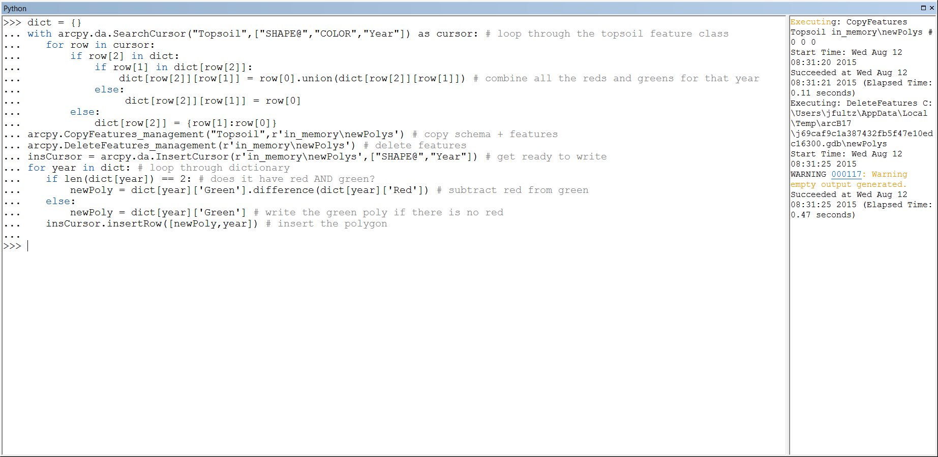
Here is an alternative way to get to your answer, using arcpy geometry objects, directly:
>>> dict = {}
... with arcpy.da.SearchCursor("Topsoil",["SHAPE@","COLOR","Year"]) as cursor: # loop through the topsoil feature class
...    for row in cursor:
...        if row[2] in dict:
...            if row[1] in dict[row[2]]:
...                dict[row[2]][row[1]] = row[0].union(dict[row[2]][row[1]]) # combine all the reds and greens for that year
...            else:
...                dict[row[2]][row[1]] = row[0]
...        else:
...            dict[row[2]] = {row[1]:row[0]}
... arcpy.CopyFeatures_management("Topsoil",r'in_memory\newPolys') # copy schema + features
... arcpy.DeleteFeatures_management(r'in_memory\newPolys') # delete features
... insCursor = arcpy.da.InsertCursor(r'in_memory\newPolys',["SHAPE@","Year"]) # get ready to write
... for year in dict: # loop through dictionary
...    if len(dict[year]) == 2: # does it have red AND green?
...        newPoly = dict[year]['Green'].difference(dict[year]['Red']) # subtract red from green
...    else:
...        newPoly = dict[year]['Green'] # write the green poly if there is no red
...    insCursor.insertRow([newPoly,year]) # insert the polygon
- Mark as New
- Bookmark
- Subscribe
- Mute
- Subscribe to RSS Feed
- Permalink
Thanks for providing this, Darren. I will give it a try. As I mentioned above, I seem to be having issues saving a script from GeoNet and running it in IDLE or the ArcGIS Python window. Any idea how to best save this without the row numbers?
Thanks again,
Jason
- Mark as New
- Bookmark
- Subscribe
- Mute
- Subscribe to RSS Feed
- Permalink
I gave this script a try but received an error stating "Empty Output Generated". Would it have stopped because Year 00 only has a green polygon, and not a red polygon, so no clipping would be necessary for Y00?
Thanks again,
Jason
- « Previous
-
- 1
- 2
- Next »
- « Previous
-
- 1
- 2
- Next »