- Home
- :
- All Communities
- :
- Developers
- :
- Python
- :
- Python Questions
- :
- Re: Finding the shortest edge length of polygons
- Subscribe to RSS Feed
- Mark Topic as New
- Mark Topic as Read
- Float this Topic for Current User
- Bookmark
- Subscribe
- Mute
- Printer Friendly Page
Finding the shortest edge length of polygons
- Mark as New
- Bookmark
- Subscribe
- Mute
- Subscribe to RSS Feed
- Permalink
There is no direct tool for that. The process would entail scripting
- convert each polygon to a polyline
- devolve each polyline into its parts
- calculate the length of each segment, retaining the shortest length while cycling through the parts.
Concerns
- you will need to ensure that each polygon initially has extraneous vertices removed (Generalize, removing points on the perimeter that aren't part of a direction change.
- do you need the actual edge or do you need to get a measure of the shortest of the width or height of the minimum area bounding rectangle or the minimum bounding extent
Perhaps you could elaborate on the purpose for identifying the 'shortest polygon edge'
- Mark as New
- Bookmark
- Subscribe
- Mute
- Subscribe to RSS Feed
- Permalink
Concerns
- you will need to ensure that each polygon initially has extraneous vertices removed (Generalize, removing points on the perimeter that aren't part of a direction change.
To add to this, a shape you see as a 'rectangle', may actually be composed of smaller edges that look like 4 edges when you zoom out far enough inside the GIS. (e.g. the computer sees it as a 18 sided polygon, not a rectangle!) The generalise tool can help simplify the shape, but you need to enter tolerances that make sense with your particular data.
Simple example:
Actual Coords (5 sided shape to the computer):
1,1 1,2 2,2 2,1 2.02, 1.02
Human interpreted coords (Shape looks like a rectangle to me as the final vertex added nothing):
1,1 1,2 2,2 2,1
In this example, if I generalise the input data with a 0.05m tolerance, it would clean out the node thats not required as the 0.02 metre deviation has less effect on the shape of the polygon than the 0.05 tolerance.. and is therefore not required.
- Mark as New
- Bookmark
- Subscribe
- Mute
- Subscribe to RSS Feed
- Permalink
I have used the code below in the past to find the longest edge of a polygon, but you could rewrite it to find the shortest edge. However, there could be some discussion on what an edge is or how this should be interpreted:
def GetLargestLine(polygon, offset):
max_length = 0
prev_pnt = None
side = None
sr = polygon.spatialReference
polygon2 = polygon.generalize(0.1)
for part in polygon2:
for pnt in part:
# print pnt
if prev_pnt is None:
pass
else:
if pnt is None:
pass
else:
length = GetDist(pnt, prev_pnt)
if length > max_length:
max_length = length
side = arcpy.Polyline(arcpy.Array([prev_pnt, pnt]), sr)
prev_pnt = pnt
length = side.length
side = side.segmentAlongLine(offset, length-offset, False)
return side, lengthThis was used to generate solar panels on roof tops. See document here (Spanish content):
- Mark as New
- Bookmark
- Subscribe
- Mute
- Subscribe to RSS Feed
- Permalink
Hust did a little test to see if it would work and I get a result with this code (it will add fields to the input featureclass, so it's better to run this on a copy of your data):
def main():
# will change the input fc (adding fields!)
import arcpy
fc = r'C:\GeoNet\ShortestEdge\data.gdb\polygons'
generalize = 0.1 # change this value according to the tolerance in your data
fc_out = r'C:\GeoNet\ShortestEdge\data.gdb\lines_v01'
# output fields
fld_len1 = "ShortestLength1"
fld_from_pnt1 = "FromPoint1"
fld_to_pnt1 = "ToPoint1"
fld_len2 = "ShortestLength2"
fld_from_pnt2 = "FromPoint2"
fld_to_pnt2 = "ToPoint2"
# add fields
AddField(fc, fld_len1, "DOUBLE", None)
AddField(fc, fld_from_pnt1, "TEXT", 100)
AddField(fc, fld_to_pnt1, "TEXT", 100)
AddField(fc, fld_len2, "DOUBLE", None)
AddField(fc, fld_from_pnt2, "TEXT", 100)
AddField(fc, fld_to_pnt2, "TEXT", 100)
# update cursor
feats = []
flds = ('SHAPE@', fld_len1, fld_from_pnt1, fld_to_pnt1,
fld_len2, fld_from_pnt2, fld_to_pnt2)
with arcpy.da.UpdateCursor(fc, flds) as curs:
for row in curs:
polygon = row[0]
length1, from_pnt1, to_pnt1, line1 = GetShortestEdgeData(polygon)
feats.append(line1)
polygon2 = polygon.generalize(generalize)
length2, from_pnt2, to_pnt2, line2 = GetShortestEdgeData(polygon2)
feats.append(line2)
curs.updateRow((polygon, length1, from_pnt1, to_pnt1, length2, from_pnt2, to_pnt2, ))
# write lines to output fc for visual reference
arcpy.CopyFeatures_management(feats, fc_out)
def AddField(fc, fld_name, fld_type, fld_length):
if len(arcpy.ListFields(fc, fld_name)) == 0:
arcpy.AddField_management(fc, fld_name, fld_type, None, None, fld_length)
def GetShortestEdgeData(polygon):
min_length = 99999
prev_pnt = None
side = None
sr = polygon.spatialReference
for part in polygon:
for pnt in part:
if prev_pnt is None:
pass
else:
if pnt is None:
pass
else:
length = GetDist(pnt, prev_pnt)
if length < min_length:
min_length = length
line = arcpy.Polyline(arcpy.Array([prev_pnt, pnt]), sr)
prev_pnt = pnt
length = line.length
from_pnt = line.firstPoint
to_pnt = line.lastPoint
return length, str(from_pnt), str(to_pnt), line
def GetDist(pnt1, pnt2):
import math
return math.hypot(pnt2.X - pnt1.X, pnt2.Y - pnt1.Y)
if __name__ == '__main__':
main()It will do this on the input polygon and a generalized polygon (set the variable generalize on line 5 with a proper value):
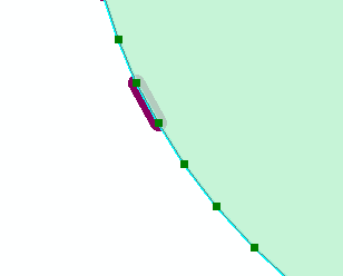
It also creates an output featureclass with the shortest edges.
- Mark as New
- Bookmark
- Subscribe
- Mute
- Subscribe to RSS Feed
- Permalink
Thanks everyone for your quick responses and great answers!
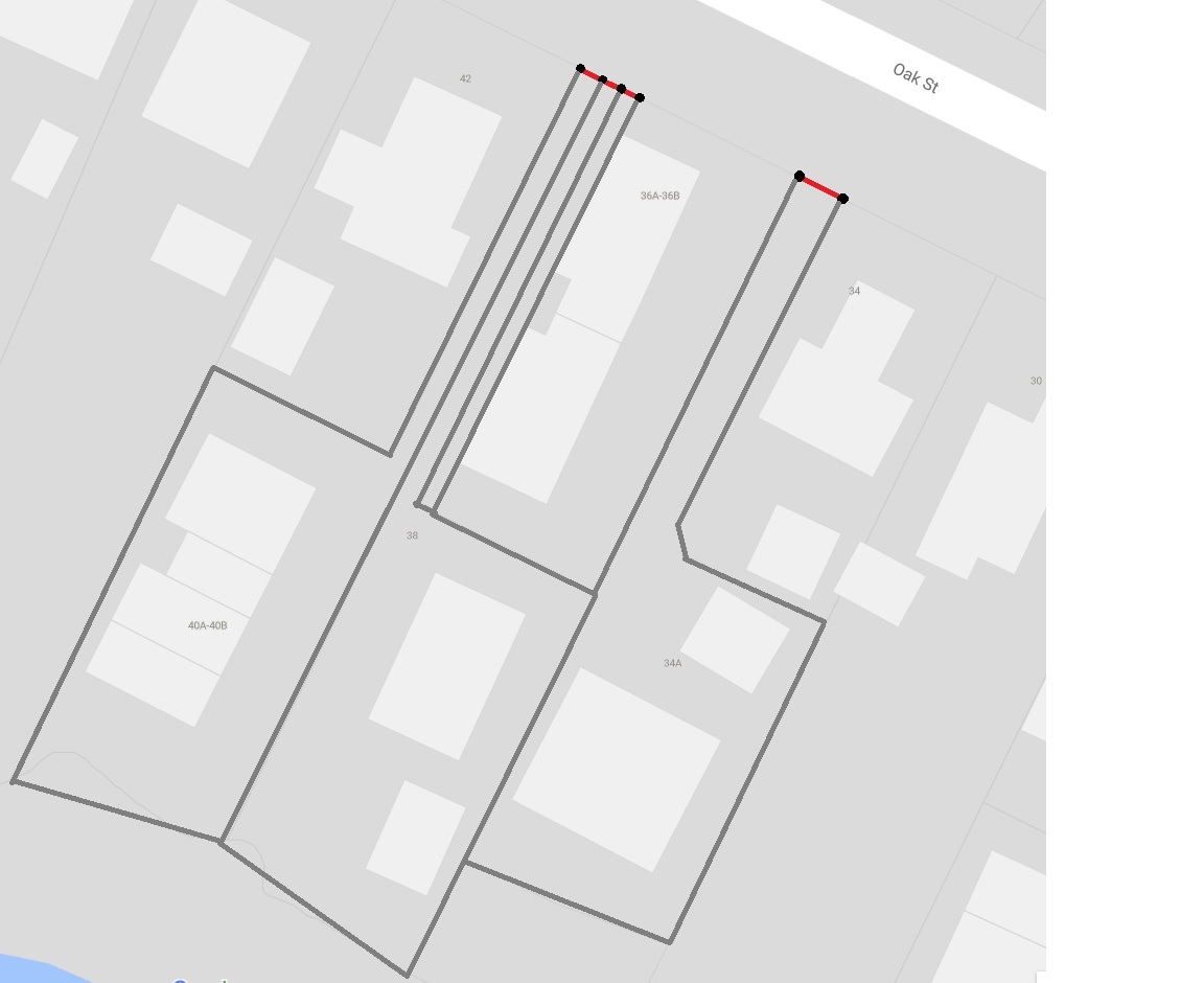
Solution is no longer needed (unfortunately), but for curiosity's sake, I was attempting to identify houses with long driveways (right of way access) by finding land parcel shapes with a short perimeter edge to represent a driveway edge. I couldn't find any other data source to indicate these so this is the best solution I could come up with.