- Home
- :
- All Communities
- :
- Developers
- :
- Python
- :
- Python Questions
- :
- Re: Extracting rasters from NetCDF files based on ...
- Subscribe to RSS Feed
- Mark Topic as New
- Mark Topic as Read
- Float this Topic for Current User
- Bookmark
- Subscribe
- Mute
- Printer Friendly Page
Extracting rasters from NetCDF files based on time dimension
- Mark as New
- Bookmark
- Subscribe
- Mute
- Subscribe to RSS Feed
- Permalink
I have single netCDF file which contain monthly data for different year. (Format of date e.g 2001-1-1, 2001-2-1, 2001-3-1…….2002-12-1...............2015-0-1......2015-12-1).
Here-with i have attached a snapshot of data format from Arc GIS multidimension tool
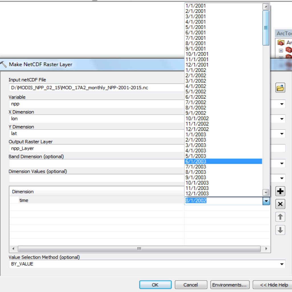
I trying to extract each month raster for selected year (e.g only 2002). Save it as 01-2002, 02-2002, 03-2002…..12-2002.
I appreciate any help you can provide on the crucial bottom code.
Here is what I have so far:
# Import system modules
import arcpy
from arcpy import env
from arcpy.sa import *
#Workspace
outLoc = r"D:\MODIS_NPP_02_15"
inNetCDF = r"D:\MODIS_NPP_02_15\NPP_2001_15.nc"
#Veriable
variable = "npp"
x_dimension = "lon"
y_dimension = "lat"
band_dimension = ""
dimension = "time"
valueSelectionMethod = "BY_VALUE"
nc_FP = arcpy.NetCDFFileProperties(inNetCDF)
nc_Dim = nc_FP.getDimensions()
for dimension in nc_Dim:
if dimension == "time":
top = nc_FP.getDimensionSize(dimension)
for i in range(0, top):
dimension_values = nc_FP.getDimensionValue(dimension, i)
nowFile = str(dimension_values)
nowFile = nowFile.translate(None, '/')
# I needed only the years 2002
if int(nowFile[-12]) > 6:
dv1 = ["time", dimension_values]
dimension_values = [dv1]
arcpy.MakeNetCDFRasterLayer_md(inNetCDF, variable, x_dimension, y_dimension, nowFile, band_dimension, dimension_values, valueSelectionMethod)
print "success"
outname = outLoc + nowFile
arcpy.CopyRaster_management(nowFile, outname, +".tif","", "", "", "NONE", "NONE", "")
else: print "DATA OUT OF RANGE"- Mark as New
- Bookmark
- Subscribe
- Mute
- Subscribe to RSS Feed
- Permalink
Dan Patterson, I corrected the line by replace line no 4 suggested by you. Now i am getting following error massage. Error massage displaying output raster name can't be more than 13 character. So whats is the possible way to short the output raster name
Message File Name Line Position
Traceback
<module> D:\Arc-GIS-Python-Script\NetCDF_RASTER_TIME_SERIES.py 39
CopyRaster C:\Program Files\ArcGIS\Desktop10.1\arcpy\arcpy\management.py 11034
ExecuteError: Failed to execute. Parameters are not valid.
ERROR 000472: Name of single band grid cannot have more than 13 characters
Failed to execute (CopyRaster).
- Mark as New
- Bookmark
- Subscribe
- Mute
- Subscribe to RSS Feed
- Permalink
Yes... esri grids can't have filenames that long... the solution is to shorten what your have or make up a new name
>>> outLoc = r"D:\MODIS_NPP_02_15"
>>> outFile = "abcdefghijklmnopqrstuvwxyz"
>>> outfile = "abcdefghijklmnNPP_2001_15"
>>> result = outLoc + "\\N" + outfile[-7:]
>>> result
'D:\\MODIS_NPP_02_15\\N2001_15'
>>>
>>> # or for slice/dice and replace all at once...
>>>
>>> result2 = outLoc + "\\N" + outfile[-7:].replace("200","0")
>>> result2
'D:\\MODIS_NPP_02_15\\N01_15'
>>>
- Mark as New
- Bookmark
- Subscribe
- Mute
- Subscribe to RSS Feed
- Permalink
i renamed the input name as well as folder name to make it short, but error still persist . PyScripter getting crash
Message File Name Line Position
Traceback
__call__ E:\Geo_Softwares\PyScripter\PyScripter\Lib\rpyc.zip\rpyc\core\netref.py 196
syncreq E:\Geo_Softwares\PyScripter\PyScripter\Lib\rpyc.zip\rpyc\core\netref.py 71
sync_request E:\Geo_Softwares\PyScripter\PyScripter\Lib\rpyc.zip\rpyc\core\protocol.py 431
serve E:\Geo_Softwares\PyScripter\PyScripter\Lib\rpyc.zip\rpyc\core\protocol.py 379
_recv E:\Geo_Softwares\PyScripter\PyScripter\Lib\rpyc.zip\rpyc\core\protocol.py 337
recv E:\Geo_Softwares\PyScripter\PyScripter\Lib\rpyc.zip\rpyc\core\channel.py 50
read E:\Geo_Softwares\PyScripter\PyScripter\Lib\rpyc.zip\rpyc\core\stream.py 166
exceptions.EOFError: [Errno 10054] An existing connection was forcibly closed by the remote host
- Mark as New
- Bookmark
- Subscribe
- Mute
- Subscribe to RSS Feed
- Permalink
It is the folder name and the file name that is more important. And rpyc.zip... how does that come into play?
- « Previous
-
- 1
- 2
- Next »
- « Previous
-
- 1
- 2
- Next »