- Home
- :
- All Communities
- :
- Developers
- :
- Python
- :
- Python Questions
- :
- DTM AND DSM
- Subscribe to RSS Feed
- Mark Topic as New
- Mark Topic as Read
- Float this Topic for Current User
- Bookmark
- Subscribe
- Mute
- Printer Friendly Page
DTM AND DSM
- Mark as New
- Bookmark
- Subscribe
- Mute
- Subscribe to RSS Feed
- Permalink
how could import dtm and dsm on gis 10.4.1?
- Mark as New
- Bookmark
- Subscribe
- Mute
- Subscribe to RSS Feed
- Permalink
I have unmarked my answer as the correct one, since no solution was provided. Is the file very large or is it not possible to attach a sample file to the thread? You will have a higher chance to get a solution if more than a single person have access to this file. If you are not allowed to share it publicly, I can provide my contact info.
- Mark as New
- Bookmark
- Subscribe
- Mute
- Subscribe to RSS Feed
- Permalink
ok give me your contact info
- Mark as New
- Bookmark
- Subscribe
- Mute
- Subscribe to RSS Feed
- Permalink
You can send me an email using xander_bakker [at] yahoo.com
- Mark as New
- Bookmark
- Subscribe
- Mute
- Subscribe to RSS Feed
- Permalink
I send te file now ......
- Mark as New
- Bookmark
- Subscribe
- Mute
- Subscribe to RSS Feed
- Permalink
ok I send now you can see .....
- Mark as New
- Bookmark
- Subscribe
- Mute
- Subscribe to RSS Feed
- Permalink
Sorry for the delay. The file can be read without any problems into Desktop (see screenshot in ArcMap below) no conversion required:

The steps are easy, assuming you have ArcMap or ArcGIS Pro:
1) In ArcMap, click the add data button:

2) navigate to the folder where the file is or files are stored, select the file and click on the Add button:

As a result the file will be added to the TOC and you can start to manipulate the file. Please note that the file as you shared does not have a projection and you should use the Define Projection—Help | ArcGIS Desktop tool to assign the appropriate projected coordinate system.
As far as I can tell the raster is a classified raster where you will only have values in steps of 100m (no intermediate values). To get something "useful" you may need to extract the contours every 100 meters with Contour—Help | ArcGIS Desktop followed by Topo to Raster—Help | ArcGIS Desktop to interpolate the contour lines and create a real DEM.
- Mark as New
- Bookmark
- Subscribe
- Mute
- Subscribe to RSS Feed
- Permalink
.....but try it in arcmap with the Add Data button first ....
suggested before in an earlier post of mine...
I wonder why it didn't work before???
- Mark as New
- Bookmark
- Subscribe
- Mute
- Subscribe to RSS Feed
- Permalink
HI
I have arcmap I will try
- Mark as New
- Bookmark
- Subscribe
- Mute
- Subscribe to RSS Feed
- Permalink
yes its open on arcmap but i have try to import lat,lot point but inst simple for import and
what can I do for this import point in dtm or dsm ?
- Mark as New
- Bookmark
- Subscribe
- Mute
- Subscribe to RSS Feed
- Permalink
I believe the the original question on how to open the file in ArcMap has been resolved, basically with the suggestion that Dan Patterson made earlier in this thread "but try it in arcmap with the Add Data button first", which worked. I added some images to make it more visual, and detected some problems with the data.
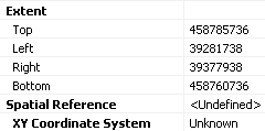
As far as I understand, you have a follow-up question about the coordinates and mention importing a lat, lon point. I guess you refer at defining a coordinate system since the data has coordinate which range from 39,281,738 to 39,377,938 in X (lon) and 458,760,736 to 458,785,736 in Y (lat):
Those are very high values for coordinates. Normally when you obtain data the data will be accompanied by some metadata explaining the content and in this case the coordinate system. You should ask the owner of the data when spatial reference and units have been used for this dataset. Only then you will be able to assign the correct coordinate system to the data (so it will know its location in the surface of the earth) and you are able to project the dataset into another coordinate system in you you require geographic coordinates (lat and lon). If you do not have information about the data and its coordinate system you will need to "guess" which coordinate system it is, by using knowledge of the area it describes with all the possible consequences of errors. The other aspect still remains; the dataset is not really a DEM or DTM. It is a classified derivative and should be treated as such. For example you cannot create a slope map from this raster or calculate aspects or do any hydrological analysis on it.Be aware of that.