- Home
- :
- All Communities
- :
- Developers
- :
- Python
- :
- Python Questions
- :
- Calculating adjacent fishnet fields
- Subscribe to RSS Feed
- Mark Topic as New
- Mark Topic as Read
- Float this Topic for Current User
- Bookmark
- Subscribe
- Mute
- Printer Friendly Page
Calculating adjacent fishnet fields
- Mark as New
- Bookmark
- Subscribe
- Mute
- Subscribe to RSS Feed
- Permalink
Hello everyone,
I dont know where to ask this, it is related to arcmap and python.
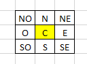
I have a layer that it is a grid (i think it is called fishnet) and I have several fields (Represented with C in the diagram with some value). I have to calculate the adjacent fields of C ( N, NE , NO , O, E, SO ,S , SE ) and their value too.
How can archieve that?
I am pretty new using the tool and I want to know more or less the arctools that i have to use to get the values around the center.
There is another issue, sometimes not all the adjacent fields have value (I could be for example, NO or N are not available, but the rest of the other are).
Of course, every N, NE , NO , O, E, SO ,S , SE has their own value, and the logic that I have to apply is the following:
N = C(value) + N(value)
NE = C(value) + NE(Value)
SO = C(value) + SO (Value)
etc.
After that i have to only filter the values that have a certain range, so most likely not all the values that i will get are going to work.
I hope somebody can guide me on how to do this.
Thanks in advice
- Mark as New
- Bookmark
- Subscribe
- Mute
- Subscribe to RSS Feed
- Permalink
This code works and does the calculations of the surrounding blocks then writes them to a CSV file that can be opened in excel. I only tested the script with a polygon fishnet layer. This might work with a polyline fishnet layer. Since I didn't know where you stored the number information to be calculated, for simplicity I assumed the number information would be stored in the fishnet layer as well. If you are working with two different layers please let me know so I can swap around some variables so the geometry function within the code checks for touches between the two layers and not within a single layer.
The code is also commented to help you change the needed variables to point to the correct places within your dataset. The script will also make a folder called Calculation in the same directory as the script, so you should be able to find it easily.
The variables you need to change are:
name_Field
number_Field
centerBlock
fishNetFc
import arcpy
import os
import csv
# This code is meant to run with python 3 which is the python version of ArcGIS Pro
########################################################################################################################
########################################################################################################################
#
# CHANGE THE VARIABLES BELOW
#
########################################################################################################################
########################################################################################################################
# This variable is the name of the field that contains the label information for the Fishnet layer. Change it to match
# your dataset
name_Field = "Name"
# This variable is the name of the field that contains the number information that will be calculated. Change it to match
# your dataset
number_Field = "Number"
# This variable is the label name of the center block in the fishnet layer. Replace it with the name of the center block in your data
ceneterBlock = "C"
# This variable is the file path to the Fishnet layer. Change the text in between the quotes with the path to your fishnet layer
# Do not delete the r or the quotation marks
fishNetFC = r"C:\Users\JohnDoe\Documents\ArcGIS\Projects\General\General.gdb\Fishnet_test_polygon"
########################################################################################################################
########################################################################################################################
#
# STOP, DO NOT CHANGE ANYTHING ELSE
#
########################################################################################################################
########################################################################################################################
# This creates the Calculation folder to store the CSV file if it doesnt exist.
if os.path.exists(os.path.dirname(os.path.abspath(__file__)) + "\\" + "Calculation") == False:
os.mkdir(os.path.dirname(os.path.abspath(__file__)) + "\\" + "Calculation")
# This deletes the old CSV file so the calculations are the most current run in the CSV file
if os.path.exists(os.path.dirname(os.path.abspath(__file__)) + "\\" + "Calculation" + "\\" + "FishNetCalc.csv") == True:
os.remove(os.path.dirname(os.path.abspath(__file__)) + "\\" + "Calculation" + "\\" + "FishNetCalc.csv")
# This is the path of where the CSV with the calculations will be created.
fishNetCalcCsv = os.path.dirname(os.path.abspath(__file__)) + "\\" + "Calculation" + "\\" + "FishNetCalc.csv"
# This variable creates and opens the CSV file as writable
csvWriter = open(fishNetCalcCsv, "w", newline="")
# This creates the headers in the CSV file
with csvWriter as f:
writerEdit = csv.writer(f)
writerEdit.writerow(["Center_Block", "Surrounding_Block", "Calculation"])
# This does a loop through the fishnet layer. Finds the center block, pauses at the middle block, does another loop through the data again to allow for calculations against
# the middle block
for geomTouchLoop1 in arcpy.da.SearchCursor(fishNetFC, ["SHAPE@", name_Field, number_Field]):
if geomTouchLoop1[1] == ceneterBlock:
for geomTouchLoop2 in arcpy.da.SearchCursor(fishNetFC, ["SHAPE@", name_Field, number_Field]):
if geomTouchLoop2[1] == ceneterBlock:
continue
# This if statement does a geometry check on all of the geometry that touches the middle block then does the calculations and writes them to the CSV file
if geomTouchLoop1[0].touches(geomTouchLoop2[0]):
writer2 = open(fishNetCalcCsv, "a", newline="")
with writer2 as f2:
writer2Edit = csv.writer(f2)
calculations = geomTouchLoop1[2] + geomTouchLoop2[2]
writer2Edit.writerow([geomTouchLoop1[1], geomTouchLoop2[1], calculations])
print("Done!!")
exit()- Mark as New
- Bookmark
- Subscribe
- Mute
- Subscribe to RSS Feed
- Permalink
I updated the code to for the calculation to handle exceptions for non-integer entries. The code also kicks out text to let you know where it found a non-integer and it will pass over it doing the calculations for the other blocks.
It will say something like this:
Found a Non-Integer In the fishnet layer, at block: SO Continuing
Doing Calculation for block: C and Block: S
Doing Calculation for block: C and Block: SE
Found a Non-Integer In the fishnet layer, at block: O Continuing
Doing Calculation for block: C and Block: E
Doing Calculation for block: C and Block: NO
Doing Calculation for block: C and Block: N
Found a Non-Integer In the fishnet layer, at block: NE Continuing
Done!!
Here is the updated code:
import arcpy
import os
import csv
# This code is meant to run with python 3 which is the python version of ArcGIS Pro
########################################################################################################################
########################################################################################################################
#
# CHANGE THE VARIABLES BELOW
#
########################################################################################################################
########################################################################################################################
# This variable is the name of the field that contains the label information for the Fishnet layer. Change it to match
# your dataset
name_Field = "Name"
# This variable is the name of the field that contains the number information that will be calculated. Change it to match
# your dataset
number_Field = "Number"
# This variable is the label name of the center block in the fishnet layer. Replace it with the name of the center block in your data
ceneterBlock = "C"
# This variable is the file path to the Fishnet layer. Change the text in between the quotes with the path to your fishnet layer
# Do not delete the r or the quotation marks
fishNetFC = r"C:\Users\JohnDoe\Documents\ArcGIS\Projects\General\General.gdb\Fishnet_test_polygon"
########################################################################################################################
########################################################################################################################
#
# STOP, DO NOT CHANGE ANYTHING ELSE
#
########################################################################################################################
########################################################################################################################
# This creates the Calculation folder to store the CSV file if it doesnt exist.
if os.path.exists(os.path.dirname(os.path.abspath(__file__)) + "\\" + "Calculation") == False:
os.mkdir(os.path.dirname(os.path.abspath(__file__)) + "\\" + "Calculation")
# This deletes the old CSV file so the calculations are the most current run in the CSV file
if os.path.exists(os.path.dirname(os.path.abspath(__file__)) + "\\" + "Calculation" + "\\" + "FishNetCalc.csv") == True:
os.remove(os.path.dirname(os.path.abspath(__file__)) + "\\" + "Calculation" + "\\" + "FishNetCalc.csv")
# This is the path of where the CSV with the calculations will be created.
fishNetCalcCsv = os.path.dirname(os.path.abspath(__file__)) + "\\" + "Calculation" + "\\" + "FishNetCalc.csv"
# This variable creates and opens the CSV file as writable
csvWriter = open(fishNetCalcCsv, "w", newline="")
# This creates the headers in the CSV file
with csvWriter as f:
writerEdit = csv.writer(f)
writerEdit.writerow(["Center_Block", "Surrounding_Block", "Calculation"])
# This does a loop through the fishnet layer. Finds the center block, pauses at the middle block, does another loop through the data again to allow for calculations against
# the middle block
for geomTouchLoop1 in arcpy.da.SearchCursor(fishNetFC, ["SHAPE@", name_Field, number_Field]):
if geomTouchLoop1[1] == ceneterBlock:
for geomTouchLoop2 in arcpy.da.SearchCursor(fishNetFC, ["SHAPE@", name_Field, number_Field]):
if geomTouchLoop2[1] == ceneterBlock:
continue
# This if statement does a geometry check on all of the geometry that touches the middle block then does the calculations and writes them to the CSV file
if geomTouchLoop1[0].touches(geomTouchLoop2[0]):
writer2 = open(fishNetCalcCsv, "a", newline="")
with writer2 as f2:
writer2Edit = csv.writer(f2)
try:
calculations = int(geomTouchLoop1[2]) + int(geomTouchLoop2[2])
writer2Edit.writerow([geomTouchLoop1[1], geomTouchLoop2[1], calculations])
print("Doing Calculation for block:" + " " + geomTouchLoop1[1] + " " + "and" + " " + "Block:" + " " + geomTouchLoop2[1])
except:
print("Found a Non-Integer In the fishnet layer, at block:" + " " + geomTouchLoop2[1] + " " + "Continuing")
#writer2Edit.writerow([geomTouchLoop1[1], geomTouchLoop2[1], calculations])
print("Done!!")
exit()- Mark as New
- Bookmark
- Subscribe
- Mute
- Subscribe to RSS Feed
- Permalink
Thanks very much! I will try it.