- Home
- :
- All Communities
- :
- Developers
- :
- Python
- :
- Python Questions
- :
- Best way to merge many lines into one calculated l...
- Subscribe to RSS Feed
- Mark Topic as New
- Mark Topic as Read
- Float this Topic for Current User
- Bookmark
- Subscribe
- Mute
- Printer Friendly Page
Best way to merge many lines into one calculated line using ArcPy?
- Mark as New
- Bookmark
- Subscribe
- Mute
- Subscribe to RSS Feed
- Permalink
I'm working on an ETL process to pull data from one data source (a web API, provided by a generic data service) and entering it into a SQL Server database used by a client with ArcMap. I'm also semi-new to ArcGIS, so some of this is over my head.
The features I'm importing are all user-collected, and are usually collected by multiple people at multiple different times, which leads to a lack of uniformity in the geospatial information.
So far everything is great, but here's where I start getting lost. Some feature layers contain lines that are composites of the lines in another feature layer. People collect coordinates as they hike part of a route, and upload their hike and which route they were hiking. I have a feature layer called SubRoute, who's features represent each hiking path, and a feature layer called Route that will contain features representing the path of an entire hiking route. I want to use SubRoutes to calculate the entire Route path by combining everyone's individual hike.
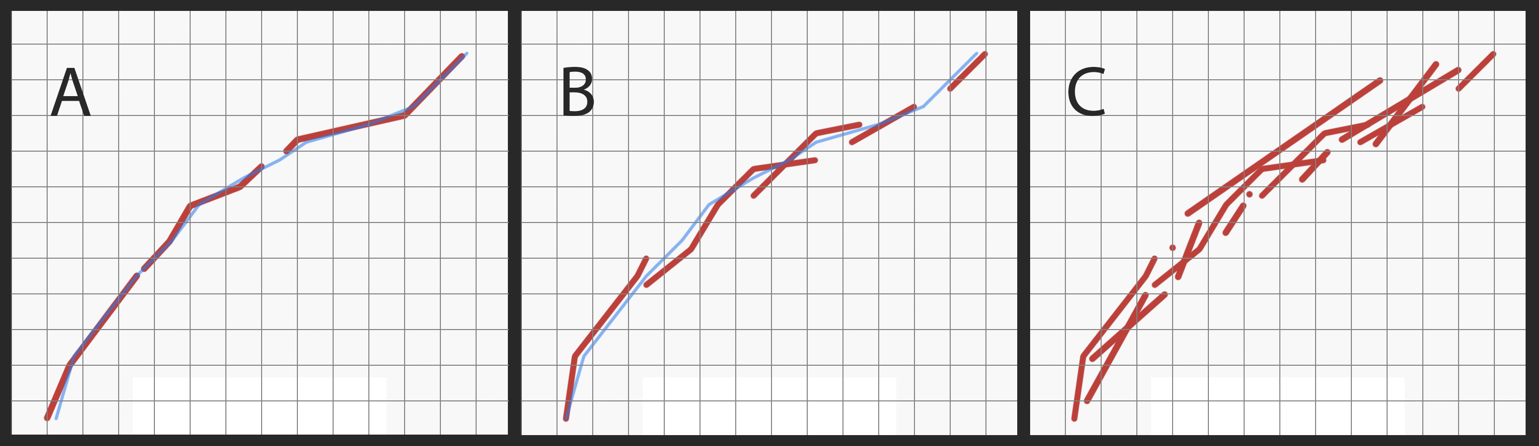
During development, I was provided with test data which was all nearly ideal (and ordered). No two SubRoutes overlapped, and each began near where the last one ended. I was able to simply append each line together to get one perfect line. The test data looked similar to Graph A in the attached image.
Now, Im looking at the real-world data and it looks more like Graph B, with the potential to look like Graph C or worse. Obviously, my previous approach won't work at all. Now I'm kind of stuck.
How would I take a group of lines, and create one composite line to represent the "average" (for lack of better words) of all of the lines? The blue line in Graphs A and B is what I am looking for.
Do you guys have any suggestions?
Bonus problem: After I find the composite line, I would like the take all the individual lines and change them to overlay the new composite line. I'm assuming the Snap tool is best for this?
Thanks for your time, I really appreciate any advice or suggestions!
J
- Mark as New
- Bookmark
- Subscribe
- Mute
- Subscribe to RSS Feed
- Permalink
buffer your polylines by a finite amount to collapse the inter-line space
convert the buffer to a centerline
Polygon To Centerline—Topographic Production toolbox | ArcGIS Desktop
good first start