- Home
- :
- All Communities
- :
- Industries
- :
- Transportation
- :
- Public Transit
- :
- Public Transit Questions
- :
- Re: Error when caching transit schedules
- Subscribe to RSS Feed
- Mark Topic as New
- Mark Topic as Read
- Float this Topic for Current User
- Bookmark
- Subscribe
- Mute
- Printer Friendly Page
- Mark as New
- Bookmark
- Subscribe
- Mute
- Subscribe to RSS Feed
- Permalink
Hi everyone.
I´m trying to set up a transit enabled Network Dataset. I used the Add GTFS to a Network Dataset Tool. So far it seems to have worked after getting rid of several errors during the process. Now as I wanted to use my network with the ArcMAP Network Analyst, the program always shows the following error Message: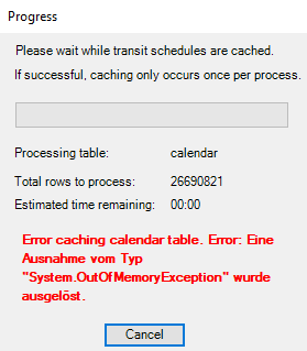
I excluded all the Network Locations except Streets_Use_This_one and enabled exclude restricted portions of the network. Also in the polygon generation tab i checked TransitLines and connectors as excluded sources.
What could be the reason for this to show up? And how can I prevent this error from happening?
Thanks to everyone, best regards, Tim
Solved! Go to Solution.
Accepted Solutions
- Mark as New
- Bookmark
- Subscribe
- Mute
- Subscribe to RSS Feed
- Permalink
As explained in my reply to your previous post, this tool is deprecated and no longer supported, so I cannot provide extensive assistance. The caching error in your screenshot above shows "OutOfMemoryException", which to me indicates that your computer is out of memory. There really isn't anything I can do to help you with that. It seems like your transit network is simply too large for ArcMap's memory resources to handle. ArcMap is a 32-bit application that cannot make use of your computer's full memory resources (so getting a better computer will not help). You could install ArcGIS Server and register the transit evaluator with Server, and that might fix it.
It would probably be easier at this point to just install ArcGIS Pro and use the newer, better functionality included out of the box there. This tutorial shows you exactly how to create a transit-enabled network in Pro: Create and use a network dataset with public transit data—ArcGIS Pro | Documentation
- Mark as New
- Bookmark
- Subscribe
- Mute
- Subscribe to RSS Feed
- Permalink
Thank you for your response again.
I was afraid that this was the reason. In fact my ND is quite huge, it contains transit information for most of germany. Is it possible to clip down the input feature classes for the network to only my area of interest? It is only a tiny fraction of the whole country and would greatly reduce the data size.
Would the transit schedule information get lost in the clipping process or are they stored anywhere else in the gdb than the TransitLine shapefile itsself? I have tried this allready, but the resulting network produces the same wrong results as the network I created following your (truely helpfull!) turorial. In my other question post, I have added a screenshot showing the strange output. So I can´t find out if the cliping process made the network malfunctioning or if there is another reason for that...
I think this will be my last try to make the ND work, otherwise I´ll have to switch to ArcGIS Pro.
- Mark as New
- Bookmark
- Subscribe
- Mute
- Subscribe to RSS Feed
- Permalink
The transit schedules are stored in a sqlite database, and that's what's being cached. Clipping the transit lines will have no effect.
You should really use ArcGIS Pro. My team put in a great deal of time and effort making that solution work better, faster, and more reliably than the old Add GTFS To A Network Dataset toolbox. You should use it in order to get the latest and best functionality with less likelihood of strange errors. Plus, I will be able to actually help you with your problems.
- Mark as New
- Bookmark
- Subscribe
- Mute
- Subscribe to RSS Feed
- Permalink
Ok, I now have confirmation from my university, that I will get ArcGIS Pro. I´ll give it a try and will come back to ask a few questions if necessary. Thank you very much so far!
- Mark as New
- Bookmark
- Subscribe
- Mute
- Subscribe to RSS Feed
- Permalink
Yay!!!! That is wonderful. Definitely let me know if you encounter any problems or if you have any suggestions for how we can improve the ArcGIS Pro solution.
- Mark as New
- Bookmark
- Subscribe
- Mute
- Subscribe to RSS Feed
- Permalink
Hi again,
I´ve been working with ArcGIS Pro for a while now. Unfortunately the step to snap the Stops to my street data does not work. I´ve followed each step just as described in the tutorial (Create and use a network dataset with public transit data—ArcGIS Pro | Documentation )![]()
There seems to be a problem concerning parent stations, as far as I can tell from the error message. Any suggestions, what could cause these?
- Mark as New
- Bookmark
- Subscribe
- Mute
- Subscribe to RSS Feed
- Permalink
Hi Tim. I'm sorry you've had so much trouble with this entire workflow. That's a pretty weird error.
In the line that failed, the tool's code is trying to retrieve the geometry of one of the stops, and for some reason the geometry is null. Theoretically this should never happen, but somehow it has happened anyway. This tells me that something is wrong with the Bamberg\Stops feature class. At least one of the points is somehow missing geometry.
Did you make any edits to the Stops feature class after you ran the GTFS To Network Dataset Transit Sources tool? Theoretically it should be impossible for that tool to output invalid stop geometries.
Or does your feature dataset have an unknown coordinate system? If you run Repair Geometry on the Stops feature class, does it fix anything?
- Mark as New
- Bookmark
- Subscribe
- Mute
- Subscribe to RSS Feed
- Permalink
No, I left the Stop data just the way the GTFS to network dataset transit sources output them. My spatial Reference for Stops is WGS 1984. I ran the project tool for my street data to match the Coordinate System.
The Repair Gemoetry Tool deleted 3 entries without geometry. After that, the Connect ND transit sources to streets worked. Thank you very much again!
In the next step, I´ll set up the network, let´s hope it works 
- Mark as New
- Bookmark
- Subscribe
- Mute
- Subscribe to RSS Feed
- Permalink
That's very weird that any stops ended up without geometry, but I'm glad you're back up and running.
Are you able to share your GTFS dataset with me? I'd like to run some tests on it to see if I can figure out how it got messed up in the first place.