- Home
- :
- All Communities
- :
- Industries
- :
- Transportation
- :
- Public Transit
- :
- Public Transit Questions
- :
- Re: Add GTFS to Network Dataset keeps producing Er...
- Subscribe to RSS Feed
- Mark Topic as New
- Mark Topic as Read
- Float this Topic for Current User
- Bookmark
- Subscribe
- Mute
- Printer Friendly Page
Add GTFS to Network Dataset keeps producing Error 999999 Topo-Engine
- Mark as New
- Bookmark
- Subscribe
- Mute
- Subscribe to RSS Feed
- Permalink
Hi everyone,
I´m using the Add GTFS to a Network Dataset Tool. I have completed the tutorial presented on Yotube with the provided Data and it worked just fine. However if I try to reproduce this using my own Network and GTFS Data fromGermany, the trouble beginns.The first step to gernerate Transit Lines and Stops is working well. But at the second step, trying to generate Stop-Street-Connectors, I keep recieving Error 999999 Topo-Engine (see attached file). Has anyone ever experienced this kind of error and has found any solution? Would greatfully accept any hints and ideas, as I really urgently need to fix this for my masters thesis.
Tanks in Advance, Tim
Solved! Go to Solution.
Accepted Solutions
- Mark as New
- Bookmark
- Subscribe
- Mute
- Subscribe to RSS Feed
- Permalink
Hi Tim. I cannot provide extensive support for this tool because it is now deprecated. The functionality is available out-of-the-box in ArcGIS Pro, so if at all possible, I encourage you to use that instead. It may make your problem simply go away.
With that said: The error message appears to be related to some problem with the geometry of your street features. I suggest you run the Check Geometry and Repair Geometry tools on your streets and then try running Step 2 again.
- Mark as New
- Bookmark
- Subscribe
- Mute
- Subscribe to RSS Feed
- Permalink
Hi Melinda,
thanks a lot for your fast reply! I´ve been running the Check Geometry and Repair Geometry Tools. They found one incident, where a Null-Geometry has been found. After fixing (deleting) the flawed object, I re-ran the second step, but still the same error-massage was given.
Oddly, while receiving the error-message, the stops_snaped2street points have been created for each individual stop from my GTFS file. Is it possible, that despite the error, the calculation was still sucessful, so that i can go on with producing the transit enabled network?
Best regards, Tim
- Mark as New
- Bookmark
- Subscribe
- Mute
- Subscribe to RSS Feed
- Permalink
The answer is maybe. The error message you posted earlier showed that it failed when running the Integrate tool. The purpose of that tool is to create a vertex in your streets at the location where each Stops_Snapped2Streets point intersects the street. Without these vertices, the network dataset will not actually be connected at those locations, so a traveler would not be able to get on or off the transit line at that location. It could be that just one or two locations caused a problem and the rest worked correctly, in which case the overall errors in your network would be small. On the other hand, possibly the Integrate tool did not add any vertices, in which case your transit lines will be completely disconnected from your streets.
- Mark as New
- Bookmark
- Subscribe
- Mute
- Subscribe to RSS Feed
- Permalink
I got the process working now. I clipped my original street data to the area I´m interested in, ran check geometry, fix geometry and integrate. None of these caused any issues.
Then Iset up my Network Dataset, wich also seemed to work. But executing step 3 to get the E-IDs, ArcGIS gave the attached error message. 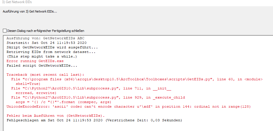
Is this a known issue and is there an (easy) fix available?
- Mark as New
- Bookmark
- Subscribe
- Mute
- Subscribe to RSS Feed
- Permalink
The error message itself refers to Unicode and ascii. It suggest you may have some non-ascii text characters in some of your data, that subsequently cause an issue when part of the processing pipeline you are using tries to handle this. E.g. you can't represent a Chinese character in ascii.
So, are there any special language specific characters in your data? If so, maybe replacing them by safer ascii text characters only solves the issue.
- Mark as New
- Bookmark
- Subscribe
- Mute
- Subscribe to RSS Feed
- Permalink
Thank you very much! I moved all the data files involved to another directory and now it has worked. Seems like the tools didn´t like them.
Now I have a Network Dataset, but the analysis keep producing strange results.
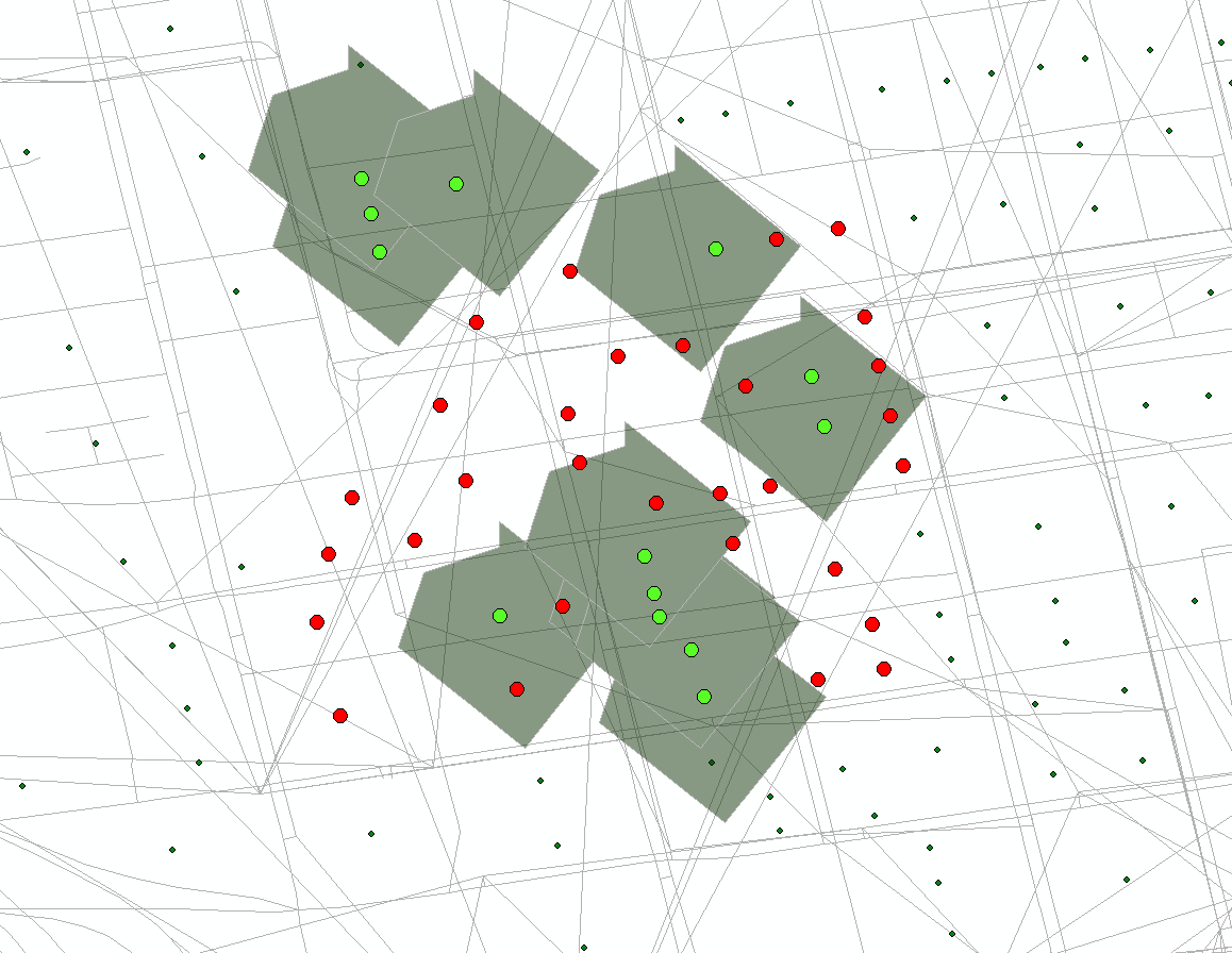
1) When creating service areas, each individual Polygon is shaped the same. This occurs for my own network aswel as for the network created from the provided Cincinnati data...
2) A lot of my points of interest wont be located onto the ND when processing service area calulations. I found its allways the ones, who are located closest to transit lines. But i have excluded them in my analysis settings, just as Melinda has shown in her tutorial on YouTube
Is there anythin I might have forgotten about? Thanks in advance