- Home
- :
- All Communities
- :
- Products
- :
- Oriented Imagery
- :
- Oriented Imagery Questions
- :
- Unable to load Oriented Imagery in Map Viewer/Indo...
- Subscribe to RSS Feed
- Mark Topic as New
- Mark Topic as Read
- Float this Topic for Current User
- Bookmark
- Subscribe
- Mute
- Printer Friendly Page
Unable to load Oriented Imagery in Map Viewer/Indoors
- Mark as New
- Bookmark
- Subscribe
- Mute
- Subscribe to RSS Feed
- Permalink
Greetings. I'm trying to add indoor photos to Oriented Imagery in ArcGIS Online. The images are 360-degree .jpgs that are taken indoors.
I've used the tutorial and the tools available in Pro, using the OI Toolbox (https://pro.arcgis.com/en/pro-app/latest/tool-reference/oriented-imagery/an-overview-of-the-oriented...). When I get the featureservice in to a Map Viewer in ArcGIS Online the OI tool loads and I can click to look at images. This is where trouble starts. The images does not seem to load. I get an error like "Error occurred while loading the image. Unable to load" and the URL to the image.
I've tried everything when it gets to hosting images Azure Blob, Amazone S3 and adding them as an attachement directly. If I click on the link it opens fine in the browser from all the sources. So I thought that there might be something off with the images themselfs, but they work fine in an Oriented Imagery Catalog (created the old way with the downloadble toolbox) and are viewable in Experience Builder using the widget. OIC are not supported in Indoors, where we're going to use this.
The images are about 30 mb. I've added one to AGOL (as it's to big to share here) https://geodata.maps.arcgis.com/home/item.html?id=2350554ed198448e90c7b9c81486c5b1 as well as the oriented imagery table from Pro (some of the values like heading are not "real" yet) and the error from the OI tool in map vierwer. All help to solve this would be great! Thanks!
- Mark as New
- Bookmark
- Subscribe
- Mute
- Subscribe to RSS Feed
- Permalink
The 360 image you shared does not have the GPS data to display the image on the map.
So I added a random latitude and longitude to the Oriented imagery table (attached) I created to add the image to the OI Dataset.
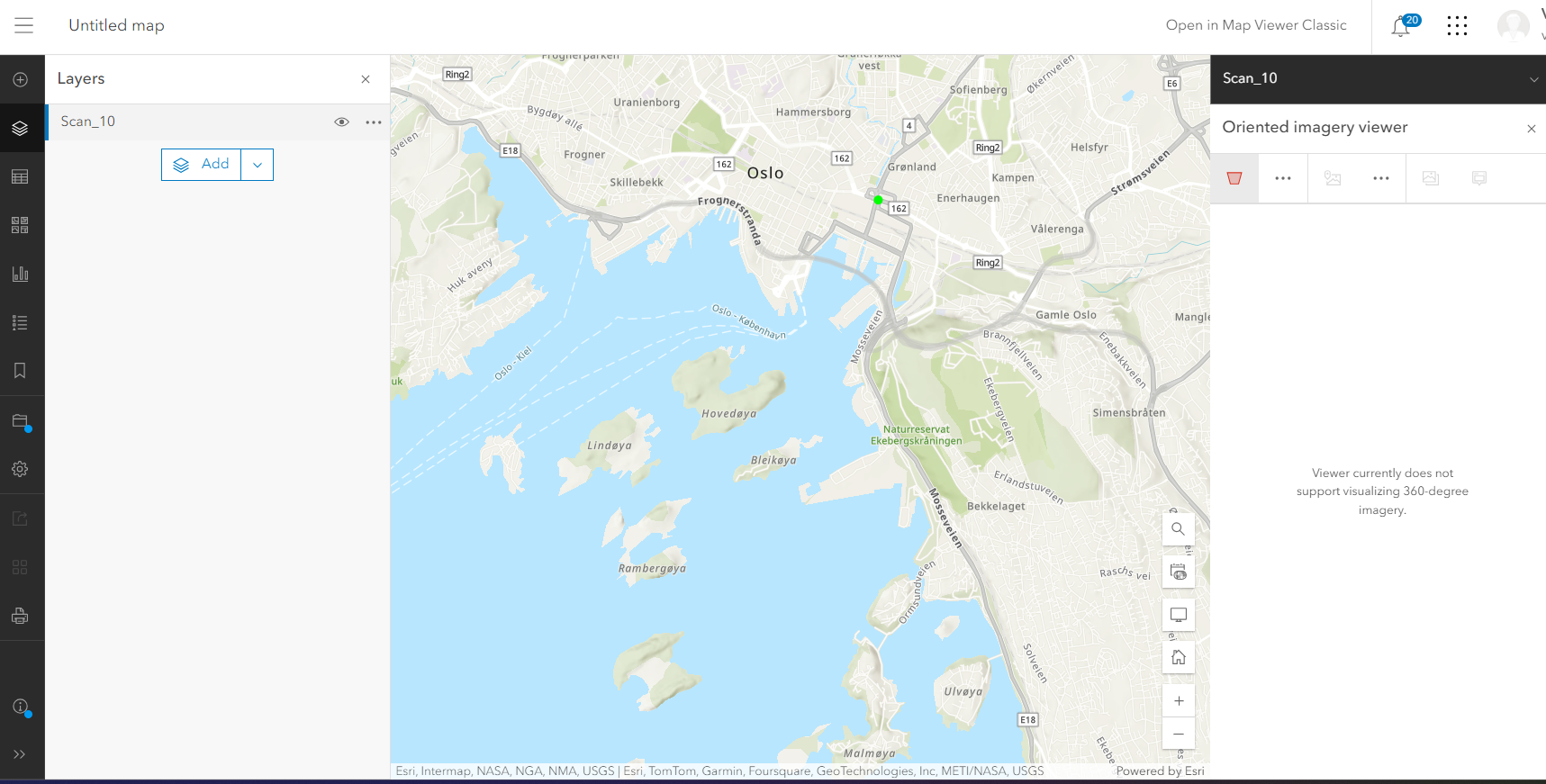
Unfortunately, I got this message when I tried to use OI tool in map viewer to visualize the image:
"Viewer currently does not support visualizing 360-degree imagery."
See the attached screenshot.
The interesting thing here is that the last release of OI supports equirectangular 360 images stored as JPEG. Here is a sample created by the ESRI team: https://www.arcgis.com/home/item.html?id=77c6a23d0dec4976a5ba0a8d7838c64f
- Mark as New
- Bookmark
- Subscribe
- Mute
- Subscribe to RSS Feed
- Permalink
I forgot to mention that there are no metadata in the image itself. I got the X and Y and camera properties in a separate CSV table. Weird that you got a different error than me, and as you say it should be supported i ArcGIS Online by now. I'm looking to find if there is any specification to how the image properties should be, other than jpg.
Thanks, Birk
- Mark as New
- Bookmark
- Subscribe
- Mute
- Subscribe to RSS Feed
- Permalink
We are having the same issue with images as attachments:
"Viewer currently does not support visualizing html 360-degree imagery."
Following along with this thread for any solutions.
- Mark as New
- Bookmark
- Subscribe
- Mute
- Subscribe to RSS Feed
- Permalink
Another option is to use the 360° photo and video Experience Builder widgets that can be found in the Esri Marketplace:
- Site Viewer 360 for ArcGIS: https://www.esri.com/en-us/arcgis-marketplace/listing/products/3ef6776bc0a24f7faca7aa6985954d8b
- Vidgeo for ArcGIS: https://www.esri.com/en-us/arcgis-marketplace/listing/products/6cd2d165020c4b63a1e9ba5830f88c85

- Mark as New
- Bookmark
- Subscribe
- Mute
- Subscribe to RSS Feed
- Permalink
have you gotten this to work yet @BirkSlipersæter1 ?
360 degree photos are now supported in ArcGIS Indoors.
I also shared some steps for getting 360 images into Indoors Mobile 2.0 without a 360 degree camera here.
- Mark as New
- Bookmark
- Subscribe
- Mute
- Subscribe to RSS Feed
- Permalink
Thanks @ToddW_stl . Didn't get it to work in Indoors, but made a workaround with experience builder. Great that it's now supported.