- Home
- :
- All Communities
- :
- Industries
- :
- Science
- :
- Ocean Science
- :
- Ocean Science Blog
- :
- What you will discover at the Ocean GIS Forum: Why...
What you will discover at the Ocean GIS Forum: Why (and How) We Map the Ocean
- Subscribe to RSS Feed
- Mark as New
- Mark as Read
- Bookmark
- Subscribe
- Printer Friendly Page
So you’ve been seeing the ads and the emails for the 2018 Esri Ocean GIS Forum, and you’re wondering just what you will gain and experience in coming? The brief answer has several key components; the Tuesday Workshops, the Wednesday Plenary and Keynote Presentation, the Thursday Technical Plenary, the User Presentations and Lightning Talks throughout Wednesday and Thursday, and a few additional special presentations. Most important however, are the people that glue all of these components together; the conversations, networking and reuniting of this small and intimate gathering is what makes it so valuable. You will experience days at Esri Headquarters, with access to your marine and oceanographic peers, as well as to the Esri staff that create, use, and support the scientific tools and processes presented at the Ocean Forum.
The Workshops. Valuable new knowledge will be gained by attending the Workshops on Tuesday, November 6, presented directly from the product managers and developers who create ArcGIS and the related apps we are featuring. With six workshops to choose from, you will surely find a topic of interest, and they are all included with the price of registration.
The Plenary. On Wednesday after the traditional Hawaiian Protocol Opening, Esri Founder and President Jack Dangermond will provide a welcome and overview of what Esri has been creating for ocean and atmospheric ocean science, and you will be the first to peak at advances and future capabilities. Following that, Dr. Timothy Hawthorne will share his experiences and observations from his extensive field research with new components of the ArcGIS platform, and he will reflect on the influences of government science, commercial operators, and start up companies on where the technology is headed. Esri Chief Scientist Dawn Wright and Dr Roger Sayre of the USGS will also present an update on the new Ecological Coastal Units Project.
User Presentations. Wednesday and Thursday afternoons we have approximately 40 scientific papers from our user community who will be presenting a mix of 15 minute papers, and 10 minute Lightning Talks. The diverse mix of topics in these presentations, from an equally diverse group of agencies, institutions and organizations, represent the state of best practices of Ocean Science and Ocean GIS. The sharing and discussion that occurs in this context lifts the community and speeds our forward progress together.
The Technical Plenary. On Thursday November 8th, we will start the day with the Technical plenary, a 90-minute venue for Esri scientific and development staff to share the brand-new tools and techniques that have been created over the last year to support multidimensional analysis, 3-D interpolation, seafloor contouring, and more. We proudly demonstrate creative new methods and tools for research and analytics using publicly available content from the Living Atlas, and off the shelf, current software. The Tech Plenary is always the inspiring technical highlight of the Ocean Forum. Following the Tech Plenary this year, we will have a session of user experiences and other new information. These presentations will include Marine Protected Area work from NOAA and their partners, it will include work from our sponsors on semi real-time bathymetry collection and processing directly into ArcGIS information products, as well as other announcements of soon to be released functionality.
Our theme this year is Why (and How) We Map the Ocean. We will close The Forum with a community that is connected and informed, as well as individuals who will return home with new ideas and new inspiration. We at Esri get to hear from you what you’re working on and what you need from us. The Ocean Forum has always been primarily about building a community for sharing GIS tools and techniques in these exciting and challenging times. With a rapidly expanding array of data collection hardware, it is critical to share with one another Why and How We Map the Ocean. Looking forward to seeing you there!
Join the GeoNet Community and Follow the Ocean Sciences GIS group
Before, during and after the conference we'll be connecting, collaborating and sharing updates in the Ocean Sciences group on the GeoNet, Community. We invite you to join and contribute to the conversations.
If you're not already a member of the GeoNet Community, follow these instructions:
- If you don't already have an existing Esri account, click here to create your GeoNet and Esri account.
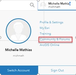
- If you already have an existing Esri account, go to the Esri.com drop down (see image below), sign in and click on "Community & Forums" to activate your GeoNet account.
You must be a registered user to add a comment. If you've already registered, sign in. Otherwise, register and sign in.