- Home
- :
- All Communities
- :
- User Groups
- :
- New to GIS
- :
- Questions
- :
- exporting mxd file as pdf and missing image data
- Subscribe to RSS Feed
- Mark Topic as New
- Mark Topic as Read
- Float this Topic for Current User
- Bookmark
- Subscribe
- Mute
- Printer Friendly Page
exporting mxd file as pdf and missing image data
- Mark as New
- Bookmark
- Subscribe
- Mute
- Subscribe to RSS Feed
- Permalink
Darren,
Thanks for your quick reply and sorry it's taken so long to get back to you, I tried "export map..." in the file menu and switched the DPI to 2500 (any larger and my computer won't handle it) and then opened it two different programs and the lines of the county as well as the labels of the counties are still far too light. Do you have any other ideas that I could try?
Thanks
Michael
- Mark as New
- Bookmark
- Subscribe
- Mute
- Subscribe to RSS Feed
- Permalink
You may want to check the export settings from ArcMap. There are several that affect the output, and some are not so obvious.
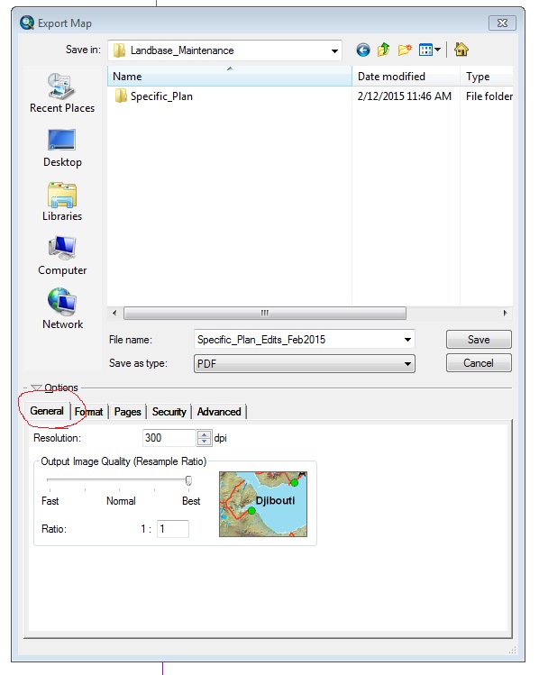
First, when you export, check that the options are visible. If you don't see them, click on the triangle to open them.
Next, on the "General" Tab, check the "Resolution" and "Output Image Quality". You'll have to play with the settings a bit to find what works best, but a good starting point is "Resolution" of 300 and "Output Image Quality" of Best.
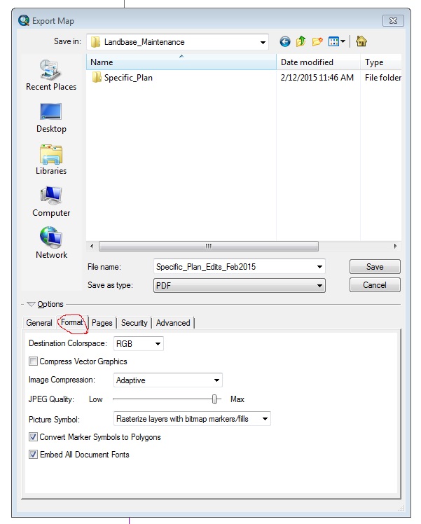
Next, check the "Format" Tab. The "Image Compression" has several flavors to try. For the "JPEG Quality" setting, I would suggest "Max". There are several possibilities for "Picture Symbol" to try out. I would recommend in most cases that you have both of the checkboxes checked.
Again, you will likely have to experiment with the settings a bit to find what works. In general, going for high quality will lead to a huge file and going for a small file leads to poor quality - the trick is to find a balance that works. For your specific case, hopefully this means by tinkering with one or more of these settings you get the linework and fonts to portray as you expect.
Chris Donohue, GISP
- Mark as New
- Bookmark
- Subscribe
- Mute
- Subscribe to RSS Feed
- Permalink
Chris,
I've attached two files, with my exporting it only gives me two options under the "options" category, the first is General and the second is Format. I'm not sure which version of ArcMap you're using but I'm using Version 10.2, and as I stated previously I already messed with the resolution of the pixels all the way up to 2500 dpi. Seems this is a problem that keep alluding me.
If you have any other ideas please let me know.
thanks
Michael