- Home
- :
- All Communities
- :
- User Groups
- :
- New to GIS
- :
- Questions
- :
- Cadastre definitions
- Subscribe to RSS Feed
- Mark Topic as New
- Mark Topic as Read
- Float this Topic for Current User
- Bookmark
- Subscribe
- Mute
- Printer Friendly Page
Cadastre definitions
- Mark as New
- Bookmark
- Subscribe
- Mute
- Subscribe to RSS Feed
- Permalink
2.2. Cadastre
2.2.1. Cadastre definition
2.2.1.1. Before 1995 FIG Statement
At Commission 7 Opening Address at the 1990 FIG Congress a set of clear and concise cadastral definitions were presented, as follows (Henssen & Williamson, 1990):
- Land Registration: is a process of official recording of rights in land through deeds or as title (on properties). It means that there is an official record (the land register) of rights on land or of deeds concerning changes in the legal situation of defined units of land. It gives an answer to the questions "who" and "how";
- Cadastre: is a methodically arranged public inventory of data concerning properties within a certain country or district, based on a survey of their boundaries. Such properties are systematically identified by means of some separate designation. The outlines or boundaries of the property and the parcel identifier are normally shown on large-scale maps, which, together with registers, may show for each separate property the nature, size, value and legal rights associated with the parcel. It gives an answer to the questions "where" and "how much";
- Land recording:
- land registration and cadastre usually complement each other; they operate as interactive systems. Land registration puts, in principle, the accent on the relation subject-right, whereas cadastre puts the accent on the relation right-object. In other words: the land registration answers the questions as to who and how the cadastre answers the questions as to where and how much;
- because land registration and cadastre ("who and how" along with "where and how much") complement each other, the terms "land recording" or "land records" are usually used to indicate these two components together as a whole. Often the term "land titling" is used instead of the term "land recording".
In the previous cited work (Henssen & Williamson, 1990) it´s also concluded that an adequate land recording system (being a land registration system and a cadastre) consists of two basic parts:
- A descriptive part containing registers or files which record legal facts (deeds) or legal consequences (titles) and other physical or abstract attributes concerning the parcels depicted on the maps described below;
- A cartographic part, consisting of (large scale) maps, based on a survey, which contain the division into parcels of an area and with appropriate parcel identifiers.
Finally, (Henssen & Williamson, 1990) stated that, depending often on the author's discipline (e.g. lawyer, land surveyor or layman) and country of origin:
- the words land registration and cadastre are also used to indicate the organisational unit, which operates in the concerned field of recording;
- the word land registration concerns only the system of registration of title (English influence);
- land registration covers also the cadastral system;
- cadastre includes also land registration (e.g. in "legal cadastre" or "multipurpose cadastre").
2.2.1.2. FIG Statement on the Cadastre
A cadastre is normally a parcel based, and up-to-date land information system containing a record of interests in land (e.g. rights, restrictions and responsibilities). It usually includes a geometric description of land parcels linked to other records describing the nature of the interests, the ownership or control of those interests, and often the value of the parcel and its improvements. It may be established for fiscal purposes (e.g. valuation and equitable taxation), legal purposes (conveyancing), to assist in the management of land and land use (e.g. for planning and other administrative purposes), and enables sustainable development and environmental protection (FIG, 1995).
This definition frames the so called conventional LA systems which are based on the ‘parcel-based’ approach.
2.2.1.3. A wider inclusive view
According to (Augustinus, 2010) the greatest challenges to any country's cadastral system are the informal settlements. By 2030 the urban population of all developing regions, including Asia and Africa, will far outweigh the rural. This massive shift towards urbanisation over the next twenty years will be characterised by informality, illegality and unplanned settlements. Urban growth will be associated with poverty and slum growth. Today about one third of urban residents in the developing world live in slums which either lie outside the cadastre or the occupation of which does not match it.
The land industry needs rather to be developing appropriate tools for users across the spectrum, including the poor, women and men, and in different regions of the world, not just for the developed world. So, what needs to be developed is a pro-poor land-administration system (LAS) of completely different design, interoperable with current cadastral systems (Augustinus, 2010). This technical gap needs to be filled for a range of purposes, including:
- forest management;
- wetland management outside the register;
- customary tenure with layers of group rights;
- informal settlement inventory in preparation for upgrading;
- large-scale identification of land rights and claims following natural disaster, including multiple households inhabiting same dwelling unit, as a pre-cadastral step;
- development of claims database in post-conflict environments, including overlapping claims.
In this context, alternative representations of area’s and alternatives for traditional land surveys are needed. Traditional land surveys are costly and time consuming, and proved not to work in many situations in developing countries. Handheld GPS, or the use of satellite imagery, are considered to be inaccurate by the surveyor’s community; but this attitude results in a lack of LA coverage. There is a need for complete and up-to-date LA coverage. A more flexible system has to be based on a global standard like LADM, and it has to be manageable by the local community itself. It is here where the Social Tenure Domain Model (STDM) comes in. This kind of standardization allows for the integration of data collected by communities into a formal LA system at a later moment in time (Uitermark, et al., 2010).
Furthermore, and according to (Roberge, 2010) developing countries, where the need for land-rights infrastructure is primary and resources are scarce, require light and low-cost solutions creating exact rather than accurate data.
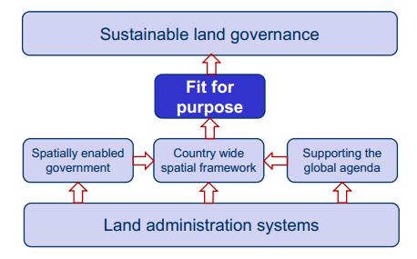 Figure 14 - A fit-for-purpose approach (Enemark, 2012)
Reinforcing this idea, (Enemark, 2013) framing cadastre as the core engine for spatially enabled land administration, states that spatial enablement is not primarily about accuracy: it is about adequate identification, completeness and credibility. Systems should be built using a “fit for purpose‟ approach (presented in Figure 14) while accuracy can be incrementally improved over time when justifying serving the needs of citizens and society. In relation to the concept of the continuum of land rights such a fit for purpose approach could then be referred to as a “continuum of accuracy‟.
A final reference to “The Continuum Paradigm” concept (Teo, 2012), that is framed and extends the “Land Rights Continuum” (UN-HABITAT, 2011) (UN-HABITAT, 2012a) (Teo, 2012b) notion to broader aspects of land systems, compose by a Continuum of Approaches (from less to more rigorous), a Continuum of Technology (from less to more sophisticate), a Continuum of Measurement (from less to more precise); and a Continual Tools Development (from complex to greater complexity) as shown in Figure 15. Therefore, (Teo, 2012) states that this would be the only way to build land systems, especially in developing countries, in order to address the realities of different sections of society.

Figure 15 – The Continuum Paradigm (Teo, 2012)
PS: This text is extracted from my Master's Thesis in GIS and Science (published at RUN: The implementation of an Enterprise Geographical Information System to support Cadastre and Exp... ) Dissertation's State of Art Chapter 2.
Bibliography
Augustinus, C., 2010. Towards Cadastre 2034: Part II. Accuracy No Solution.[Online]
Available at: http://www.gim-international.com/issues/articles/id1604-Towards_Cadastre__Part_II.html
[Accessed 04 03 2014].
Enemark, S., 2012. Sustainable Land Governance: Three Key demands. [Online]
Available at:http://www.fig.net/pub/fig2012/ppt/ts03a/TS03A_enemark_5998_ppt.pdf
[Accessed 05 03 2014].
Enemark, S., 2013. FIT FOR PURPOSE: Building Spatial Frameworks for Sustainable and Transparent Land Governance. [Online]
Available at:http://vbn.aau.dk/files/77941985/Washington_2013._Paper._Enemark._WB_Land_and_Poverty_Conf._docx.pdf
[Accessed 05 03 2014].
FIG, 1995. FIG Commission 7 Statement on the Cadastre. [Online]
Available at:www.fig.net/commission7/reports/cadastre/statement_on_cadastre.html
[Accessed 15 07 2014].
Henssen, J. & Williamson, I., 1990. Land Registration, Cadastre and its Interaction - A World Perspective. [Online]
Available at:http://www.csdila.unimelb.edu.au/publication/misc/anthology/article/artic5.htm
[Accessed 03 03 2014].
Roberge, D., 2010. Towards Cadastre 2034: Part II. Time Will Tell. [Online]
Available at: http://www.gim-international.com/issues/articles/id1604-Towards_Cadastre__Part_II.html
[Accessed 04 03 2014].
Teo, C., 2012b. News 2012 - FIG, 6th World Urban Forum. Global Land Tool Network Roundtable. [Online]
Available at:http://www.fig.net/news/news_2012/wuf6_sep_2012/fig_wuf6_gltn_roundtable_sep_2012.pdf
[Accessed 10 03 2014].
Teo, C., 2012. Improving Land Governance on a Broad Basis: Professional’s Role.[Online]
Available at:http://www.landandpoverty.com/agenda/pdfs/ppt/cheehai_powerpoint.pdf
[Accessed 09 03 2014].
Uitermark, H., Van Oosterom, P., Zevenbergen, J. & Lemmen, C., 2010. From LADM/STDM to a Spatially Enabled Society: a Vision for 2025. [Online]
Available at: http://repository.tudelft.nl/view/ir/uuid:be7833ff-8908-4aa4-bd45-0d0ddd56c0c8/
[Accessed 04 03 2014].
UN-HABITAT, 2011. Proceedings of the Governing Council of the United Nations Human Settlements Programme at its twenty-third session. [Online]
Available at: http://www.uncsd2012.org/content/documents/UN-Habitat%20Resolution%20on%20Rio+20.pdf
[Accessed 09 03 2014].
UN-HABITAT, 2012a. WORLD URBAN FORUM 6. ROUNDTABLE OF GLOBAL LAND TOOL NETWORK. [Online]
Available at: http://www.unhabitat.org/downloads/docs/WUF6-Roundtable9-GlobalLandToolNetwork.pdf
[Accessed 10 03 2014].