- Home
- :
- All Communities
- :
- Industries
- :
- Nat Mapping & Charting Authorities
- :
- Nat. Mapping & Charting Blog
- :
- Future Impacts by AI on Mapping and Modernization
Future Impacts by AI on Mapping and Modernization
- Subscribe to RSS Feed
- Mark as New
- Mark as Read
- Bookmark
- Subscribe
- Printer Friendly Page
Future Impacts by AI on Mapping and Modernization
Authored By: Steve Snow
Esri Senior National Government Industry Strategy Specialist

Part 1 of a 7 part series exploring GIS and Artificial Intelligence
We are now living in an age where technology is the backbone of successful mapping organizations. By embracing technology all parts of the workplace have become more productive when working on projects. Geospatial organizations have continuously improved upon production and analysis processes by introducing automation and new technologies to the workforce. An exciting recent addition to automation has been the adoption of Deep Learning (DL) by the GIS industry, resulting in a vast sub-domain called Geographic Artificial Intelligence (GeoAI). These new technologies, when paired with human operators, are ushering in new exciting capabilities that were previously thought as science fiction in the past.
The term Artificial Intelligence (AI) was first introduced by Professor John Mcarthy in 1955. Due to lack of computational power and large publicly available data sets the field of AI grew slowly. All of this started to change with the development and growth of the internet. With the creation of the internet large amounts of publicly available data became available to develop AI training datasets. These datasets are necessary, because large amounts of data are needed to train AI models. Additionally, with the advent of the Graphical Processing Unit (GPU), affordable processing made possible accelerated development and use of AI.
Deep Learning (DL) is a subset of AI and mainly uses neural networks that are inspired by biological neural networks. DL is being used in many areas for quick decision making and patter recognition in such tasks as self-driving cars, speech recognition, robotics and image classification.
The most interesting development for Mapping modernization has been the evolution and intersection of GIS or Geospatial Technology with AI and DL. This intersection has provided some of the most powerful technology called GeoAI. Simply put, GeoAI is the intersection of GIS, AI, and Location.
The Importance of GeoAI and Why You Should Care
In all workplaces technology and modernization have drastically impacted work efficiency. Modernization has always been an ongoing process. With the development of electricity, typewriters, computers, GPS, Imagery, Lidar, Autonomous Robots, and GeoAI change in within the workplace has been the only constant. Because of change there is always a lag before any adoption. The hardest part to adapting to this change is the fear of becoming irrelevant and being replaced. Due to fear of replacement it’s often hard for workers to recognize the opportunities that new technology certainly brings. With GeoAI new opportunities for workers need to be recognized that will enhance knowledge and understanding which make the individual more competitive in the workplace. It’s important that by seizing this GeoAI opportunity workers can remove the risk of being left behind and take advantage of advanced placement in the workplace. One area that this is taking place is in the area of remote sensing.
GeoAI in National Mapping and Remote Sensing
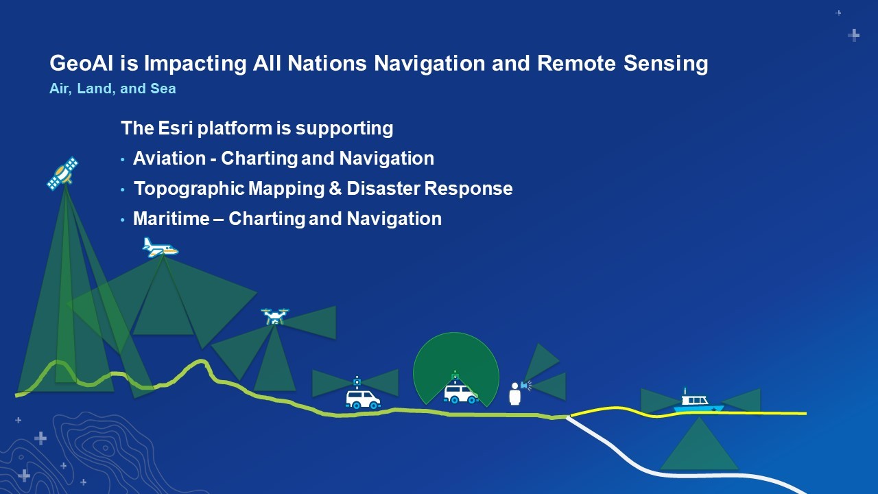
It’s important to note that mapping through earth observation is a difficult task. Earth Observation consists of multiple domains such as Air, Land, and Sea. GIS is the unifying technology that is needed for mapping large geographic datasets in national domains. A GIS platform is required that can support such things as Aviation, Topographic Mapping and Disaster Response at global and local scales, and also Maritime requirements for charting of the ocean’s bathymetry, water column, and littoral zones. One such technology that can do this is Esri’s ArcGIS Platform which provides the ability to utilize GeoAI for object detection and classification from both point clouds and raster surfaces derived from Remotely Sensed information. Many international organizations like the International Civil Aviation Organizations (ICAO) are partnering with industry to bring GeoAI into mainstream industries like aviation .
Read part 2 of the series - GIS, Artificial Intelligence, and Automation in the Workplace
You must be a registered user to add a comment. If you've already registered, sign in. Otherwise, register and sign in.