- Home
- :
- All Communities
- :
- Products
- :
- ModelBuilder
- :
- ModelBuilder Questions
- :
- Model performance issue
- Subscribe to RSS Feed
- Mark Topic as New
- Mark Topic as Read
- Float this Topic for Current User
- Bookmark
- Subscribe
- Mute
- Printer Friendly Page
Model performance issue
- Mark as New
- Bookmark
- Subscribe
- Mute
- Subscribe to RSS Feed
- Permalink
Hey everybody,
I am working on a Model in which you can use your current street centerline file and transform it into a NENA standard street centerline file. This includes having a lot of drop down boxes and check boxes. It seems the more drop down boxes and checkboxes I use, the more my model takes to respond.
I was wondering if anyone has any suggestions to enhance the performance?
Thanks,
Tim
- Mark as New
- Bookmark
- Subscribe
- Mute
- Subscribe to RSS Feed
- Permalink
I've had a look at your model, it's quite big! You have hit the limitation of model builder and it is creaking under a complex interface. When you change anything a whole load of validation is run behind the scenes which you have no control over.
There is really only 1 option here and that is to convert the entire model into python code, I suspect it will also run faster and you can organize it to be much more efficient.
With python you have two options:
- Develop it as a python script and then wire up an interface to it. This would be the easiest approach but could potentially lead to the same slow down.
- Develop it as a python addin toolbox and define a new interface for it. An obvious one is as you have a lot of repetition for similar like inputs a value table would be a better choice. Your user would complete the table then it is just ONE parameter that needs validating not the dozen you have now.
If you are not comfortable in programming in python then there are many developers out there who could do this for you but obviously for a fee.
- Mark as New
- Bookmark
- Subscribe
- Mute
- Subscribe to RSS Feed
- Permalink
Duncan,
great post! I have dabbled in Python Addins before and you are right this would be the best way to go. I just need to figure out how to in cooperate all the dropdown boxes that I need.
Tim
- Mark as New
- Bookmark
- Subscribe
- Mute
- Subscribe to RSS Feed
- Permalink
Tim:
That's a pretty intense model you have there. I can see why it is bogging down - Modelbuilder unfortunately is not known for speedy processes.
When you do get it worked out, some of us might bribe you for copy of the model/code. Like when the NENA standard finally becomes a mandatory requirement, me and this guy: jborgion 
Hope the coding goes well,
Chris Donohue, GISP
- Mark as New
- Bookmark
- Subscribe
- Mute
- Subscribe to RSS Feed
- Permalink
Here's a thought; if NENA is going to force it's standards upon PSAPs, the very least they can do is provide a little coin to help defray the development costs...
- Mark as New
- Bookmark
- Subscribe
- Mute
- Subscribe to RSS Feed
- Permalink
Of course I would share it!
For our data I have the street model finished already, but I thought it might be a good idea to create this customized model, so other agencies don't need to go through all the hassle.
- Mark as New
- Bookmark
- Subscribe
- Mute
- Subscribe to RSS Feed
- Permalink
You are a good man Tim Witt....
- Mark as New
- Bookmark
- Subscribe
- Mute
- Subscribe to RSS Feed
- Permalink
The obvious place to be sharing it would be http://codesharing.arcgis.com/ rather than say attached to a reply in this thread.
- Mark as New
- Bookmark
- Subscribe
- Mute
- Subscribe to RSS Feed
- Permalink
Agreed, that is a good website.
Thanks again for the python addin suggestion, it is so much faster.
This is how it will look like:
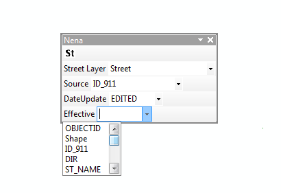
The only issue I need to solve is how to manipulate the layout because I will need 50!!!! combo boxes.
- Mark as New
- Bookmark
- Subscribe
- Mute
- Subscribe to RSS Feed
- Permalink
I have got my terminology mixed up, it is a python toolbox not a python addin I was thinking about, my apologies. The image above looks like a toolbar to me? Python Addins are more for interacting with the map window where you want to create a geo-processing tool.
So one can have python scripts, python addins or python toolboxes. I have developed more complex interfaces with using python toolboxes. I suggest you look at this document it shows you how to construct value tables.