- Home
- :
- Community Resources
- :
- Member Introductions
- :
- Introduce Yourself!
- Subscribe to RSS Feed
- Mark Topic as New
- Mark Topic as Read
- Float this Topic for Current User
- Bookmark
- Subscribe
- Mute
- Printer Friendly Page
Introduce Yourself!
- Mark as New
- Bookmark
- Subscribe
- Mute
- Subscribe to RSS Feed
- Permalink

Welcome to GeoNet!
We are a community that collaborates, learns and shares together. To help you connect with other members, we started this introduction thread. Think of this as your intro to GeoNet networking and a chance to get to know each other as we begin our GeoNet journey.
Please introduce yourself to the rest of the community by sharing your answers to the questions in the comments section below.
- Where do you work and what is your role?
- What GIS success have you had this year and what product did you use? (big or small - no win is out of bounds)
- What is your expertise (GIS related or not), and how can that help the community?
Bonus Round! Post the coordinates to your favorite place on earth.
note: this post has been archived, and is available in read only mode. To create a new introduction, please visit the new GeoNet Member Introductions space. Thank you!
Manager, Community Experience & Programs
- Mark as New
- Bookmark
- Subscribe
- Mute
- Subscribe to RSS Feed
- Permalink
- I work for Dominion Energy Ohio at a small office using Smallworld to map service lines for natural gas.
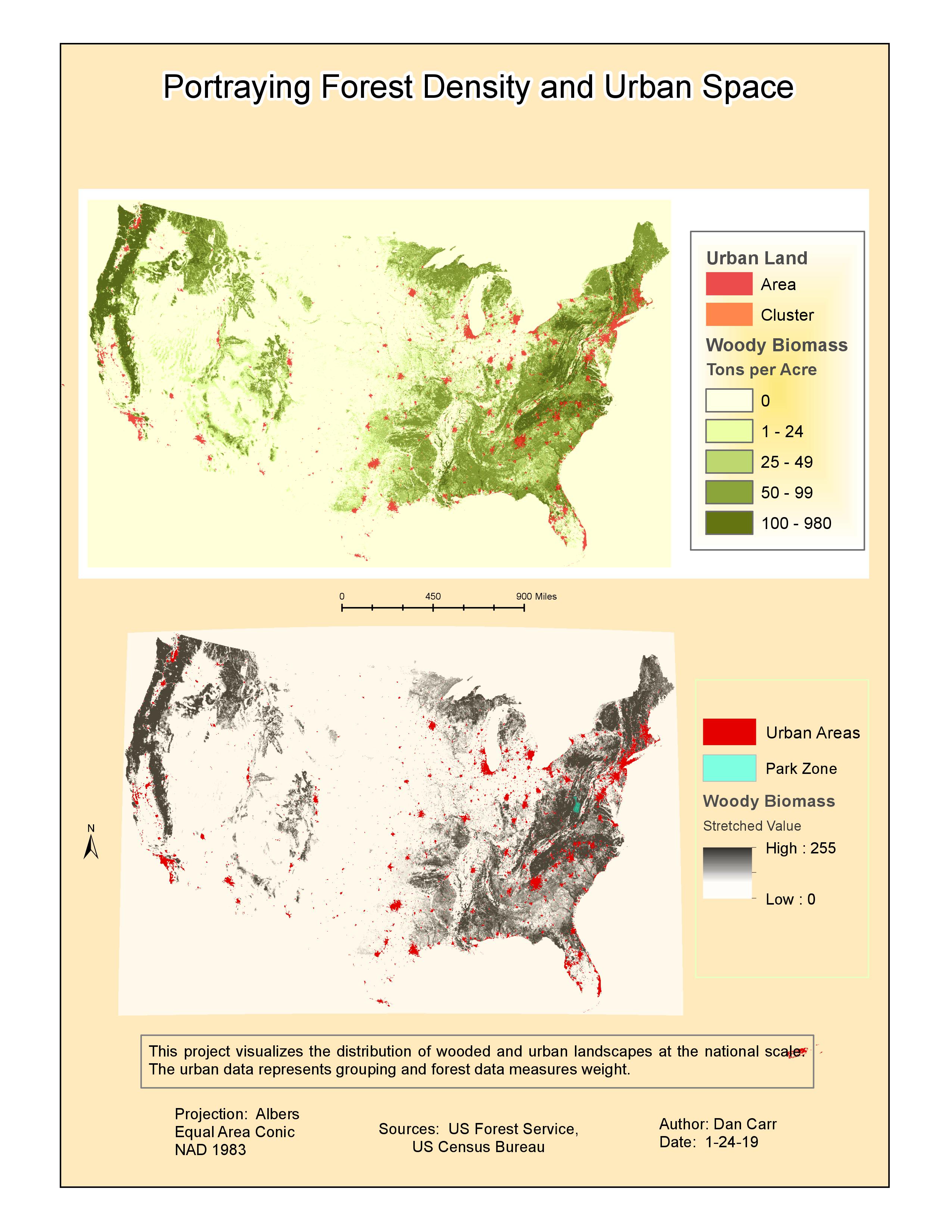
- I've mapped varied work methods from service line replacement on parcels to distribution updates in street projects. I've also expanded horizons with my own research of earth terrain ~ I made a series of maps with varied themes (earlier this year) based on data from the capstone project I did for a GIS certificate (last year). Here's a sample!
- For expertise, I'm well-rounded with mapping paper documents that come in from the field. I ensure lines are drawn, notes made, and natural gas objects are connected properly in the spatial database (GIS edits). I've also worked with DEMs (projects, analysis, maps) in ArcGIS included in correlating environment and thematic variables.
- BONUS: I wish I knew my favorite place.... I have a quest to determine this!
- Mark as New
- Bookmark
- Subscribe
- Mute
- Subscribe to RSS Feed
- Permalink
Welcome to GeoNet, Dan Carr!
Nice work on the terrain maps and congratulations on receiving your GIS certificate last year. Based on your background, here are some places in GeoNet you might find interesting:
I hope you take on the exciting challenge of finding your favorite place and sharing it back with us soon!
Cheers,
Leslie
- Mark as New
- Bookmark
- Subscribe
- Mute
- Subscribe to RSS Feed
- Permalink
Introduction: Marcus Idoko is my name
I got a job offer with DRC as a GIS Specialist recently and required to use ArcGIS Pro to support Humanitarian activities going on in a conflict zone, North East Nigeria.
I have started learning how to use ArcGIS Pro. As a Geomatics Engineering graduate the learning curve isn't going to be too steep, however I will appreciate any suggestions that will help me have a quick hang of the software.
I have just started with creation of projects. I had issues docking 2D and 3D side by side. I will go over that lesson again even though I got a certificate already.
I had issue creating the second project as it didn't work out like the first project I created. I must have missed out something, I am stock with Exporing Geodatabase. I need assistance
Thank you
- Mark as New
- Bookmark
- Subscribe
- Mute
- Subscribe to RSS Feed
- Permalink
Welcome to GeoNet, Marcus Idoko!
Congratulations on the job offer. For guidance on the projects that you mentioned, see these following places for questions you may have:
In the product spaces, you can ask specific workflow questions where you need guidance from the community to provide assistance and also follow those spaces to stay connected to discussions. If you need help with how to ask a question or other ways to engage the community for support, see our GeoNet Resource Hub for more information.
Cheers,
Leslie
- Mark as New
- Bookmark
- Subscribe
- Mute
- Subscribe to RSS Feed
- Permalink
Where do you work and what is your role?
I work for Innovyze, Inc. We make hydraulic modeling tools integrated inside the ArcGIS environment. I am the Global Lead for Strategic Partnerships and work closely with many of the other Esri Partners who are in the Water space.
What GIS success have you had this year and what product did you use?
As a company that makes engineering tools, our GIS success is in getting those tools out to the community for use by end users (Water, Sewer, Stormwater Utilities, Cities and other Municipalities and also the trusted Consulting Firms that work closely with them). Our InfoWater, InfoSWMM, and InfoSewer are staples in the industry and our more recent InfoAsset Planner helps solve the aging infrastructure issue that is hitting the US hard and that most of the rest of the world has had to deal with already.
What is your expertise (GIS related or not), and how can that help the community?
My background/expertise is ~35 years in the water space working originally as a consultant on master plan projects and then helping to found our company and to get ArcGIS based modeling tools out to the community.
- Mark as New
- Bookmark
- Subscribe
- Mute
- Subscribe to RSS Feed
- Permalink
Hi Erick Heath, Welcome to GeoNet!
Thanks for joining us in the community. Based on your experience, here are a few places you might be interested in checking out and following for discussions:
You can also find discussions on relevant products to your work in the Product Communities page. If you need any further assistance navigating the community, see our GeoNet Resource Hub.
Cheers,
Leslie
- Mark as New
- Bookmark
- Subscribe
- Mute
- Subscribe to RSS Feed
- Permalink
Good evening, I'm Giorgia. I joined your community to understand how to insert a 360vr photo in a story map
- Mark as New
- Bookmark
- Subscribe
- Mute
- Subscribe to RSS Feed
- Permalink
Hi Giorgia Padovani,
Welcome to GeoNet! I see you have found the place to post your question in ArcGIS StoryMaps. If you should need additional assistance from the community for other products, see Product Communities. For further assistance on finding your way around GeoNet, see our GeoNet Resource Hub.
Best wishes on your map! Hopefully, you can share with us how the creation of your StoryMap goes in a blog!
Cheers,
Leslie
- Mark as New
- Bookmark
- Subscribe
- Mute
- Subscribe to RSS Feed
- Permalink
Hi, My name is Bart Conard
- Where do you work and what is your role?
- I work in the oil and gas industry in the Southwest PA region as a Business Intelligence Developer.
- What GIS success have you had this year and what product did you use? (big or small - no win is out of bounds)
- We've used Survey 123 and had success. We're seeking to make greater use of ArcGIS GeoEvent Server and 'Verizon Connect' Connector
- What is your expertise (GIS related or not), and how can that help the community?
- I've had some short experience with gis mapping in the distant past. I'm seeking insight from the community in the use / combining of connectors: transports + adaptors), and processors to potentially process IIOT data from sensors in remote location on 'edge' devices to train modelling related to spatiotemporal and / or non-spatiotemporal data. I'm particularly interested if that may be an out-of-box, Esri, or partner processor?
- Mark as New
- Bookmark
- Subscribe
- Mute
- Subscribe to RSS Feed
- Permalink
Welcome to GeoNet, Bart!
Glad to hear about your success with Survey123 for ArcGIS! Here are some places to explore discussions about your topics of interest in the community:
There are additional ways you can find topics of interest. See these Product and Community pages to start:
Thanks for joining us!
Cheers,
Leslie