- Home
- :
- All Communities
- :
- Products
- :
- Mapping
- :
- Mapping Questions
- :
- Re: Problem displaying mosaic (greyed out)
- Subscribe to RSS Feed
- Mark Topic as New
- Mark Topic as Read
- Float this Topic for Current User
- Bookmark
- Subscribe
- Mute
- Printer Friendly Page
Problem displaying mosaic (greyed out)
- Mark as New
- Bookmark
- Subscribe
- Mute
- Subscribe to RSS Feed
- Permalink
Hello, I am writing about a seemingly simple problem. I am trying to create a mosaic of DEM files that are the "Disc Image File" format. I create an empty mosaic dataset in my geodatabase, run the add rasters to mosaic dataset tool, and use "Raster Dataset" as my file type (generic). And I check the "create overview" box. The resulting mosaic is grey at all scales despite its settings to display at all scales. I've tried multiple ways of creating this mosaic (including Append, Raster Catalog, Table data type, and the Mosaic tool), all with either grey or non-displaying results. However, the images display completely normally when added to ArcMap by themselves.
And I'll add that while I'm relatively new to GIS, I've tried just about everything I can find on ESRI and Google to resolve this issue. Also, I've successfully & easily created mosaics out of TIFFs so I'm familiar with the workflow but perhaps I'm just missing some particular setting. The DEMs each perhaps a square quarter mile in area and about 20 MB in data size.
Thanks for reading.
- Mark as New
- Bookmark
- Subscribe
- Mute
- Subscribe to RSS Feed
- Permalink
Hey Alex,
I have had the same problems too! Have you tried 'Mosaic to New Raster?' Sounds like you have tried every possible way! Check the order of the rasters in the mosaic tool. Also click on the Symbology tab in properties. Look for stretch and change type to standard deviations. This may work but not always.
Thanks
James
- Mark as New
- Bookmark
- Subscribe
- Mute
- Subscribe to RSS Feed
- Permalink
Something to check on - the display settings of the mosaic. It may be that one or more of these settings is off for the mosaic, thus displaying it gray.
When in ArcMap, right-click on the mosaic, then look at the Display and Symbology tabs.
- In Display, check the "Resample during Display using:"
- In Symbology, there are a variety of settings to look at:
1. Show: Stretched or RGB Composite
2. the Band assignments
3. Stretch Type
4. Apply Gamma Stretch
Chris Donohue, GISP
- Mark as New
- Bookmark
- Subscribe
- Mute
- Subscribe to RSS Feed
- Permalink
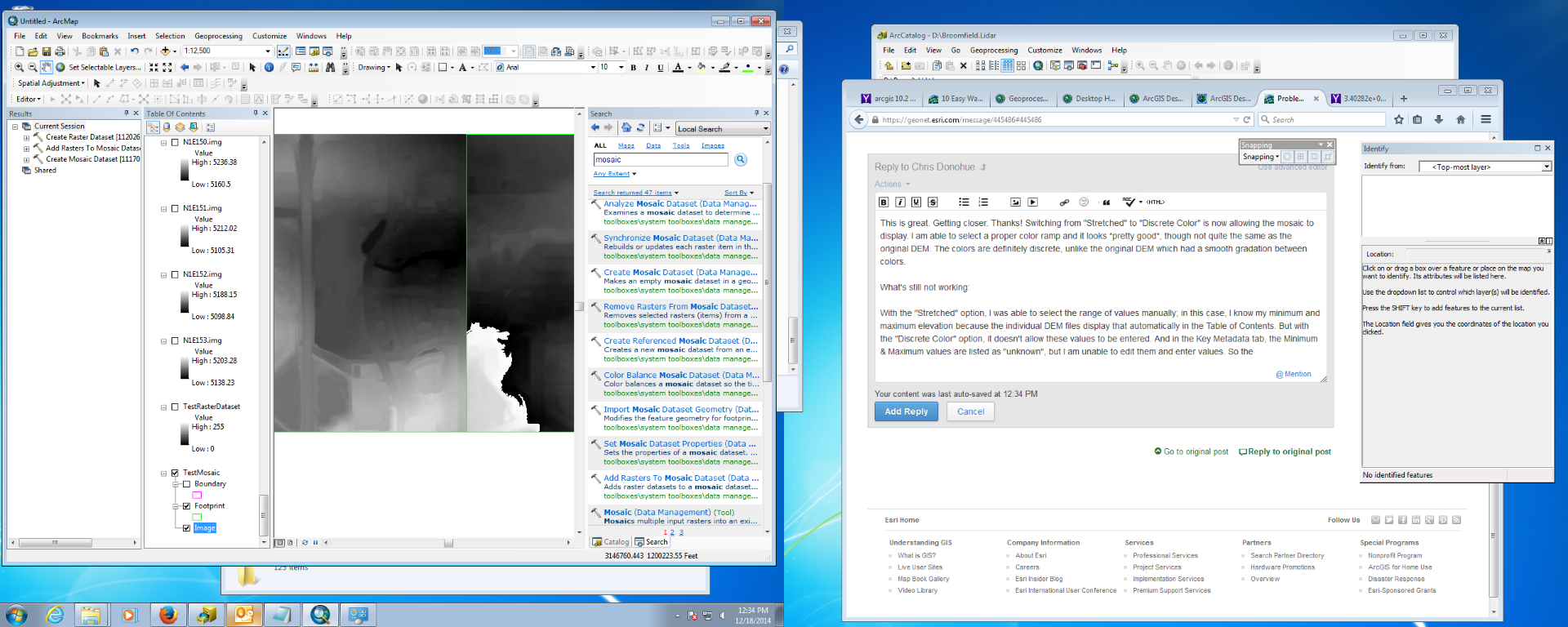
This is great. Getting closer. Thanks! Switching from "Stretched" to "Discrete Color" is now allowing the mosaic to display. I am able to select a proper color ramp and it looks *pretty good*, though not quite the same as the original DEM. The colors are definitely discrete, unlike the original DEM which had a smooth gradation between colors.
What's still not working:
With the "Stretched" option, I was able to select the range of values manually; in this case, I know my minimum and maximum elevation because the individual DEM files display that automatically in the Table of Contents. But with the "Discrete Color" option, it doesn't allow these values to be entered. And in the Key Metadata tab, the Minimum & Maximum values are listed as "unknown", but I am unable to edit them and enter values. So the lights are very light and the darks are very dark in the mosaic, but in the original DEM they are more in between.
Below is a screenshot of the two images. On the left (of the ArcMap window) is the original DEM. On the right (of the ArcMap window) is the mosaic with "Discrete Color" and a white-black color ramp.

Some more information that may clarify the issue:
Using "Stretched", the default minimum & maximum values are way off from what they should be (i.e. the minimum is a negative number, the maximum is a number with an E exponent) and when I set them manually to the proper values, the grey displays.
Thanks,
- Mark as New
- Bookmark
- Subscribe
- Mute
- Subscribe to RSS Feed
- Permalink
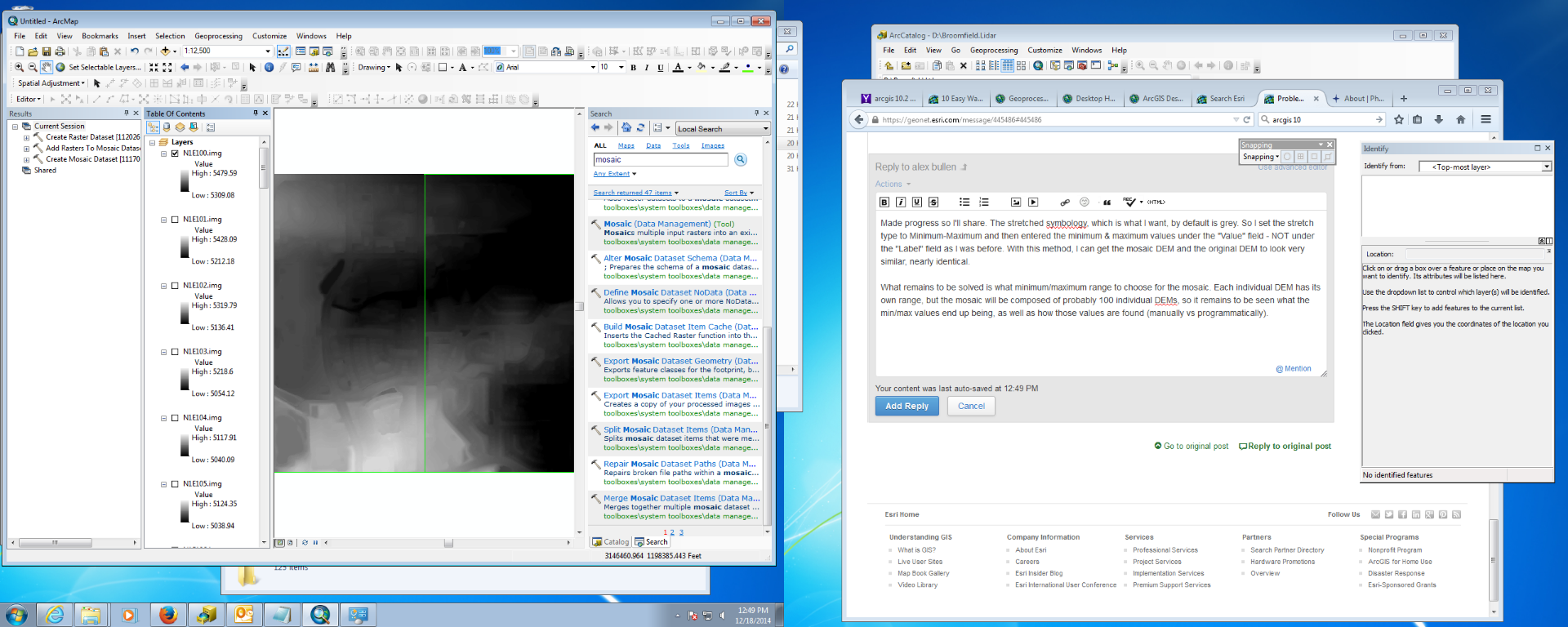
Made progress so I'll share. The stretched symbology, which is what I want, by default is grey. So I set the stretch type to Minimum-Maximum and then entered the minimum & maximum values under the "Value" field - NOT under the "Label" field as I was before. With this method, I can get the mosaic DEM and the original DEM to look very similar, nearly identical.
What remains to be solved is what minimum/maximum range to choose for the mosaic. Each individual DEM has its own range, but the mosaic will be composed of probably 100 individual DEMs, so it remains to be seen what the min/max values end up being, as well as how those values are found (manually vs programmatically).
Here is another screenshot of the DEMs; the left-hand image is the original DEM, the right-hand image is part of the mosaic after following the aforementioned processes.
