- Home
- :
- All Communities
- :
- Products
- :
- Mapping
- :
- Mapping Questions
- :
- Pasted feature is slightly offset
- Subscribe to RSS Feed
- Mark Topic as New
- Mark Topic as Read
- Float this Topic for Current User
- Bookmark
- Subscribe
- Mute
- Printer Friendly Page
- Mark as New
- Bookmark
- Subscribe
- Mute
- Subscribe to RSS Feed
- Permalink
- Report Inappropriate Content
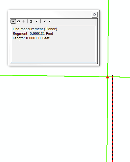
The green lines are quarter section lines. I copied the southern line and pasted it into another polyline layer (the red and black line) but it pastes just slightly offset. This is not the first time I have run into this and it is not keeping from doing the work I need to do, but it bothers me. Anyone happen to know what is going on here?
Solved! Go to Solution.
Accepted Solutions
- Mark as New
- Bookmark
- Subscribe
- Mute
- Subscribe to RSS Feed
- Permalink
- Report Inappropriate Content
It is very very tiny distance. i think it doesn't cause a measure error for you.
If the two layers have the same spatial reference, I think this distance because of variation of tolerance between the two layers.
- Mark as New
- Bookmark
- Subscribe
- Mute
- Subscribe to RSS Feed
- Permalink
- Report Inappropriate Content
True, it doesn't make a real difference in the work I am doing, I am simply curious as to why it happens. Both layers are using the same CRS, what do you mean by "variation of tolerance"?
Thank you!
- Mark as New
- Bookmark
- Subscribe
- Mute
- Subscribe to RSS Feed
- Permalink
- Report Inappropriate Content
I think Abdullah Anter has correctly identified what is going on. If I can elaborate, what you are seeing is due to the extremely zoomed-in view causing visual "misrepresentation" of linework that is actually coincident. The coordinate system used was not mentioned, but at this level of zoom, the measurement is probably well below the unit of accuracy used in that coordinate system. So while visually it looks like it is off, it is actually coincident.
Check out the Resolution and Tolerance sections in this link:
The properties of a spatial reference—ArcGIS Help | ArcGIS Desktop
To double-check, check your measurement against the Resolution and Tolerance settings for the dataset. This can be done using ArcCatalog.
For example, here's a feature class I have in a File Geodatabase. If, for example, the image you show was from this feature class, I would say it is coincident and not an issue, as the measurement of 0.000131 feet is below the XY Resolution and Tolerance settings.

For further reference, here's a related issue thread I posted a while back, including ESRI Support's explanation for the visual wierdness experienced when zoomed way in:
Strangeness - gaps unintentionally created while editing
So brings up another way to realize that what is being seen is probably not realistic. In ArcGIS, check the map scale. If it is below 1:1, what you are seeing may not be an accurate depiction of the true nature of the data (i.e. it can look ugly but be fine).
Chris Donohue, GISP
- Mark as New
- Bookmark
- Subscribe
- Mute
- Subscribe to RSS Feed
- Permalink
- Report Inappropriate Content
I think this is exactly the issue. The resolutions of my line features are indeed greater than the measured "difference" between the two. Definitely an interesting issue and one I will have to keep in mind when ArcMAP tries to lie to me again 
Thanks everyone.