- Home
- :
- All Communities
- :
- Products
- :
- Mapping
- :
- Mapping Questions
- :
- Need to find similar imagery to BLM 100K
- Subscribe to RSS Feed
- Mark Topic as New
- Mark Topic as Read
- Float this Topic for Current User
- Bookmark
- Subscribe
- Mute
- Printer Friendly Page
Need to find similar imagery to BLM 100K
- Mark as New
- Bookmark
- Subscribe
- Mute
- Subscribe to RSS Feed
- Permalink
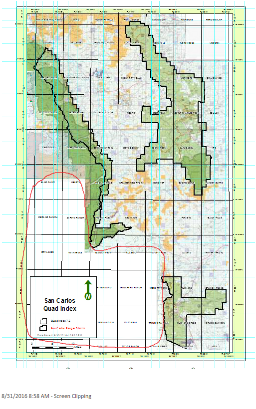
I am working on setting up Quad Index of one Forest Service District on 11 x 17 and I have loaded up 3 of the Visitor Maps on my layout. The problem is the southwest part of the map is blank and I need to find something similar to it. I was thinking of getting one from BLM that might have similar to us. The Forest Service do not have it for that part of the circle I drew. I think BLM might have them similar to us.
Is there a website that can I get it to download . It does not have to be with collar or No colloar. I just need it to load it and put under them with others. I don't want any from the basemap that you add from ArcGIS online.
Location : South of Pubelo, Colorado and north of New Mexico . According to BLM Colorado online, the area I need the most is the
Blanca Peak, Walsenberg, Alomsa and Trinidad. These are the BLM 100k. They have on the PDF but I do not want to spend my time on georeference it and I'd like them to be the most recently current basemap they have. I am willing to download them .

Anybody know where to find it ?

Thank you !
- Mark as New
- Bookmark
- Subscribe
- Mute
- Subscribe to RSS Feed
- Permalink
Hi Robert. I'm not sure how helpful this is, but here is the Colorado BLM GIS data download page. I don't believe there is a published national BLM cached basemap yet.
- Mark as New
- Bookmark
- Subscribe
- Mute
- Subscribe to RSS Feed
- Permalink
They don't need to be basemap just any file that has georeferenced it
- Mark as New
- Bookmark
- Subscribe
- Mute
- Subscribe to RSS Feed
- Permalink
That should work for you, then. They've got TSR, land ownership, and field office areas.