- Home
- :
- All Communities
- :
- Products
- :
- Mapping
- :
- Mapping Questions
- :
- lat and long
- Subscribe to RSS Feed
- Mark Topic as New
- Mark Topic as Read
- Float this Topic for Current User
- Bookmark
- Subscribe
- Mute
- Printer Friendly Page
- Mark as New
- Bookmark
- Subscribe
- Mute
- Subscribe to RSS Feed
- Permalink
Hi all,
I reckon I have lots of gaps about carthography but normally I do not struggle too much in converting coordinates.
I have to plot some coordinates in ARCGIS.
They are in the format below:
43°31.4, 1°46.4
First of all if I tried to add a point (using Go to XY tool) into GIS just to see where these coordinates are it show them in the wrong place.
Normally when I want to convert coordinates in easting and northing to be able to plot them in GIS I do:
(min/60)+degree
If I do the above conversion it gives me the metres and if I plot them in GIS they are shown exactly where the other "Go to XY" shows me.
That is why I believe my conversion is ok.
What should the problem be?
I am really confused and I do not know any other trick to make the job
Many thanks
F
Solved! Go to Solution.
Accepted Solutions
- Mark as New
- Bookmark
- Subscribe
- Mute
- Subscribe to RSS Feed
- Permalink
perhaps convert-coordinate-notation it exists for arcmap and PRO but it only works on data in a table
- Mark as New
- Bookmark
- Subscribe
- Mute
- Subscribe to RSS Feed
- Permalink
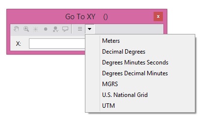
Did you specify the format as Degrees Decimal Minutes in the Go to XY tool?
- Mark as New
- Bookmark
- Subscribe
- Mute
- Subscribe to RSS Feed
- Permalink
Yes I have.
I find strange that either the Go To XY tool and my conversion are working the same and taking me to the wrong place...
- Mark as New
- Bookmark
- Subscribe
- Mute
- Subscribe to RSS Feed
- Permalink
Where did the coordinates come from? If you choose the Identity tool and click on where the point is supposed to be what is the location given? Do you have a the correct spatial reference defined for your map?
- Mark as New
- Bookmark
- Subscribe
- Mute
- Subscribe to RSS Feed
- Permalink
Why do you want to convert your coordinate to use Go To XY tool, if you can change the unit in the tool itself?
- Mark as New
- Bookmark
- Subscribe
- Mute
- Subscribe to RSS Feed
- Permalink
How far off are they? If you identify/click where the point should be, what are the coordinates?
They're still in degree, by the way, not meters.
- Mark as New
- Bookmark
- Subscribe
- Mute
- Subscribe to RSS Feed
- Permalink
Ensure the coordinate system of the Data frame is a Geographic Coordinate System (like GCS_WGS_1984).
Also ensure the notation is correct.
Longitude/X: East is + while West is -
Latitude/Y: North is + while South is -
Think Location
- Mark as New
- Bookmark
- Subscribe
- Mute
- Subscribe to RSS Feed
- Permalink
Thank you everyone.
As I said I have lots of gaps in carthography so because I was desperate yesterday before your comments came in I tried to put a " - " up front the coordinates 1°46.4.And it did work!
I was able to do the job as my coordinates where just 8 vertices of a polygon but my question is: If I have many coordinates like the above (with a N and W), how can I convert them in metres all together?( rather than identifying one by one with the Go To XY tool)
Many thanks for all your useful suggestions and tips.
Cheers,
F
- Mark as New
- Bookmark
- Subscribe
- Mute
- Subscribe to RSS Feed
- Permalink
perhaps convert-coordinate-notation it exists for arcmap and PRO but it only works on data in a table
- Mark as New
- Bookmark
- Subscribe
- Mute
- Subscribe to RSS Feed
- Permalink
You could use Convert Coordinate Notation with appropriate Coordinate Format.
Once you get the point feature class, you could reproject it into a projected coordinate system (UTM, Web-Mercator, etc.) whose units are in Meters.
Think Location