- Home
- :
- All Communities
- :
- Products
- :
- Mapping
- :
- Mapping Questions
- :
- Is there anyway to export a map in layout view as ...
- Subscribe to RSS Feed
- Mark Topic as New
- Mark Topic as Read
- Float this Topic for Current User
- Bookmark
- Subscribe
- Mute
- Printer Friendly Page
Is there anyway to export a map in layout view as tiff file and write geotiff tags
- Mark as New
- Bookmark
- Subscribe
- Mute
- Subscribe to RSS Feed
- Permalink
Hi
When you export a map in data view you can write geotiff and export your map with coordinate. Is there any way to export a map in layout view and write geotiff tags in same time? Or is the only way to get that map with cooordinates to georeference after exporting it ?
Thanks
Solved! Go to Solution.
Accepted Solutions
- Mark as New
- Bookmark
- Subscribe
- Mute
- Subscribe to RSS Feed
- Permalink
Hi Naime,
Although there is no direct way to do it, there is a workaround.
1) Export the Map (in layout view) to GeoPDF (PDF with Map Georeference Information) in ArcMap.
2) Download GDAL. Follow this formula.
Hope it helps!!!
Thanks,
Jay
Think Location
- Mark as New
- Bookmark
- Subscribe
- Mute
- Subscribe to RSS Feed
- Permalink
There is no way to export out georeferenced maps from layout view.
To quote the ESRI help:
"To add georeferencing information, check Write World File. This option is only available when you export while in data view and creates a world file that contains information that is used in conjunction with the exported raster file to tell software where the image is located in the world. The file will have the same name as the image file and a file extension that is based on the first and last letters of the image's file extension plus the letter w. (For example, if you create a TIFF image named MyMap.tif, the world file is called MyMap.tfw.)"
- Mark as New
- Bookmark
- Subscribe
- Mute
- Subscribe to RSS Feed
- Permalink
Hi Naime,
Although there is no direct way to do it, there is a workaround.
1) Export the Map (in layout view) to GeoPDF (PDF with Map Georeference Information) in ArcMap.
2) Download GDAL. Follow this formula.
Hope it helps!!!
Thanks,
Jay
Think Location
- Mark as New
- Bookmark
- Subscribe
- Mute
- Subscribe to RSS Feed
- Permalink
Thank you so much for suggestion that really worked 
- Mark as New
- Bookmark
- Subscribe
- Mute
- Subscribe to RSS Feed
- Permalink
Hi Naime,
Just an update!!!
Now you have a PDF to TIFF (Conversion) tool from ArcGIS 10.3 for Desktop and later.
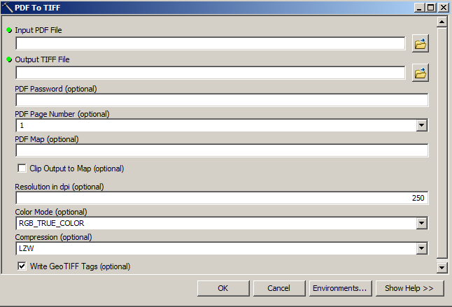
Cheers!!!
Jay
Think Location