- Home
- :
- All Communities
- :
- Products
- :
- Mapping
- :
- Mapping Questions
- :
- In Oklahoma should I use the PLSS or BLM Boundarie...
- Subscribe to RSS Feed
- Mark Topic as New
- Mark Topic as Read
- Float this Topic for Current User
- Bookmark
- Subscribe
- Mute
- Printer Friendly Page
In Oklahoma should I use the PLSS or BLM Boundaries
- Mark as New
- Bookmark
- Subscribe
- Mute
- Subscribe to RSS Feed
- Permalink
I am struggling with:
- Which Land Grid Surveying System to use in in my area, PLSS or BLM.
- The PLSS (Public Land Survey System) or the BLM (Bureau of Land Management) survey systems for the Township / Range & Section Boundaries?
- Which Datum (NAD_27, NAD_83) / GCS (Geographic Coordinate System) and PCS (Projected Coordinate System) should be using to have Accurate Land Grids?
- The problem is my data and the data coming for others sources is not lining up.
- I know this could be from other people using different datum's, but Arc should be able to transform to the correct Datum/Projection within a certain degree of accuracy.
3. I don't know the Most Accurate starting point for the building blocks of my maps, or what data sets I should be using.
- I need to be able to explain what is happening if data isn't lining up.
- Because I don't know the correct data set to use, I can't confidently say my maps are correct.
4. What would be best "data set" to create a "Mapping Standard" to use?
How we are operating now:
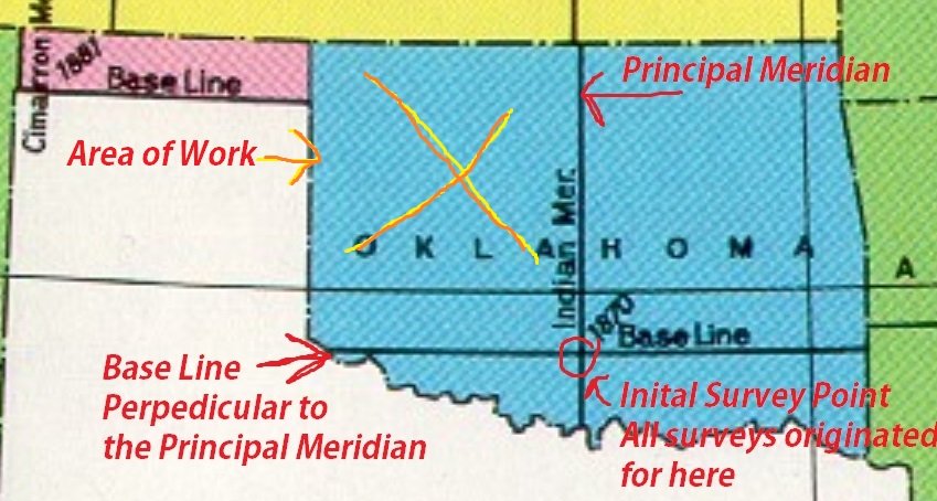
My team is building maps in Oklahoma's North West Corner of the PLSS Base Line, and Principal Meridian.
I am currently using:
| Projected to State Plane_Oklahoma North | GCS Coordinate System NAD_27 |
|---|---|
NAD_1927_StatePlane_Oklahoma_North_FIPS_3501 WKID: 32024 Authority: EPSG False_Easting: 2000000.0 False_Northing: 0.0 Central_Meridian: -98.0 Standard_Parallel_1: 35.56666666666667 Standard_Parallel_2: 36.76666666666667 Latitude_Of_Origin: 35.0 Linear Unit: Foot_US (0.3048006096012192) | Geographic Coordinate System: GCS_North_American_1927 Angular Unit: Degree (0.0174532925199433) Prime Meridian: Greenwich (0.0) Datum: D_North_American_1927 Spheroid: Clarke_1866 Semimajor Axis: 6378206.4 Semiminor Axis: 6356583.799998981 Inverse Flattening: 294.9786982 |
My reasons for using these current parameters:
- I know that NAD_27 originated in Kansas.
Logically this make me think NAD_27's most accurate point would be closest to Kansas. I assume this would be the least distorted GCS to use over than NAD_83 or WGS_84 (possibly).
Here is the description of the BLM and PLSS, from the data itself:
From the https://OKmaps.org website - BLM Sections.
| Title | BLM Sections |
| Date | 2006-05-03 |
| Abstract | THIS DATASET IS NOT COMPLETE FOR OKLAHOMA. This layer is based on Geographic Coordinate Data Base (GCDB) coordinate data. The locations of Public Land Survey System (PLSS) corners, as represented in geographic coordinate pairs, were derived from a variety of source documents, which include U.S. General Land Office and BLM survey plats/notes, as well as survey data obtained from other U.S. Government agencies, private sector survey firms, and local governments. The attributes assigned to PLSS polygons were taken from the BLM's Legal Land Description (LLD) data set, contained within the Legacy Rehost for the year 2000 (LR2000) automated records system. The coordinate data was produced by using control stations of known location, with varying degrees of accuracy, from various sources which include but are not limited to; U.S. Geological Survey (USGS) topological quadrangles and other sources, National Geodetic Survey (NGS) and US Coast & Geodetic Survey (USC&GS) Cooperative Base Network (CBN) control, Federal Base Network control (FBN), and Continuous Operating Reference Stations (CORS), and Global Positioning System (GPS) data, which is then analyzed and adjusted in concert with official survey data for any given geographic area. The Land Survey Information System Data Base (LSIS) data is a useful representation of the geometry and topology of parcels contained within the PLSS, but its application is intended for mapping purposes only. The GCDB data served from LSIS is not a substitute for a legal land survey. |
| Purpose | The GCDB Data was created to provide the BLM and its public with a set of geographic foundation data that accurately portrays the locations of PLSS corners. The GCDB data is based on the best and most current survey records available and uses known geographic positions of control stations within the PLSS network. This data is a key component of the Land Survey Information System (LSIS) framework upon which parcel boundary information will be assembled. |
| Status | onGoing |
| Descriptive Keywords | Cadastral, PLSS, Land Grids, Township, LSI, Range, BLM, National Spatial Data Infrastructure, General Land Office, GLO, NSDI, PLSS, LSIS, Cadastral, Land Survey Information, LIS, Bureau of Land Management, Land Information System, Geographic Coordinate Data Base, GCDB, Sections, Oklahoma, Legal Description, Land Survey Information System, Public Land Survey System, PLSS, Arizona, Nebraska, Nevada, Utah, Oregon, Wyoming, Michigan, Montana, New Mexico, Arkansas, California, Idaho, North Dakota, Colorado, Washington, Contiguous US, Downloadable Data |
| BLM - Data Quality | ||||||||||||
|
PLSS Sections - Data Set
| Title | Sections |
| Date | 2002-06-10 |
| Abstract | This is a copy of the of a data set that contained township, range, and section boundaries from the public land survey system for Oklahoma. This data set was created by appending and editing U.S. Geological Survey Digital Line Graph data sets (1994) based on 1:100,000-scale topographic quadrangles. |
| Purpose | To allow searching by section-township-range and to allow labeling of sections |
| Status | completed |
| Descriptive Keywords | SECT_NUM: the section number by itself, NORTH_SOUT: the direction north or south from the base point, Base Point: one of two points of origin for the rectangular surveys (as stipulated by the Northwest Ordinance of 1785) of Oklahoma the base point for the panhandle is in the southwest corner of Cimarron County, the base point for the rest of the state is in the south central part of the state, EAST_WEST: the direction east or west from the base point, SECTIONS: the section-township-range, MERIDIAN: CM refers to the Cimarron Meridian for the panhandle, IM refers to the Indian Meridian for the rest of the state, sections, TOWNSHIP: the township number north or south of the base point, RANGE: the range range number east or west of the base point, Land Grids, TRS, TR, PLSS, PLS, GLO |
| PLSS - Data Quality | ||||||||||||||
|
Summary:
If you were north of the Indian Baseline and west of the Indian Meridian in Oklahoma. What would you use as your Datum, GCS, and PCS? Then would you use PLSS or BLM Land Grid System?
Thank you if you read all of these, I know it was a lot, LOL.
I appreciate any help y'all could give me.