- Home
- :
- All Communities
- :
- Products
- :
- Mapping
- :
- Mapping Questions
- :
- How do I convert grid cell values to a polygon sha...
- Subscribe to RSS Feed
- Mark Topic as New
- Mark Topic as Read
- Float this Topic for Current User
- Bookmark
- Subscribe
- Mute
- Printer Friendly Page
How do I convert grid cell values to a polygon shapefile?
- Mark as New
- Bookmark
- Subscribe
- Mute
- Subscribe to RSS Feed
- Permalink
I have emission data that provides values on a 1 kilometer resolution that is not in a shapefile format to input in ArcMap and view spatially. If I have a csv file that contains the lambert coordinates of each corner of a grid cell with the respective grid cell value how can I convert this to a polygon/area shapefile? Do my lambert coordinates need to be converted to lat/long or can lambert be read by Arcmap?
- Mark as New
- Bookmark
- Subscribe
- Mute
- Subscribe to RSS Feed
- Permalink
Add Larer-->Ritght key click-->Display X,Y data-->Select X,Y, Z field, Edit Coordinate System-->Right click on the points layer-->Export Data to shape file. A elevation points featrueClass constructed. It can be conversed to polygon if you want.
Lambert coordinate systems are ready for Arcmap, It's best to keep projection coordinate system rather than lat/long format if you want to do further spatial analysis, say Slope.
- Mark as New
- Bookmark
- Subscribe
- Mute
- Subscribe to RSS Feed
- Permalink
Are you sure that the recorded data is for every corner and not the center of the cell? In any event, since you have the data extent within the file and the 'cell size' you could construct Create Fishnet—Help | ArcGIS Desktop and join the point data to it using a spatial join. If you have a few rows of the source file to post here, this might confirm its structure
- Mark as New
- Bookmark
- Subscribe
- Mute
- Subscribe to RSS Feed
- Permalink
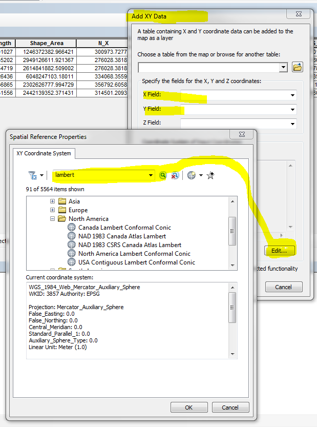
If your coordinates are still in the csv file, you will want to read them in as a table
Table To Table—Help | ArcGIS Desktop
and create a feature class (can be in a file geodatabase and not necessarily a shapefile).
Adding x,y coordinate data as a layer—Help | ArcGIS Desktop (as mentioned by Wu)
There are many Lambert versions available, so you will have to see if the one you need is supported. When you are creating the XY layer, you will need to set the coordinate system for the input data, and you can search for "Lambert" to see you options.
Then I would follow Dan's advise on either creating a fishnet, or if these are centerpoints and not lower-left (or other corners), there might be other ways to show the 1km resolution.