- Home
- :
- All Communities
- :
- Products
- :
- Mapping
- :
- Mapping Questions
- :
- How do I change a map to squares
- Subscribe to RSS Feed
- Mark Topic as New
- Mark Topic as Read
- Float this Topic for Current User
- Bookmark
- Subscribe
- Mute
- Printer Friendly Page
- Mark as New
- Bookmark
- Subscribe
- Mute
- Subscribe to RSS Feed
- Permalink
I would like to know how can I change my map to squares with an specific size (62,500 ft2 – 360,000 ft2).
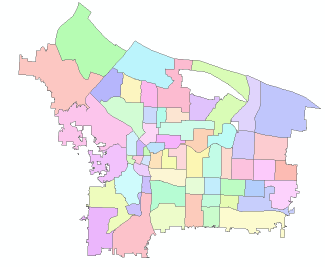
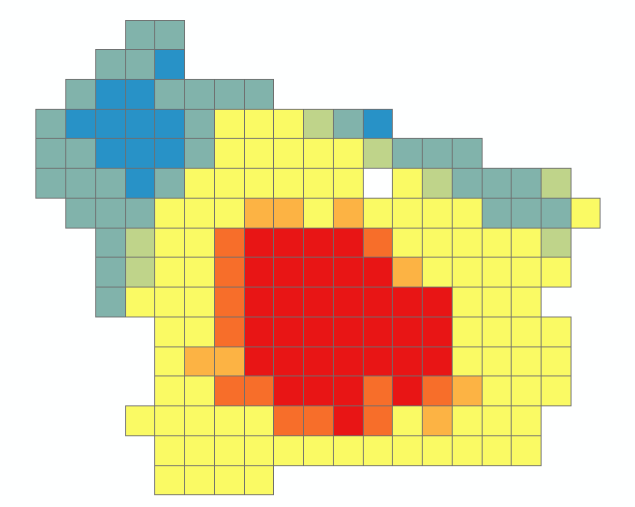
To something like this, but with smaller squares:
Solved! Go to Solution.
Accepted Solutions
- Mark as New
- Bookmark
- Subscribe
- Mute
- Subscribe to RSS Feed
- Permalink
There are several ways to do this. Here's some methods. Note also the Important Considerations below.
1). If you have access to the Spatial Analyst Extension, you could convert your polyyons to raster using the Feature To Raster Geoprocesing tool (or one of the several vector to conversion tools), specifying the size of the square. Then convert that raster back to vector.
Here's the help for ArcGIS Pro, which will give you a general idea of how it works. Look up the specifics in the help for your version and software, as there may be differences:
Feature to Raster—Conversion toolbox | ArcGIS for Desktop
Raster to Polygon—Conversion toolbox | ArcGIS for Desktop
2). You could create a Fishnet for your project extent. Then use a Spatial Join to attach the attributes to the fishnet. Last, delete the polygons on the exterior that did not cover the input data. The Spatial Join could be performed with either the Geoprocessing tool of the same name or by doing a Join to the Attribute Table of the Fishnet based on Location.
Create Fishnet—Help | ArcGIS for Desktop
Spatial Join—Help | ArcGIS for Desktop
Important Considerations:
Before running any process, you will need to decide what the desired result will be when one of the "squares" covers multiple polygons in your input data. In other words, what value would you expect to end up assigned to the "square" in your new fishnet or raster? The above methods will produce different results, so this will need to be considered.
Some possibilities (there are several):
- Average of all values covered by the new "square"
- Only the value at the exact center of the "square"
To resolve this:
- Some methods offer options to change how the desired value is determined, so look at the Help for each method.
- An intermediate feature class may need to be created to use in the processing. For example, if the desired output is the value at the exact center of the new "square", you may want to create a Centroids point layer of the exact center of each of the new squares and then Join your original data to that point layer, then Join the point layer to the new squares (polygons).
http://help.arcgis.com/EN/ArcGISDesktop/10.0/Help/index.html#//00170000003m000000
Chris Donohue, GISP
- Mark as New
- Bookmark
- Subscribe
- Mute
- Subscribe to RSS Feed
- Permalink
you could rasterize it to produce a grid.
I don't thin a fishnet with a spatial join would work, but you could give that a shot.
A cartogram is often used to distort space to represent quantities, but I don't know of any that produce squares.
That's all for now
- Mark as New
- Bookmark
- Subscribe
- Mute
- Subscribe to RSS Feed
- Permalink
There are several ways to do this. Here's some methods. Note also the Important Considerations below.
1). If you have access to the Spatial Analyst Extension, you could convert your polyyons to raster using the Feature To Raster Geoprocesing tool (or one of the several vector to conversion tools), specifying the size of the square. Then convert that raster back to vector.
Here's the help for ArcGIS Pro, which will give you a general idea of how it works. Look up the specifics in the help for your version and software, as there may be differences:
Feature to Raster—Conversion toolbox | ArcGIS for Desktop
Raster to Polygon—Conversion toolbox | ArcGIS for Desktop
2). You could create a Fishnet for your project extent. Then use a Spatial Join to attach the attributes to the fishnet. Last, delete the polygons on the exterior that did not cover the input data. The Spatial Join could be performed with either the Geoprocessing tool of the same name or by doing a Join to the Attribute Table of the Fishnet based on Location.
Create Fishnet—Help | ArcGIS for Desktop
Spatial Join—Help | ArcGIS for Desktop
Important Considerations:
Before running any process, you will need to decide what the desired result will be when one of the "squares" covers multiple polygons in your input data. In other words, what value would you expect to end up assigned to the "square" in your new fishnet or raster? The above methods will produce different results, so this will need to be considered.
Some possibilities (there are several):
- Average of all values covered by the new "square"
- Only the value at the exact center of the "square"
To resolve this:
- Some methods offer options to change how the desired value is determined, so look at the Help for each method.
- An intermediate feature class may need to be created to use in the processing. For example, if the desired output is the value at the exact center of the new "square", you may want to create a Centroids point layer of the exact center of each of the new squares and then Join your original data to that point layer, then Join the point layer to the new squares (polygons).
http://help.arcgis.com/EN/ArcGISDesktop/10.0/Help/index.html#//00170000003m000000
Chris Donohue, GISP
- Mark as New
- Bookmark
- Subscribe
- Mute
- Subscribe to RSS Feed
- Permalink
I made a video doing it:
Fishnet - Arcgis ArcMap 10.4 - YouTube