- Home
- :
- All Communities
- :
- Products
- :
- Mapping
- :
- Mapping Questions
- :
- Re: Generate several maps automatically
- Subscribe to RSS Feed
- Mark Topic as New
- Mark Topic as Read
- Float this Topic for Current User
- Bookmark
- Subscribe
- Mute
- Printer Friendly Page
- Mark as New
- Bookmark
- Subscribe
- Mute
- Subscribe to RSS Feed
- Permalink
Hello
Anyone knows how to automatically generate over 600 Maps (Size A7) in ArcGIS? I heard of Mapbook Generator but I dont really understand how to apply it.
I use ArcGIS 10.2
Thanks!
Solved! Go to Solution.
Accepted Solutions
- Mark as New
- Bookmark
- Subscribe
- Mute
- Subscribe to RSS Feed
- Permalink
Hey P V,
I don't know if this will help or not, but ESRI has a free class that takes you through the steps of creating data driven pages amongst other things. It takes about 3 hours, but it might be helpful. You can find it here Esri Training | Using ArcMap in ArcGIS Desktop 10
- Mark as New
- Bookmark
- Subscribe
- Mute
- Subscribe to RSS Feed
- Permalink
In addition to what FC Basson indicates, you may find the next two links helpful:
They visually explain what you can obtain by using data driven pages.
- Mark as New
- Bookmark
- Subscribe
- Mute
- Subscribe to RSS Feed
- Permalink
Thank you FC Basson and Xander Bakker
I read the Information but I could not figure on how to create these maps when I have one Shapefile with several different species in it. Is there a way to show each species seperately with the same map extend map with several other layers together like forest or water bodies?
Also I could not set the size to A7.
- Mark as New
- Bookmark
- Subscribe
- Mute
- Subscribe to RSS Feed
- Permalink
Hey P V,
I don't know if this will help or not, but ESRI has a free class that takes you through the steps of creating data driven pages amongst other things. It takes about 3 hours, but it might be helpful. You can find it here Esri Training | Using ArcMap in ArcGIS Desktop 10
- Mark as New
- Bookmark
- Subscribe
- Mute
- Subscribe to RSS Feed
- Permalink
Personally, I would throw in some Python code to do this, but I guess you could do this with DDPs.
You could dissolve your species to create a single multipart feature per specie.
To define the page size, you should in Layout mode, right click on the border outside your dataframe but still on the page and select Page and Print Setup: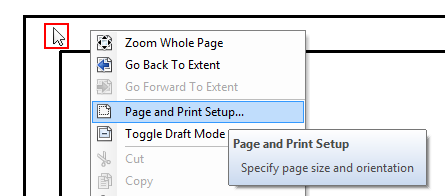
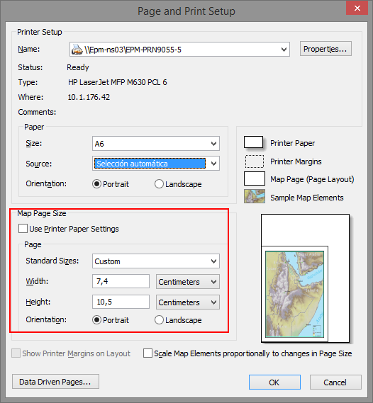
Then, define the custom paper size in case your printer driver does not have A7:
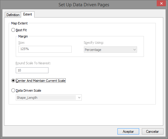
To maintain the same extent, setup the DDP like this.
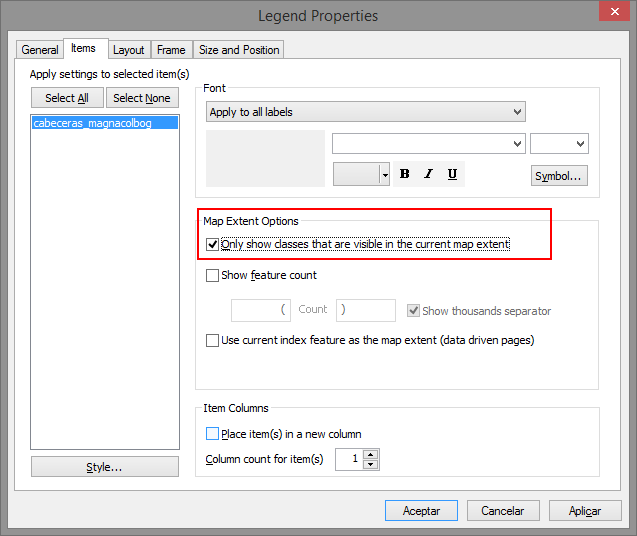
... and since you will only show 1 species per page, you may want to make the legend dynamic:
- Mark as New
- Bookmark
- Subscribe
- Mute
- Subscribe to RSS Feed
- Permalink
Thanks, I managed to get the desired layout. However, when I generate the 600 maps, all the maps are just somewhere random within the data frame. Is there a way to have all the maps at the same position, like in the center of the map page?
- Mark as New
- Bookmark
- Subscribe
- Mute
- Subscribe to RSS Feed
- Permalink
What if you double click on the Dataframe name (probably "Layers") in the TOC, select the tab "Data frame", set the Extent to "Fixed Extent", Specify Extent and take for instance the current visible extent?
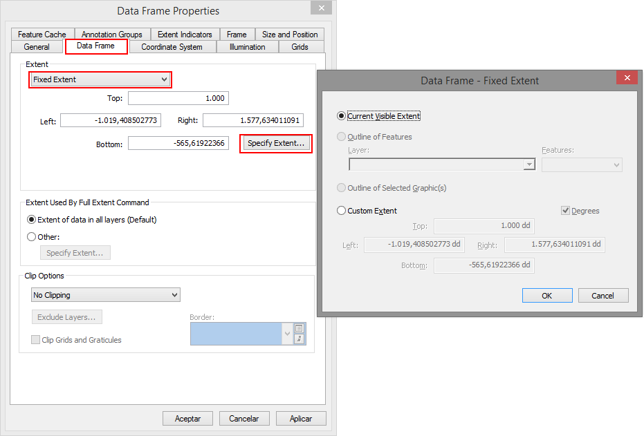
Does that work?
- Mark as New
- Bookmark
- Subscribe
- Mute
- Subscribe to RSS Feed
- Permalink
Xander Bakker thought of that as well but as I use data driven pages I cannot change the settings for the extend.
I also tried to set the extend to "fixed extend" before creating the DDP, but it still will Switch to Current Data Driven Page and move around within the extend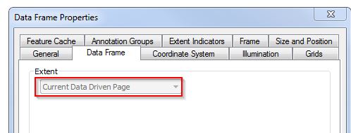
- Mark as New
- Bookmark
- Subscribe
- Mute
- Subscribe to RSS Feed
- Permalink
Another option in Data Drive Pages (DDP) that may help is in controlling what information is displayed is a Page Definition Query. Darren Wiens posted about this yesterday in this GeoNet thread:
Chris Donohue, GISP