- Home
- :
- All Communities
- :
- Products
- :
- Mapping
- :
- Mapping Questions
- :
- Re: Export to .ai . eps
- Subscribe to RSS Feed
- Mark Topic as New
- Mark Topic as Read
- Float this Topic for Current User
- Bookmark
- Subscribe
- Mute
- Printer Friendly Page
- Mark as New
- Bookmark
- Subscribe
- Mute
- Subscribe to RSS Feed
- Permalink
Is there a possibility to export in this format with the availability for editing the layer symbology in a graphic software?
Normal export to .ai doesn't work?
Solved! Go to Solution.
Accepted Solutions
- Mark as New
- Bookmark
- Subscribe
- Mute
- Subscribe to RSS Feed
- Permalink
My initial thought was you had a transparency applied which rasterizes everything below into a single raster element in teh output file but...are you saying the same Ai file opened in your version of Illustrator does not work as expected but does for your graphic designer whe s/he opens it in Illy?
Can you post the problematic file? Or a non sensitive problem file with the same issue?
- Mark as New
- Bookmark
- Subscribe
- Mute
- Subscribe to RSS Feed
- Permalink
I am not having any troubles editing the layer symbology going from ArcMAP 10.2 to Illustrator CS3. I export out using .ai and each layer appears as a sub-layer in Illustrator. At this point I can selet the individual entites and make changes. Which graphic software program are you using?
- Mark as New
- Bookmark
- Subscribe
- Mute
- Subscribe to RSS Feed
- Permalink
Hi William,
if I use .ai in 10.1 I can't do that in illustrator CS 6?
I have tried .eps as well. What setting do u use in export?
- Mark as New
- Bookmark
- Subscribe
- Mute
- Subscribe to RSS Feed
- Permalink
I use .ai to export from ArcMAP 10.2. I have been using this since version 8 with no problems. And my graphic designer is actually using Illustrator CS6 with no problems editing the exported map.
- Mark as New
- Bookmark
- Subscribe
- Mute
- Subscribe to RSS Feed
- Permalink
As mentioned I couldn't do that. What does your graphic designer to get access(ungroup ... ?) (or does he nothing?)and how do you export?
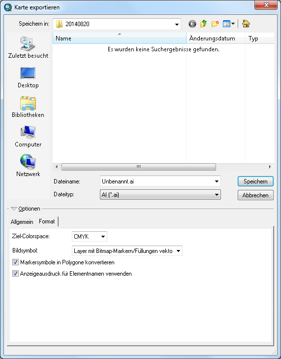
My settings:
- Mark as New
- Bookmark
- Subscribe
- Mute
- Subscribe to RSS Feed
- Permalink
Yes this is what I use. However, I have both of the check marks turned off on this page. I also use a resolution that is divisible by 72. So click on the "Allgemein" button and change your resolution to 360 for "low" resolution or 1224 for "high" resolution. Once the .ai file is created, open Illustrator and each layer in your map should be listed as a sublayer in Illustrator available to edit.
- Mark as New
- Bookmark
- Subscribe
- Mute
- Subscribe to RSS Feed
- Permalink
My initial thought was you had a transparency applied which rasterizes everything below into a single raster element in teh output file but...are you saying the same Ai file opened in your version of Illustrator does not work as expected but does for your graphic designer whe s/he opens it in Illy?
Can you post the problematic file? Or a non sensitive problem file with the same issue?
- Mark as New
- Bookmark
- Subscribe
- Mute
- Subscribe to RSS Feed
- Permalink
Thanks Sam it was the transparency
- Mark as New
- Bookmark
- Subscribe
- Mute
- Subscribe to RSS Feed
- Permalink
Glad you sorted it—so that means your Illustrator guy would have had the same issues.
- Mark as New
- Bookmark
- Subscribe
- Mute
- Subscribe to RSS Feed
- Permalink
Hi William,
i am using Gis 10
When i export ai. pdf. only english font showing.but other text fornt not showing
Hi William,
if I use .ai in 10.1 I can't do that in illustrator CS 6?
I have tried .eps as well. What setting do u use in export?