- Home
- :
- All Communities
- :
- Products
- :
- Mapping
- :
- Mapping Questions
- :
- Do you "reposition the central meridian"? If so, h...
- Subscribe to RSS Feed
- Mark Topic as New
- Mark Topic as Read
- Float this Topic for Current User
- Bookmark
- Subscribe
- Mute
- Printer Friendly Page
Do you "reposition the central meridian"? If so, how?
- Mark as New
- Bookmark
- Subscribe
- Mute
- Subscribe to RSS Feed
- Permalink
Hi all -
I'm teaching an intro-level "GeoTechniques" class this semester. It's my first term teaching. I'm using the reading Making a Meaningful Map among others. The authors refer to a process where you are "repositioning the central meridian... to the center of the mapped area" (p.2). It does make sense to me that this could be done, but having always mapped with State Plane I've never had the need to do it.
Do you do this? If so, how?! This embarks on creating a custom projection, no?
Thanks in advance for any thoughts/comments on this.
Cheers,
Joanna
Solved! Go to Solution.
Accepted Solutions
- Mark as New
- Bookmark
- Subscribe
- Mute
- Subscribe to RSS Feed
- Permalink
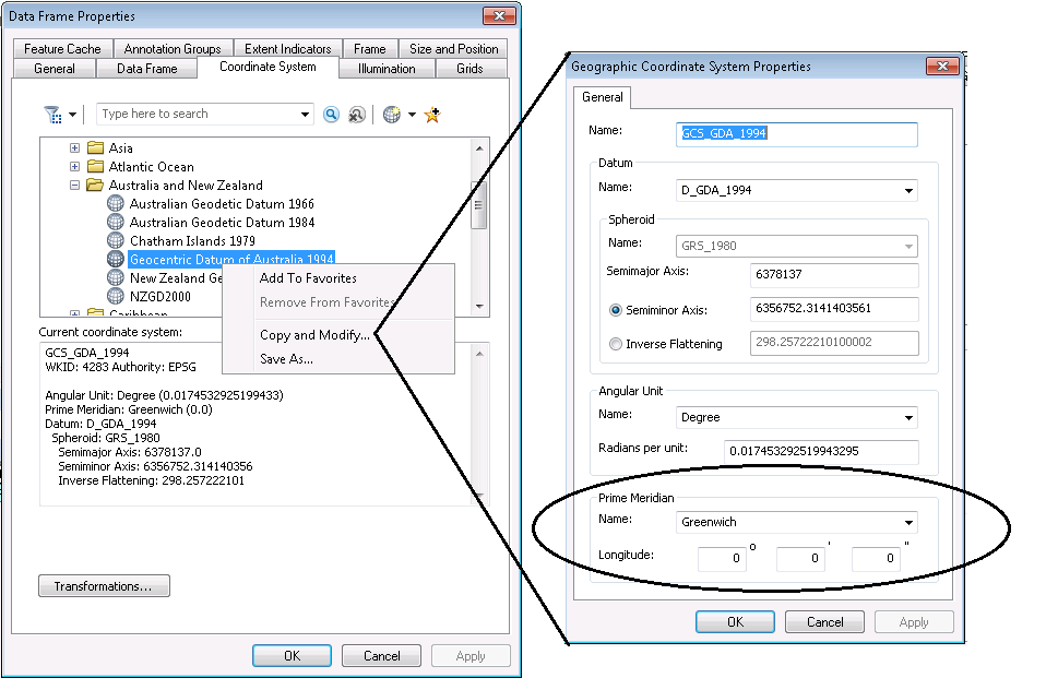
Sorry, Kishor, but no! That's changing the prime meridian aka the longitude origin in a geographic coordinate reference system. There are reasons to do that (like moving the +/-180 line away from the center of the Pacific Ocean), but is not what Joanna is asking about.
Joanna, there's actually two solutions. One is just to use an existing coordinate reference system that is reasonable for the data. That might be the local State Plane zone, or maybe a UTM zone would be better.
Similar to how Kishor right-clicked a geographic CRS and opened its property page, you could do the same thing with a projected CRS and modify the central meridian. You can also create a custom CRS from scratch, but personally, I always modify instead.
- Mark as New
- Bookmark
- Subscribe
- Mute
- Subscribe to RSS Feed
- Permalink
Open coordinate system window > Select the coordinate system you need > Right click and select Copy and modify > Change the parameters and click Ok.
Hope this is helpful

- Mark as New
- Bookmark
- Subscribe
- Mute
- Subscribe to RSS Feed
- Permalink
Sorry, Kishor, but no! That's changing the prime meridian aka the longitude origin in a geographic coordinate reference system. There are reasons to do that (like moving the +/-180 line away from the center of the Pacific Ocean), but is not what Joanna is asking about.
Joanna, there's actually two solutions. One is just to use an existing coordinate reference system that is reasonable for the data. That might be the local State Plane zone, or maybe a UTM zone would be better.
Similar to how Kishor right-clicked a geographic CRS and opened its property page, you could do the same thing with a projected CRS and modify the central meridian. You can also create a custom CRS from scratch, but personally, I always modify instead.
- Mark as New
- Bookmark
- Subscribe
- Mute
- Subscribe to RSS Feed
- Permalink
I'm more confused now. I think that Kishor is actually answering my question. I guess I'm asking, in a more academic sense... a) is this done if the projection is...er... slanted at your particular region of interest? and b) if yes, your region is slanted and you really want to stick with that projection for some reason, then how do you go about doing this? And it sounds like Kishor's answer is right for that. Yes?
Thanks so much! We have a comparative projections exercise later in the term that shows how the US slants extremely in one projection versus looking "normal" in another. I know that students are going to ask something along the lines of "can't you change the projection's central longitude?" they may not be that articulate, but they'll ask and I want to tell them yes/no and how, at least at a basic level.
Thanks!
- Mark as New
- Bookmark
- Subscribe
- Mute
- Subscribe to RSS Feed
- Permalink
Melita accurately describes the process
- Mark as New
- Bookmark
- Subscribe
- Mute
- Subscribe to RSS Feed
- Permalink
Hi Joanna,
Since we display all geographic CRS in a "pseudo-Plate Carree" projection (it's Plate Carree aka equirectangular but the coordinates aren't scaled by the ellipsoid's semimajor radius), changing the prime meridian will affect what's displayed in the center, and thus the left and right longitudes.
For slanted data, that is directly affected by the data location relative to the central meridian or the central point of the projection. Use a California state plane zone for the contiguous US, and the eastern half is going to be distinctly slanted! In that case, it's better to use a projection designed for the contiguous US, with its central meridian near the middle of the country. It will also depend on the type of projection used. If you use a conical projection for the contiguous US, there will still be some tilt because of the size of the country. You would have to switch to a cylindrical projection instead.
It's very easy to try all kinds of scenarios out in ArcMap, because you can change the data frame's coordinate system without messing with the data's coordinate systems at all. Give it a whirl!
- Mark as New
- Bookmark
- Subscribe
- Mute
- Subscribe to RSS Feed
- Permalink
Thanks
- Mark as New
- Bookmark
- Subscribe
- Mute
- Subscribe to RSS Feed
- Permalink
Would be nice if you could show how in the video ? ![]()
- Mark as New
- Bookmark
- Subscribe
- Mute
- Subscribe to RSS Feed
- Permalink
Are you referring to false easting? If measuring in linear distance (meters, feet) this can have the effect of making coordinate values smaller, giving a little more precision and making arithmetic a little easier. Our organization implements a Lambert Conformal Conic projection that subtracts 1,000,000 meters from values for UTM meters.
NAD_1983_Lambert_Conformal_Conic
Authority: Custom
Projection: Lambert_Conformal_Conic
False_Easting: 1000000.0
False_Northing: 1000000.0
Central_Meridian: -100.0
Standard_Parallel_1: 34.91666666666666
Standard_Parallel_2: 27.41666666666667
Latitude_Of_Origin: 31.16666666666667
Linear Unit: Meter (1.0)
Geographic Coordinate System: GCS_North_American_1983
Angular Unit: Degree (0.0174532925199433)
Prime Meridian: Greenwich (0.0)
Datum: D_North_American_1983
Spheroid: GRS_1980
Semimajor Axis: 6378137.0
Semiminor Axis: 6356752.314140356
Inverse Flattening: 298.257222101
This same method is implemented in the state plan coordinate system, for example
NAD_1983_StatePlane_Texas_South_Central_FIPS_4204_Feet
WKID: 2278 Authority: EPSG
Projection: Lambert_Conformal_Conic
False_Easting: 1968500.0
False_Northing: 13123333.33333333
Central_Meridian: -99.0
Standard_Parallel_1: 28.38333333333333
Standard_Parallel_2: 30.28333333333334
Latitude_Of_Origin: 27.83333333333333
Linear Unit: Foot_US (0.3048006096012192)
Geographic Coordinate System: GCS_North_American_1983
Angular Unit: Degree (0.0174532925199433)
Prime Meridian: Greenwich (0.0)
Datum: D_North_American_1983
Spheroid: GRS_1980
Semimajor Axis: 6378137.0
Semiminor Axis: 6356752.314140356
Inverse Flattening: 298.257222101
The two examples given here are useful for Central Texas (the Lambert CC projection given above is in wide use here)--although lately, the WGS Auxiliary Sphere projection is coming into more use as we move towards more work with interactive maps!
- Mark as New
- Bookmark
- Subscribe
- Mute
- Subscribe to RSS Feed
- Permalink
I have done this by creating a custom projection. The area I normally map is near the center of UTM zone 12, but there is a separate project area that I sometimes map, which is near the boundary of zone 11 and 12. The streets in that city are on a grid, and the distortion is very apparent at the edges of the UTM zones, which is a cosmetic issue for my particular audience.
I get around that by creating my own UTM zone for the Data Frame, with the central meridian shifted 3 degrees west from the central meridian of zone 12 (3 degrees east from the central meridian of zone 11). I call it UTM zone 11.5 It fixes the distortion issue, but I would never create data in that coordinate system.
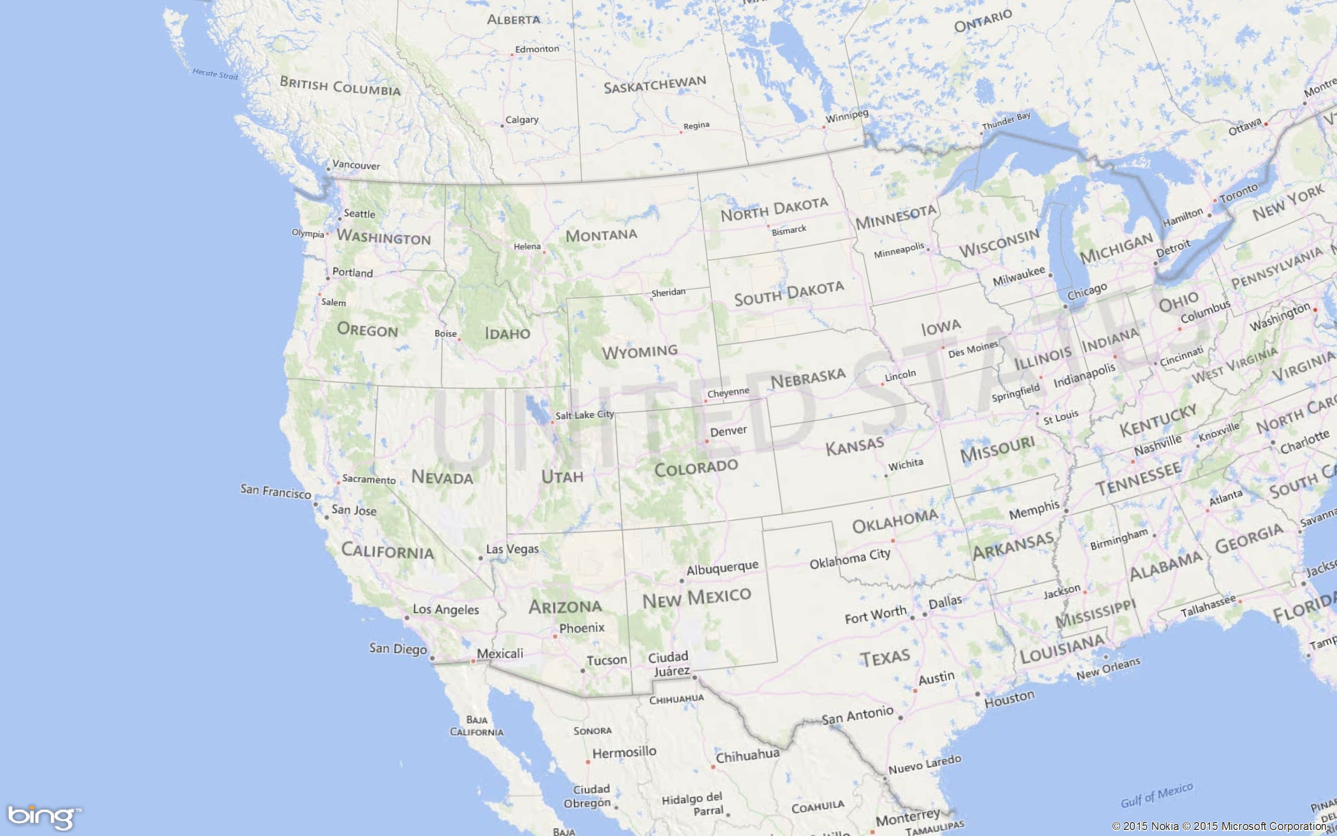
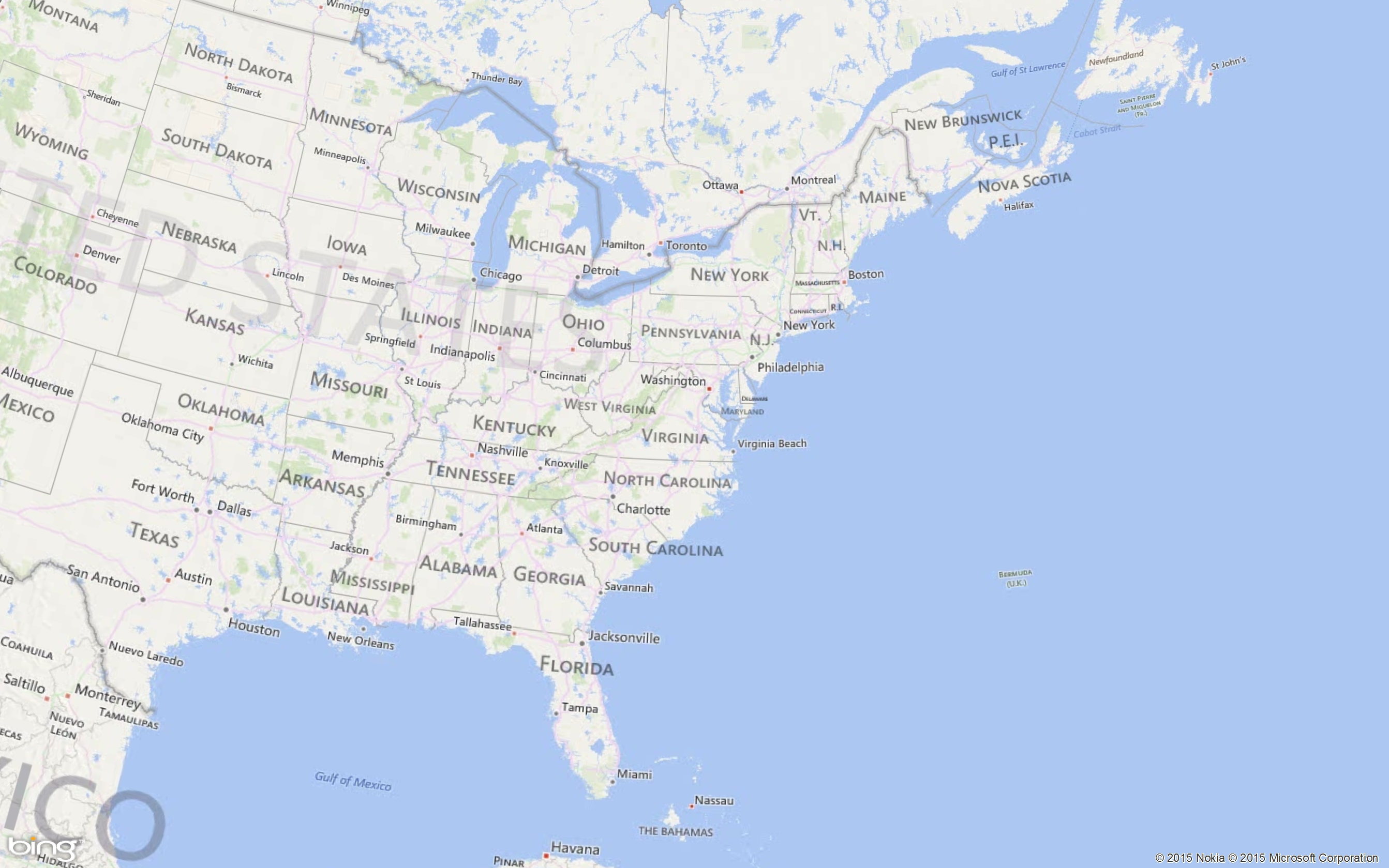
It sounds like you're referring to repositioning the central meridian to reduce the appearance of distortion in a similar way. If you're using a conical projection, the lines of latitude appear to bend upward (in the northern hemisphere) away from the meridian over which the projection is centered. If you move the central meridian, you can reduce the appearance of that distortion in your area of focus.
I attached two examples of a Lambert Conformal Conic projection, one with a central meridian positioned over the west coast, the other over the New England area. All of the other projection parameters, and the map scale, are identical...

