- Home
- :
- All Communities
- :
- Products
- :
- Mapping
- :
- Mapping Questions
- :
- Re: compatibilidade
- Subscribe to RSS Feed
- Mark Topic as New
- Mark Topic as Read
- Float this Topic for Current User
- Bookmark
- Subscribe
- Mute
- Printer Friendly Page
compatibilidade (Data created in QGIS does not align in ArcMap)
- Mark as New
- Bookmark
- Subscribe
- Mute
- Subscribe to RSS Feed
- Permalink
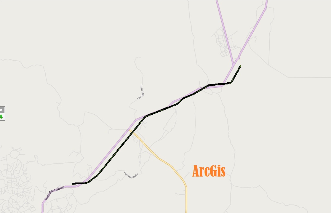
Criei um percurso no QGis usando OpenLayer plugin Google Streets, e agora que tenho que trabalhar no ArcGis não consigo fazer com que os pontos caiam nos lugares certos...
Estou usando ArcBrutile google roads no ArcGis...
Subject was edited by: Timothy Hales
- Mark as New
- Bookmark
- Subscribe
- Mute
- Subscribe to RSS Feed
- Permalink
Google Translation: I created a route in QGIS using OpenLayer Google Streets plugin, and now I have to work in ArcGIS can not make the points fall in the right places ...
I'm using google ArcBrutile roads in ArcGIS ...
What coordinate system did you create the streets layer in QGIS? What coordinate system is your map in ArcGIS?
- Mark as New
- Bookmark
- Subscribe
- Mute
- Subscribe to RSS Feed
- Permalink
I'm using camacupa 33S... is the system we use in Angola, Africa...
- Mark as New
- Bookmark
- Subscribe
- Mute
- Subscribe to RSS Feed
- Permalink
Camacupa 33S is UTM, so there should not be a transformation issue. Could you start a new ArcMap sessions, add your points layer first, and then add the other reference data?
- Mark as New
- Bookmark
- Subscribe
- Mute
- Subscribe to RSS Feed
- Permalink
It will indeed be a transformation issue. The coordinate system of the line (UTM 33S) has nothing to do with the underlying GCS source of the data.
I am surprised that QGis makes such a good fit! But I do suspect that there is something about the original data (how was this line acquired?), and the coordinate system of the ArcMap data frame.
Was the correct transformation selected here?
Camacupa is a tricky one. I researched this many moons ago. All the available transformations between Camacupa & WGS84 have been calculated by the oil industry and are for specific offshore oil concessions. Back then there were no valid transformations for onshore Angola.
I would like to hear from Miguel if this situation has now been rectified.
Google translate version:
Na verdade, será uma questão de transformação. O sistema de coordenadas da linha (UTM 33S) não tem nada a ver com a fonte subjacente GCS dos dados.
Estou surpreso que qgis faz um bom ajuste, tais! Mas eu suspeito que há algo sobre os dados originais (como foi esta linha adquirido?), Eo sistema do quadro de dados do ArcMap coordenadas.
Foi a transformação correta selecionada aqui?
Camacupa é um assunto delicado. Eu pesquisei isso muitas luas atrás. Todas as transformações disponíveis entre Camacupa & WGS84 foram calculados pela indústria do petróleo e são para concessões específicas de petróleo offshore. Naquela época não havia transformações válidos para onshore Angola.
Eu gostaria de ouvir de Miguel se esta situação foi agora corrigida.
- Mark as New
- Bookmark
- Subscribe
- Mute
- Subscribe to RSS Feed
- Permalink
Neilson Ayers Thanks for the added local knowledge. I just made an assumption that all of the data (reference data and collected data) was using Camacupa 33S. I see now how this could be a transformation issue.
- Mark as New
- Bookmark
- Subscribe
- Mute
- Subscribe to RSS Feed
- Permalink
QGIS uses GDAL and PROJ.4 for coordinate systems. Miguel, check the Camacupa UTM 33S definition in QGIS and look for the PROJ.4 string. It will look something like this:
+proj=tm +lon_0=15.0 +lat_0=0.0 ...
See if there is a +towgs84 parameter and post those values here. With those values, we can look up an equivalent transformation for ArcMap, or tell you how to define a custom geographic/datum transformation.
Melita
Google translate:
QGIS usa GDAL e PROJ.4 para sistemas de coordenadas. Miguel, verifique a definição Camacupa UTM 33S no QGIS e procurar a cadeia PROJ.4. Ele será parecido com este:
+ proj = tm + lon_0 = 15,0 + lat_0 = 0.0 ...
Veja se há um parâmetro +towgs84 e postar esses valores aqui. Com esses valores, nós podemos olhar para uma transformação equivalente para ArcMap, ou dizer-lhe como definir uma transformação geográfica / datum personalizado.