Turn on suggestions
Auto-suggest helps you quickly narrow down your search results by suggesting possible matches as you type.
Cancel
- Home
- :
- All Communities
- :
- Products
- :
- Mapping
- :
- Mapping Questions
- :
- changing coordinate systems
Options
- Subscribe to RSS Feed
- Mark Topic as New
- Mark Topic as Read
- Float this Topic for Current User
- Bookmark
- Subscribe
- Mute
- Printer Friendly Page
changing coordinate systems
Subscribe
5317
11
10-09-2014 07:34 AM
10-09-2014
07:34 AM
- Mark as New
- Bookmark
- Subscribe
- Mute
- Subscribe to RSS Feed
- Permalink
Greetings....I have received a mdx file from an outside source. It is in NAD 1983 UTM 15N. I would like to work in it using a state plane coordinate system. Can someone tell me how to change that? Thanks
11 Replies
10-15-2014
07:41 AM
- Mark as New
- Bookmark
- Subscribe
- Mute
- Subscribe to RSS Feed
- Permalink
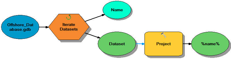
You can make a tool for that:
10-16-2014
12:18 PM
- Mark as New
- Bookmark
- Subscribe
- Mute
- Subscribe to RSS Feed
- Permalink
If you browse to a tool in ArcToolbox, right-click the tool. That will open a batch version of the tool. Basically, it's a mini-spreadsheet so you can enter multiple input datasets, etc.
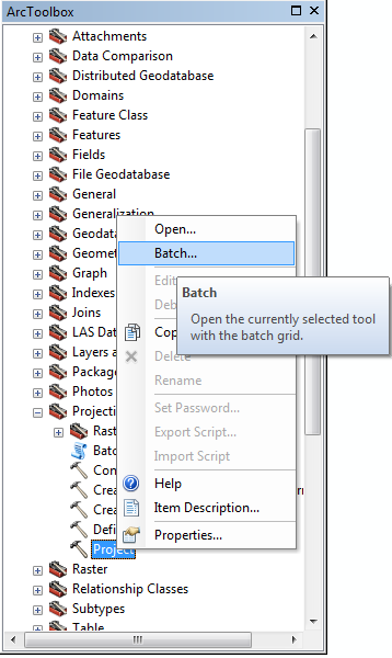
Don't bother using the actual "Batch Project" tool. It's buggy.
Melita
- « Previous
-
- 1
- 2
- Next »
- « Previous
-
- 1
- 2
- Next »