- Home
- :
- All Communities
- :
- Products
- :
- Mapping
- :
- Map Projections Questions
- :
- What is the projection for Russia and Alaska area ...
- Subscribe to RSS Feed
- Mark Topic as New
- Mark Topic as Read
- Float this Topic for Current User
- Bookmark
- Subscribe
- Mute
- Printer Friendly Page
What is the projection for Russia and Alaska area ?
- Mark as New
- Bookmark
- Subscribe
- Mute
- Subscribe to RSS Feed
- Permalink
Hi
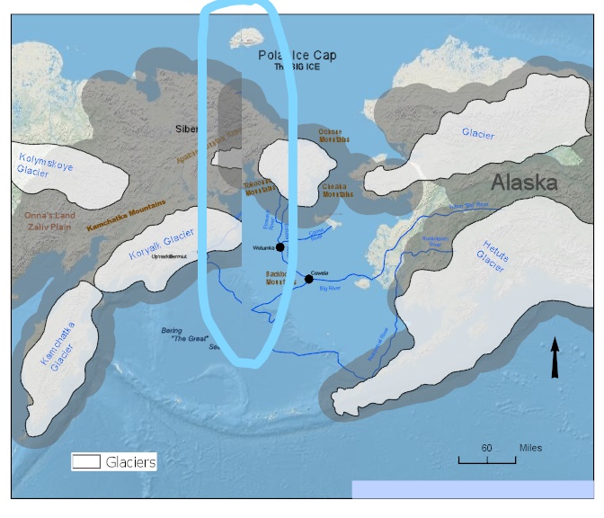
I am working on this map for somebody and I need help to make this line between Far East Russia and Alaska disappear and which projection is the right one to use for this area ?... I am using ArcGIS Pro 2.4 and use the WGS 1984 Web Mercator Auxiliary Sphere ?
I made a map and exported it in PDF, TIFF and PNG in Pro and it came out like this..
Thank you !
Solved! Go to Solution.
Accepted Solutions
- Mark as New
- Bookmark
- Subscribe
- Mute
- Subscribe to RSS Feed
- Permalink
There's no predefined projected coordinate system specific to this area. There are some arctic zones which might work and a pacific-centered (look under continental or world) PCS but its center would be offset relative to your area of interest. As Bojan said, you will probably want to permanently project the data into the PCS you want to use and then you'll have to fix the polygons.
Melita
- Mark as New
- Bookmark
- Subscribe
- Mute
- Subscribe to RSS Feed
- Permalink
I am not sure if there is a predefined projected coordinate system for this area. Melita Kennedy might now if something like that exist in the system. If not, you can always create a custom projected coordinate system. You can help yourself with projectionwizard.org.
However, I am not sure if a projection for your area will automatically resolve your issue with data crossing the date line. Once you set up a projected coordinate system for your area, you will have to recreate the gray buffer zones to appear right. I also see you have some missing data of glaciers and rivers. Probably you will have to add those manually unless you find some other, better data you can use.
I hope this helps. Good luck!
- Mark as New
- Bookmark
- Subscribe
- Mute
- Subscribe to RSS Feed
- Permalink
There's no predefined projected coordinate system specific to this area. There are some arctic zones which might work and a pacific-centered (look under continental or world) PCS but its center would be offset relative to your area of interest. As Bojan said, you will probably want to permanently project the data into the PCS you want to use and then you'll have to fix the polygons.
Melita
- Mark as New
- Bookmark
- Subscribe
- Mute
- Subscribe to RSS Feed
- Permalink
Thank you and I will do what your suggest are....
Have a safe and Happy 4th of July ...
- Mark as New
- Bookmark
- Subscribe
- Mute
- Subscribe to RSS Feed
- Permalink
The other day I worked on and decided to use the graphics and digitize it over the polygon where the line is and then try to make the graphic overlay the polygon the same color. The line disappear because the graphic is on the top of it....
I have one question is is there a tool in Pro that will let me to convert from polygon to graphics in ArcGIS Pro ?
- Mark as New
- Bookmark
- Subscribe
- Mute
- Subscribe to RSS Feed
- Permalink
Hi,
There's an Idea that suggests adding this functionality and other functionality: https://community.esri.com/ideas/10410-graphics-and-free-text-in-arcgis-pro-maps
Read through the comments as there are some suggestions for alternatives that may work.
Melita
- Mark as New
- Bookmark
- Subscribe
- Mute
- Subscribe to RSS Feed
- Permalink
Thank you. I will read on that later today....