- Home
- :
- All Communities
- :
- Products
- :
- Mapping
- :
- Map Projections Questions
- :
- Re: Difference between defining and projecting fro...
- Subscribe to RSS Feed
- Mark Topic as New
- Mark Topic as Read
- Float this Topic for Current User
- Bookmark
- Subscribe
- Mute
- Printer Friendly Page
Difference between defining and projecting from tool box
- Mark as New
- Bookmark
- Subscribe
- Mute
- Subscribe to RSS Feed
- Permalink
Hi, Even though I work a lot on ArcGIS it is still not clear in my head. What is the difference when we project a shape file using the 'projections and transformations' option in toolbox and if we do that just by right clicking in catalog-->XY coordinate system-->and select the required projection.
1. A file already having a GCS does not get projected just by doing the right click method?
2. A file with no spatial reference does not get projected by the right click method?
Then what is the use of this right click thing (defining)?
Im so confused!
Plz explain someone.
Solved! Go to Solution.
Accepted Solutions
- Mark as New
- Bookmark
- Subscribe
- Mute
- Subscribe to RSS Feed
- Permalink
Define Projection (Data Management) Tool
Defining is used when you have datasets that ArcGIS doesnt know the coordinate system or datum they are in. For instance you might receive shapefiles from someone or download them from a certain source and they lack the *.prj file which is the projection file. If you try loading them in ArcGIS then you will get a message undefined spatial reference.
See sample screenshot below;
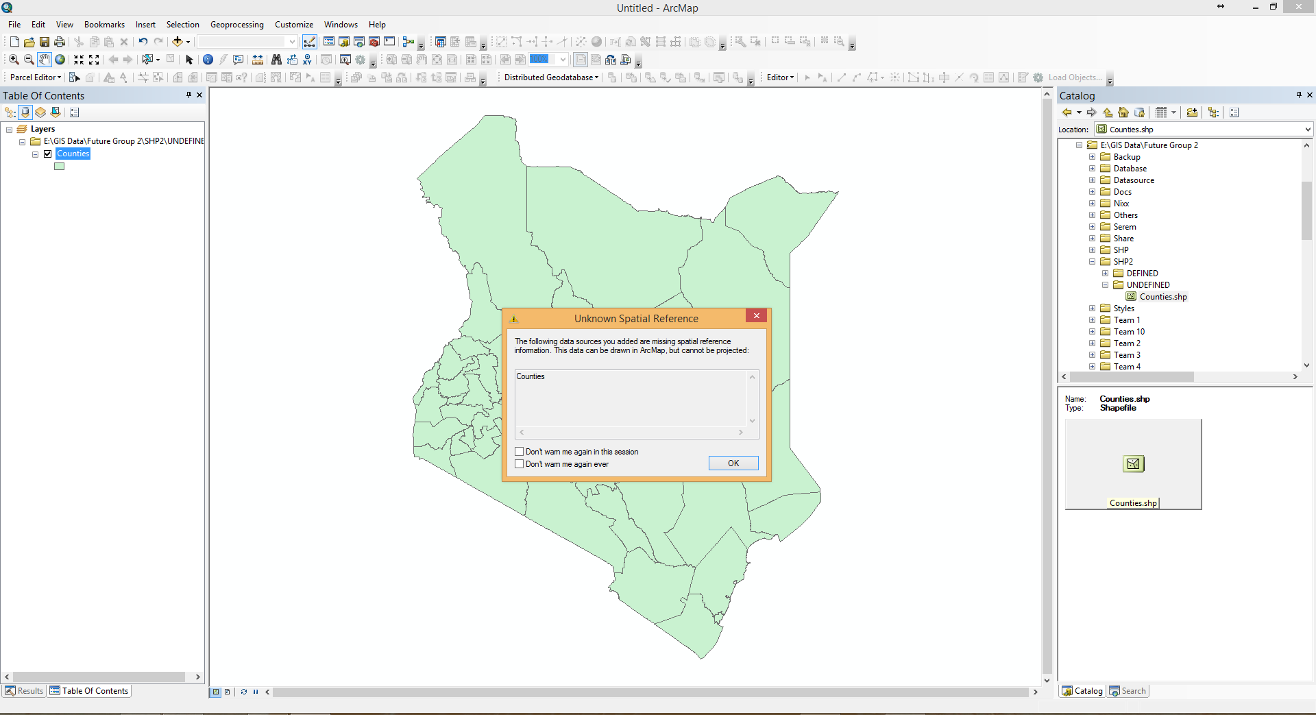
Please download sample zip attached and do the following.
- Unzip the file
- Explode it. You will see two folders
- Launch ArcMap and try loading Counties shapefile under UNDEFINED folder and you will recreate screenshot above.
Then it is at this time you can define the coordinate system of your dataset. Defining coordinate system of the dataset might require that you either lok at the coordinates and from experience analyse and realize correct coordinate system or datum. alternatively you might need to contact the source of your data and seek clarification on the coordinate system of the dataset
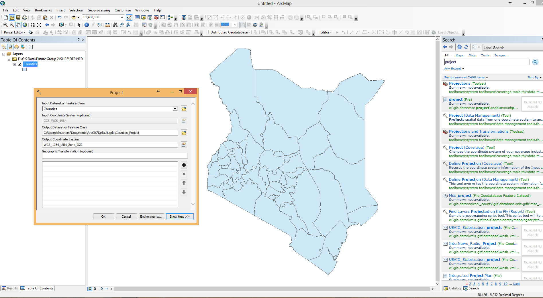
Project (Data Management) Tool
The dataset must have a spatial reference that is recognizable by ArcMap and then you run Project (Data Management) tool to move from one datum or coordinate system to another.
Please download sample zip attached and do the following.
- Unzip the file
- Explode it. You will see two folders
- Launch ArcMap and try loading Counties shapefile under DEFINED folder and run project tool on it
- See screenshot below showing now that you can project (move between datums and coordinate systems either GCS or PCS). for my case i was moving from GSC (WGS 84) to a PCS (WGS_1984_UTM_Zone_37S) but within the same datum.
I hope i have been able explain the difference between Define Projection (Data Management) Tool and Project (Data Management) Tool
- Mark as New
- Bookmark
- Subscribe
- Mute
- Subscribe to RSS Feed
- Permalink
Define Projection (Data Management) Tool
Defining is used when you have datasets that ArcGIS doesnt know the coordinate system or datum they are in. For instance you might receive shapefiles from someone or download them from a certain source and they lack the *.prj file which is the projection file. If you try loading them in ArcGIS then you will get a message undefined spatial reference.
See sample screenshot below;
Please download sample zip attached and do the following.
- Unzip the file
- Explode it. You will see two folders
- Launch ArcMap and try loading Counties shapefile under UNDEFINED folder and you will recreate screenshot above.
Then it is at this time you can define the coordinate system of your dataset. Defining coordinate system of the dataset might require that you either lok at the coordinates and from experience analyse and realize correct coordinate system or datum. alternatively you might need to contact the source of your data and seek clarification on the coordinate system of the dataset
Project (Data Management) Tool
The dataset must have a spatial reference that is recognizable by ArcMap and then you run Project (Data Management) tool to move from one datum or coordinate system to another.
Please download sample zip attached and do the following.
- Unzip the file
- Explode it. You will see two folders
- Launch ArcMap and try loading Counties shapefile under DEFINED folder and run project tool on it
- See screenshot below showing now that you can project (move between datums and coordinate systems either GCS or PCS). for my case i was moving from GSC (WGS 84) to a PCS (WGS_1984_UTM_Zone_37S) but within the same datum.
I hope i have been able explain the difference between Define Projection (Data Management) Tool and Project (Data Management) Tool
- Mark as New
- Bookmark
- Subscribe
- Mute
- Subscribe to RSS Feed
- Permalink
Hi David,
I think I now perfectly understand the difference. Defining is just telling ArcGIS which cordinate system the file already has. Using the project tool is the actual thing, I mean changing the projection to a projected cordinate system. You examples were very helpful.
Thank you.
- Mark as New
- Bookmark
- Subscribe
- Mute
- Subscribe to RSS Feed
- Permalink
Dear Ahmed, i am glad i make a positive impact.