- Home
- :
- All Communities
- :
- Products
- :
- Mapping
- :
- Map Projections Questions
- :
- Re: adding coordinate system to an existing shapef...
- Subscribe to RSS Feed
- Mark Topic as New
- Mark Topic as Read
- Float this Topic for Current User
- Bookmark
- Subscribe
- Mute
- Printer Friendly Page
adding coordinate system to an existing shapefile
- Mark as New
- Bookmark
- Subscribe
- Mute
- Subscribe to RSS Feed
- Permalink
Hello,
as it may seem obvious to many, I did not find anything aiming me to the right direction. At least google and Argis help failed (or I did). Anyway the problem is:
I have a group of points (point shapefile) that I collected in the field. They all has position relationship though they don't contain information about their global coordinates (I didn't have gps unit for that task). However I have cerated 2 points which I also measured their actual coordinates via my personal gps unit. Now I heard it is possible to give the whole project a coordinate system on the basis of several measured coordinates. Ok, maybe 2 coords are not enough, but I can't find any tool to do it anyway.
Now I don't think it would help to add images but to give a general infromation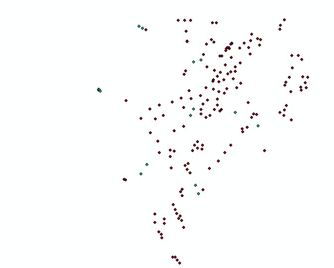
this is (one of) the group of points
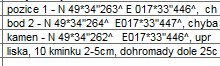
there are coords (in the 2 lines from above).
I know the whole post doesn't make much sense but still, if anyone has a clue how to proceed, I'd be grateful.
- Mark as New
- Bookmark
- Subscribe
- Mute
- Subscribe to RSS Feed
- Permalink
How does the program creates the values of lat an lon when there is only a graphical expression of the data but no coordinates
For point layers using a geographic coordinate system the lat and lon are stored in the Shape field. The graphic on the map is derived from the Shape field data. When you calculate x and y values into other fields, ArcMap gets these values from the Shape data and inserts them into the attribute table.
In the case of your data something appears to be wrong. The calculated lat and lon values do not seem to correspond with the data in your group of points that are all around 49N and 17E.
I have a group of points (point shapefile) that I collected in the field. They all has position relationship though they don't contain information about their global coordinates (I didn't have gps unit for that task).
If you are trying to match the data to the other layer that you collected with a GPS then Anthony is correct and you should use the Spatial Adjustment toolbar. This allows you to select points in your data and link them to their actual location.
Hope this helps,
Owen
- Mark as New
- Bookmark
- Subscribe
- Mute
- Subscribe to RSS Feed
- Permalink
Hello Owen, that clears a bit of my frustration. I thought there is something totaly wrong with the shapefile, though I can't fix it. The software I used to collect data allowed me to only export database but not the shapefile. I had to only copy the whole project that serves it purpose in Arcmap, somehow.
But still I have to add the measured coordinates to those two points. So I try again to join the attr table and the database and will see what happens. Otherwise I dump it all and never care anymore 
- Mark as New
- Bookmark
- Subscribe
- Mute
- Subscribe to RSS Feed
- Permalink
Do you have a common key field in both datasets?
If so you could join the measured coordinates data to the GPS data using this field. This assumes that you have a GPS point for each of your measured points.
Otherwise:
1. Add your GPS points into an empty document in ArcMap.
2. Add your measured coordinates data.
3. Use the Spatial Adjustment toolbar to fit your data to the known GPS points.
- Mark as New
- Bookmark
- Subscribe
- Mute
- Subscribe to RSS Feed
- Permalink
Ok, so I tried the spatial adjustment you've been advising me to use. I would say it helped. Thanks, I think that solved my problem and I feel ashamed for not realising to put my measured gps data straight into Arcmap via csv or something. Anyway I came across a problem of mine, I was having ever since I tried to use any gis software. Yes I sometimes think I should stop using gis when I can't resolve this, but it kept me occupied when using freeware Qgis and as well now in Arcmap.
I searched through the internet, and there is so much and yet so little about the problem, that I am on the edge of freaking out. I am sorry, but if may ask for another help, it would make my life easier, otherwise I am done.
The problem:
I come from Czech Rep where it is mandatory to use S-JTSK east north projected crs instead of WGS84 which makes everything squashed. But there was alway a problem for me to add a gps data, that use WGS84 crs, into a gis software and reproject it either on the fly or by any tool to the S-JTSK (EPSG 5514, former ESRI 102067) so that a point shapefile and an aerial imagery match up.
I tried it several ways today and none was successful. I tried projecting it on the fly. I tried to use a data management project tool, I also read somewhere that Arcmap behave in a way, that the first layer with crs added become a parent - and software makes following layers added later reproject on the fly to the parent one. I tried that. Nope.
I also tried to use this method ArcGIS Coordinate Transformation - YouTube, as I was quite conviced S-JTSK and whatever crs the author of the video was using, behave in a similar manner. Well it didn't went well either.
Now I have a standalone small programe to convert WGS84 coords to S-JTSK one by one (so it is a fiddly job, although my gps contain only 3 points in total  ) but I cannot use it in csv as Arcmap doesn't accept such data (it's not decimal but in meters).
I hope I didn't get you bored. And if I didn't thanked for the help with the previous problem till yet, I thank you now. And if I did, another prasie doesn't hurt anybody.
- Mark as New
- Bookmark
- Subscribe
- Mute
- Subscribe to RSS Feed
- Permalink
Lukas - firstly, I would encourage you to persist with using GIS as it is such a useful tool in so many ways.
In regards to the projection problem - It sounds like ArcMap does not know what coordinate system your data is in.
If you view the layer properties for your data points can you check if the coordinate system:
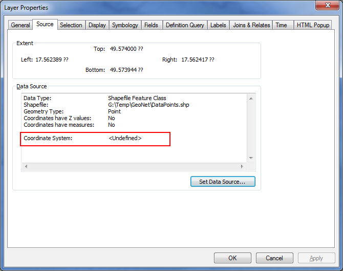
If this has not been assigned to the layer then ArcMap will not know how to project the data or do on-the-fly transformations. If this is the case the Coordinate System will show <Undefined>.
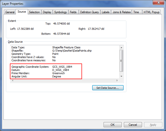
You can use the Define Projection tool to assign the WGS 1984 Geographic Coordinate System to this layer (ArcToolbox: Data Management Tools > Projections and Transformations > Define Projection).
After defining the projection the layer properties should have been updated:
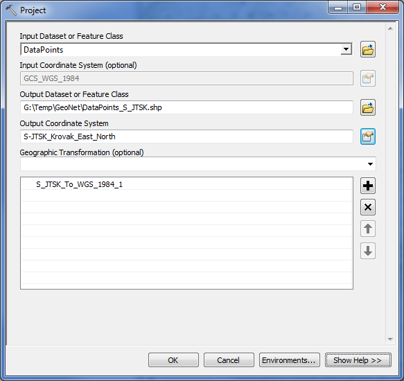
You should now be able to project your data points to S-JTSK using the Project tool (ArcToolbox: Data Management Tools > Projections and Transformations > Feature >Project):
- Mark as New
- Bookmark
- Subscribe
- Mute
- Subscribe to RSS Feed
- Permalink
Hi Owen, thank you for your reply. I made a video (do not go over 6:52 haha) of doing what you're advising me to do. Yes, the point shapefile didn't have crs defined, so I defined it, then tryed to reproject to another one. Still the layers are not matching up. Well, clearly I do an obvious mistake, well not obvious to me though.
- Mark as New
- Bookmark
- Subscribe
- Mute
- Subscribe to RSS Feed
- Permalink
QGIS and ArcGIS are probably even more confusing because they're using American conventions for some things.
One of the first things I noticed is that when you used the Add XY Data tool, you left the columns set to "x" = "x" and "y" = "y". The problem is that the data has the "x" column containing latitude values and the "y" value containing the longitude values. In ArcGIS, "x" = easting = longitude and "y" = northing = latitude. Notice that even when using a projected coordinate reference system like Krovak, x = easting and y = northing. I know that's not always the standard in Europe.
I didn't watch the rest of the video, because the data's already messed up!
Melita
- Mark as New
- Bookmark
- Subscribe
- Mute
- Subscribe to RSS Feed
- Permalink
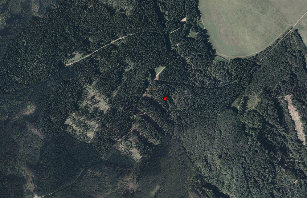
Hello Melita, I don't know about other countries, but Krovak system actualy works in third quadrant and both axis are negative and moreover y axis is in the position of the usual x axis and vice versa. Anyway, I tried to create a point .shp out of coords with inverted x and y coords and, wait for it, it worked. So, thanks for the tip and thank you all who contributed to the overall success.
It just took me 3 and a half year to get i right.............not bad
And here's a proof that it actually works.
- « Previous
-
- 1
- 2
- Next »
- « Previous
-
- 1
- 2
- Next »