- Home
- :
- All Communities
- :
- Industries
- :
- Transportation
- :
- Logistics
- :
- Logistics Questions
- :
- Coverage of Polylines Within a Polygon
- Subscribe to RSS Feed
- Mark Topic as New
- Mark Topic as Read
- Float this Topic for Current User
- Bookmark
- Subscribe
- Mute
- Printer Friendly Page
- Mark as New
- Bookmark
- Subscribe
- Mute
- Subscribe to RSS Feed
- Permalink
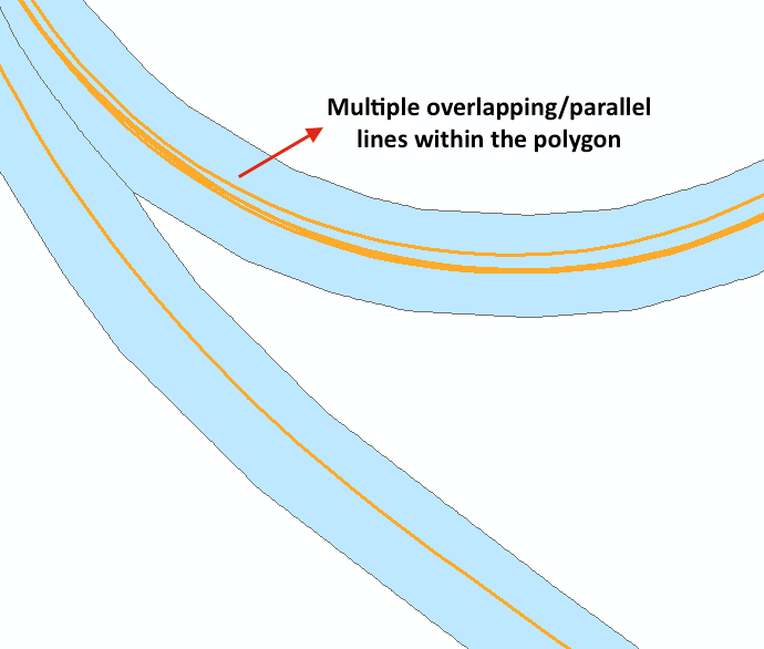
Is there a way to calculate the coverage of polylines within a polygon when there are overlapping lines and parallel lines? I am working on finding route coverage of gps traces within a centerline route buffer, but ran into the issue of having multiple traces that run alongside each other, overlap, or have gaps. The result is numerous short polylines within the route polygon and no way of calculating if the lines provide full coverage of the route extent. For example, I have a route polygon that is 27 miles long, and has 56 polylines within it and the sum of the lines are 126 miles. Is there a way to get a mileage total of the lines without summarizing the overlapping/parallel lines also?
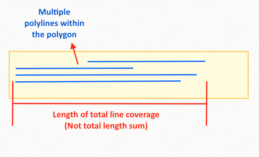
I am looking for coverage parallel to the X axes. So just the overall length coverage that the lines provide within the polygon, total length covered rather than total sum of all lines.
I am using ArcMap 10.5, advanced license, no extensions (Network Analyst) being used.
Solved! Go to Solution.
Accepted Solutions
- Mark as New
- Bookmark
- Subscribe
- Mute
- Subscribe to RSS Feed
- Permalink
I was able to figure this out via a suggestion to try using Integrate to snap the lines together, then Dissolve to merge the stacked lines into a single line. This allowed me to get the total length the lines covered.
- Mark as New
- Bookmark
- Subscribe
- Mute
- Subscribe to RSS Feed
- Permalink
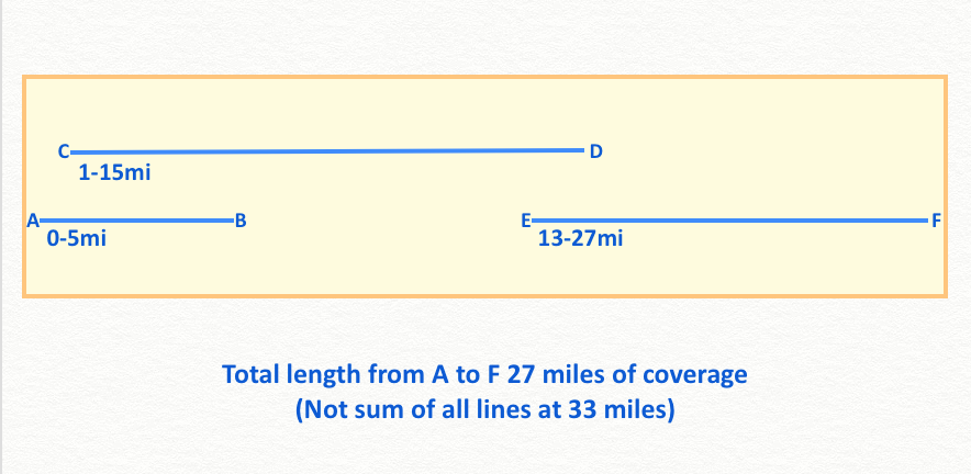
From your simple example, it looks like you need to select/clip the polylines then obtain the min and max points of each polyline. Taking the min and max of those should give you the horizontal and vertical coverage. This suggestion differentiates itself from obtaining the start and end point as in the case of a purely horizontal set of lines as shown in your 2nd image (ie… consider all lines forming parallel L 's or I 's.
You might want to clarify whether you 'coverage' needs are solely parallel to the X and/or Y axes
- Mark as New
- Bookmark
- Subscribe
- Mute
- Subscribe to RSS Feed
- Permalink
I was able to figure this out via a suggestion to try using Integrate to snap the lines together, then Dissolve to merge the stacked lines into a single line. This allowed me to get the total length the lines covered.