Say Hello to LocalMaps 2.1!
- Subscribe to RSS Feed
- Mark as New
- Mark as Read
- Bookmark
- Subscribe
- Printer Friendly Page
The day has come team - LocalMaps 2.1 is here! Chock full of some great new features, even more administration capabilities and lots of helpful UI enhancements, this release is one you won’t want to miss! Check out below for some key updates (This blog builds on a pre-release update from Grant).
Just a note that this is not full list - just our favourite picks for you. Check out the full release notes in our NEW Documentation System! Read more on the new guides below.
GALLERY
Restricted Content
For Organisations wanting to use LocalMaps as a central destination for all content, that is, accessing both general content as well as secure content – you can now do just that. With Version 2.1, members of your organisation can log in and see the maps shared with the organisation but also content that is applicable to just them.
Link to a Category
Want to send a link to the LocalMaps Gallery but focused on one category of Maps? You now can by appending
?c=CATEGORYNAME to the gallery URL.
VIEWER
We have brought in some great enhancements to existing widgets in Version 2.1 as well as introducing a couple of new widgets to look out for!
NEW Popup Panel
For those of you that have taken full advantage of LocalMaps Feature Queries we know that sometimes there is a lot to squeeze into one popup - which is why in 2.1 you now have the option to use the popup side panel. Now all your great feature queries are easy to view and scroll through and if you have any attached images, these can be viewed directly in the panel (rather than opening a new window).
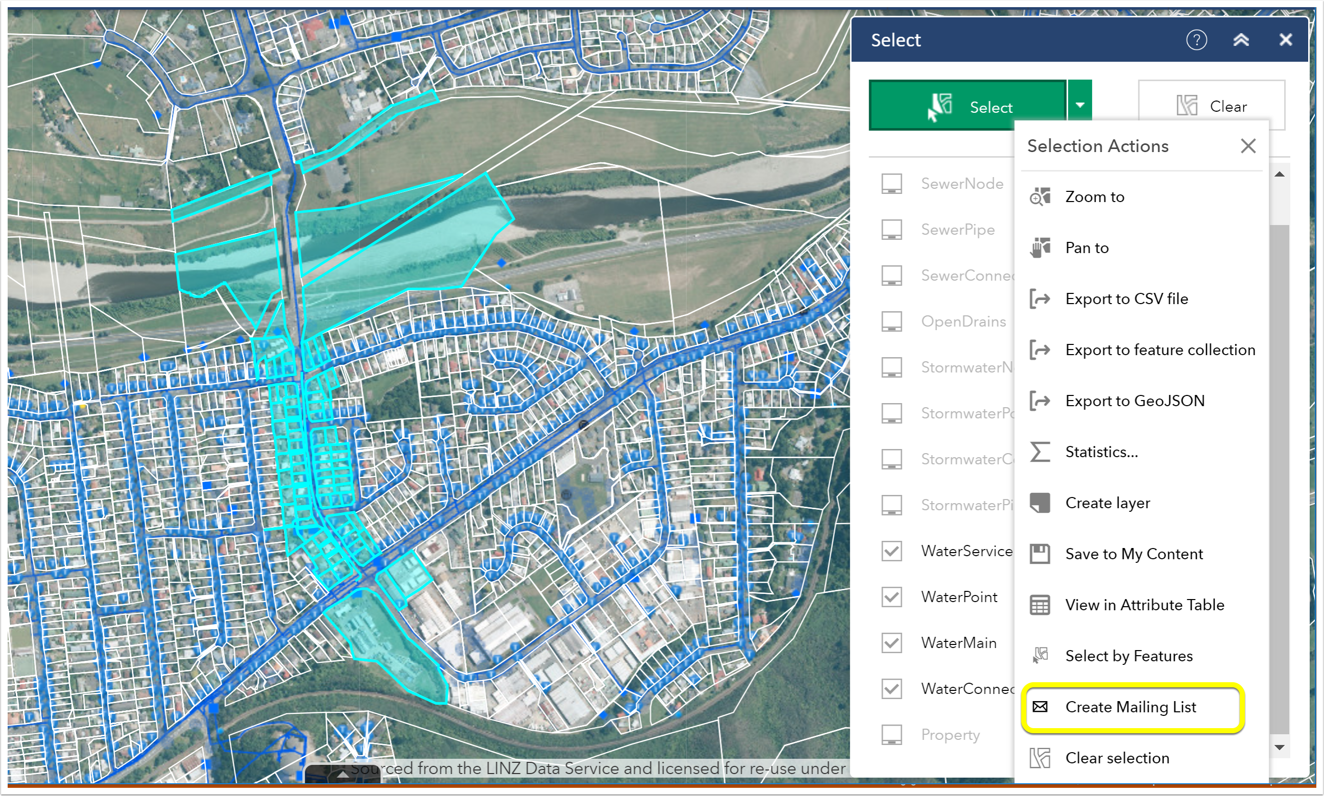
NEW Mailing List
The Mailing widget (otherwise known as the out-of-the-box Public Notification widget) is a new feature in LocalMaps that allows users to identify a collection of properties and create mailing labels, or a structured text file of owners and occupants. This type of workflow might be useful for planning and zoning departments, but it can be used by any organization looking to notify property owners or occupants of a formal action being taken.
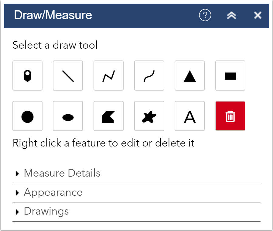
Draw / Measure
You spoke, and we listened! Thanks to some great feedback on Geonet we have resigned the Draw / Measure tool to provide a much more intuitive user experience. In Version 2.1 you now have a simple step through process with collapsible sections for Measure details, Appearance and Drawings. You can now also export any drawing as GeoJSON.
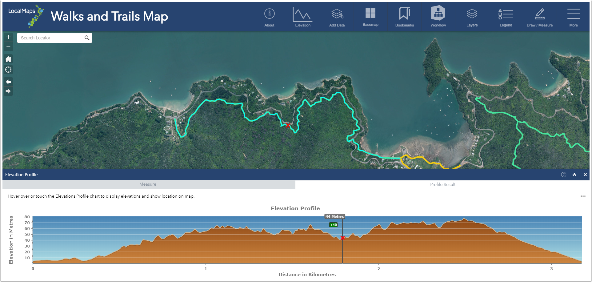
Elevation Profile
The 2.1 Elevation Profile widget has been enhanced so you can now choose to either draw a line or select a line to use to generate a profile.
Save
You can now log into LocalMaps from within the Viewer itself. Log in using your ArcGIS Named User, or (if enabled) Facebook or Google credentials. From here, you can Save maps with a different map extent, layers visible or graphics drawn. This can then be kept private or shared with another person.
Workflow 5 Integration
Organisations using the Geocortex Workflow 5 by Latitude Geographics now have the option to run those same Workflows from within the LocalMaps Viewer. Geocortex Workflow 5 is a solution offering that provides an easy way to automate business processes.
See release notes for more new features & resolved issues in the Viewer.
ADMINISTRATION
The LocalMaps administration tools have had some great enhancements brought in as well as a few new pages!
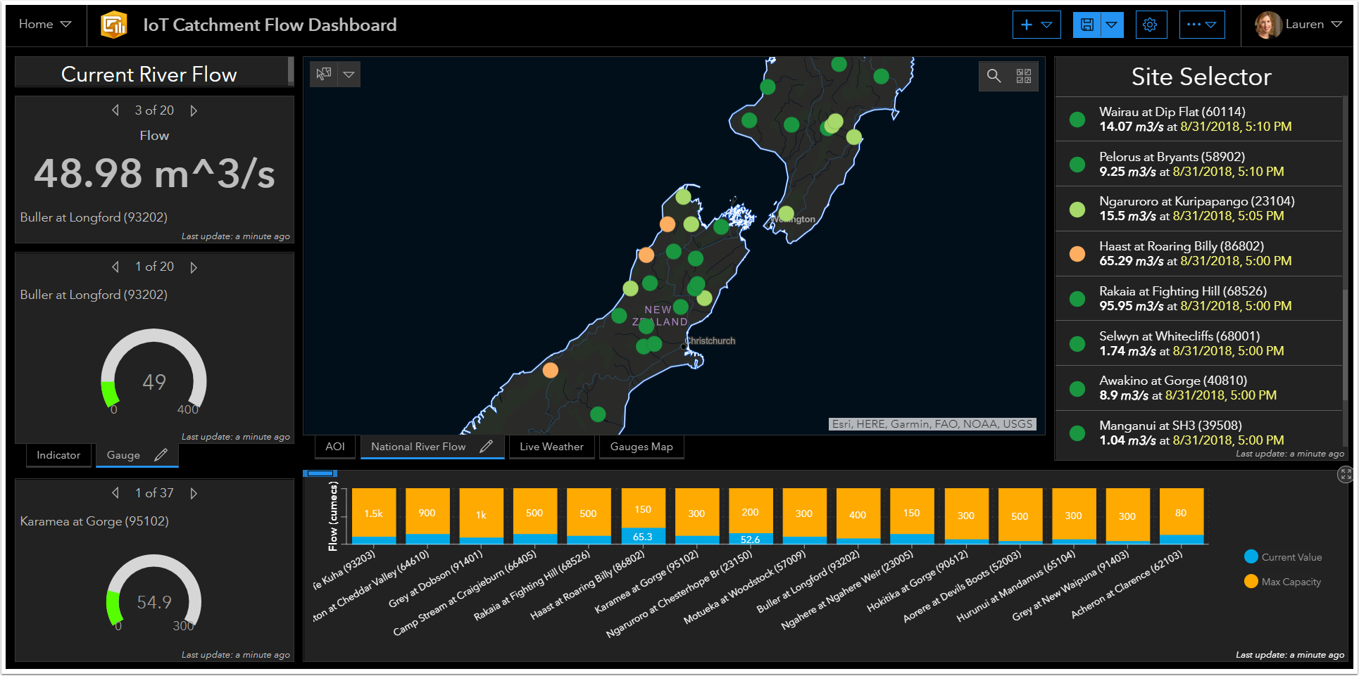
NEW IoT Layers
Previously called Hilltop, this section allows you to pull in a display live data from a variety of Sensor API's for monitoring environmental data. IoT layers can include sites or collections from a Sensor Observation Service and/or Hilltop and can be set to periodically return the latest measurements. When you first create an IoT layer, LocalMaps adds it as a new item directly into your ArcGIS or Portal contents. You can then view and query in your webmaps and web applications – like this dashboard containing an IoT layer on Flow data across NZ.
Updates and Enhancements:
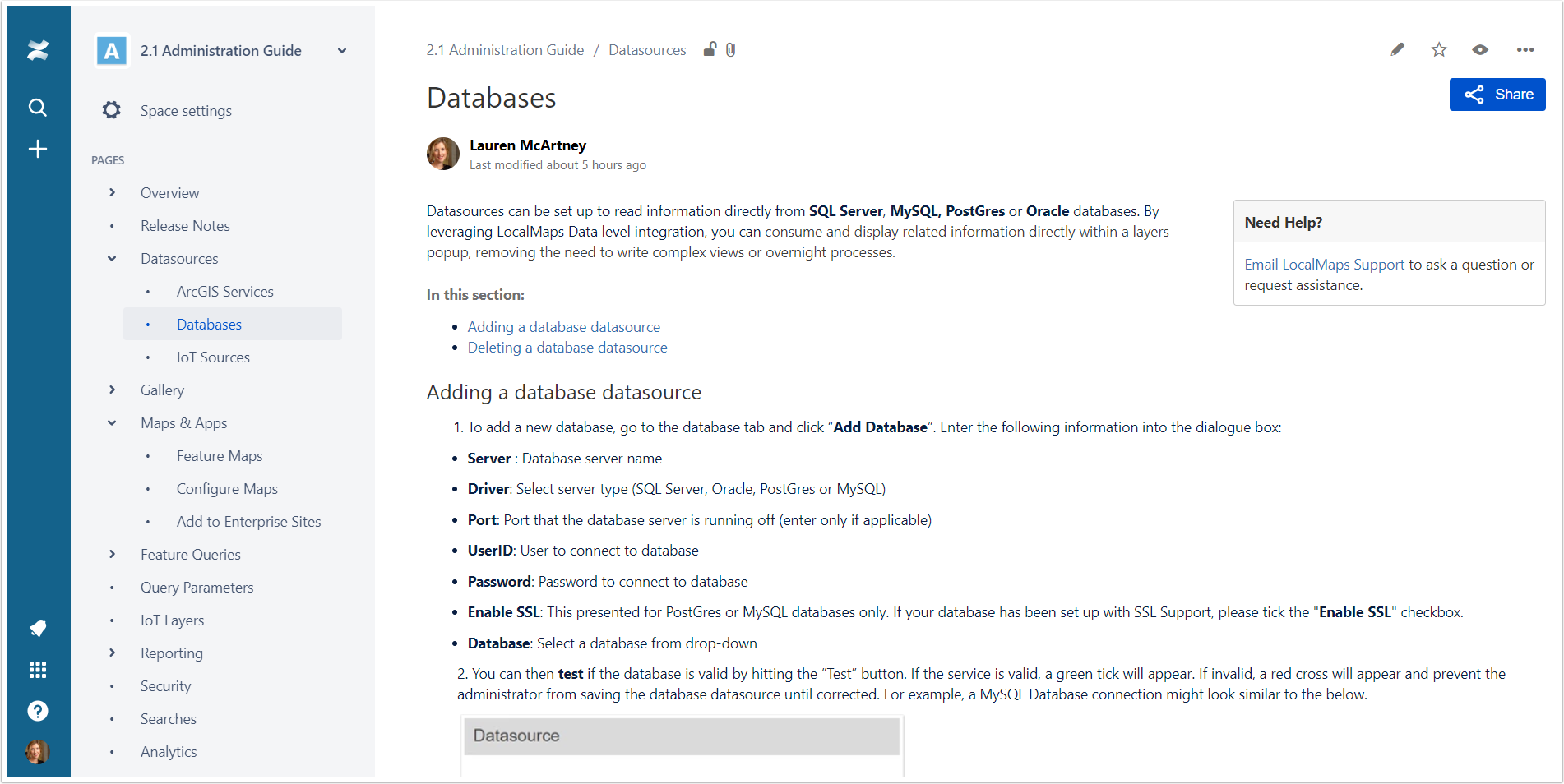
Datasources
- ArcGIS Services: In Version 2,1 we now support indexing of secure services from ArcGIS , ArcGIS Enterprise or a standalone ArcGIS server. These can then be used throughout the rest of LocalMaps Administration configuration in searches, reports, feature queries etc.
- Database Datasources: You can now connect directly to your SQL Server, MySQL, PostGres and Oracle Database tables or stored procedures. These can be used in the same method as above throughout the configuration of LocalMaps.
- NEW IoT Sources: This section (previously called Hilltop) lets you connect directly to a variety of Sensor API's for monitoring environmental data. Within Version 2.1 we support both Sensor Observation Services (SOS) that can return WaterML2 and also services from Hilltop Server.
Gallery
- UI changes to combine about text and styles into one page.
- New HTML Editor for the About Text section.
Maps & Apps
- Set a map to be a Feature Map from the LocalMaps Administration page now (instead of going into ArcGIS or Portal for ArcGIS and adding a tag).
- Widget icons have been converted to fonts to allow administrators to set the colour of widget icons.
- For Organisations on ArcGIS 10.6.1 who are looking to use ArcGIS Enterprise Sites but still want to have the functionality contained in the LocalMaps Viewers, you can create a group to use in the Gallery card when building an Enterprise Site.
Settings
- Ability to set the default Map sort for the Gallery
- Enable the Popup Side Panel – this is universal across your LocalMaps Viewers.
- Set text for Splash screen widget.
See release notes for more new features & resolved issues in the Administration Tools.
DOCUMENTATION
NEW Administration and User Guides
As we bring even more functionality into LocalMaps, we recognize that there is quite a lot of take in – and a PDF document just won’t cut it anymore. So, we have created brand new Administration and User Guides for easier access to LocalMaps Documentation.
User Guide
To make things easier for your users this guide outlines each widget with step by step instructions on how to use it. Even better, each widget help page is accessible just by clicking on the help icon in the widget header. Check it out here.
Administration Guide
Packed with step by step instructions, tips and examples this guide is a go to for all things configuration related! Check it out here.
Get Version 2.1 now!
To install or upgrade to Version 2.1 email your Eagle Account Manager.
As always, let us know what you think about Version 2.1 and what we could bring into future releases. Add your suggestions and ideas up here on Geonet or get in touch with the LocalMaps Team – Lauren McArtney ([email protected]) and Grant Carroll ([email protected]).
Thanks!
The LocalMaps Team
You must be a registered user to add a comment. If you've already registered, sign in. Otherwise, register and sign in.
-
Announcement
10 -
Announcements
6 -
Experience Builder
1 -
LocalMaps
17 -
New Zealand
2 -
Reporting
1 -
Reports
1 -
v2.3.2
1 -
v3
6 -
v3.1beta
1 -
Widgets
1