LocalMaps NZ Blog - Page 4

cancel
Showing results for 
Show  only  | Search instead for 
Did you mean: 

Latest Activity

(32 Posts)
LaurenMcArtney
Esri Contributor

Wait’s over team, LocalMaps 2.0 is now available.

As our major release for the year, 2.0 is filled to the brim with new features, greater administration capabilities and various UI enhancements. Scroll down to see some of the key updates and keep an eye out here for our new 2.0 video guides coming soon.

NOTE: the below is an overview of key features in this release. See the Version 2.0 full release notes and Functionality matrix for more detail.

LocalMaps Viewer 

With Version 2.0 we have enhanced several of the existing widgets, brought in the Add Data widget and in some cases updated widgets with Esri’s OOTB tools. As Local Maps is closely aligned with Web AppBuilder this means that as Esri release new versions of these widgets, we can just plug them into LocalMaps. 

Widget updates

Select

Updated to Esri’s OOTB Select tool however, administrators can now additionally enable Advanced Select tools for selection by attribute and / or feature. 

Draw / Measure

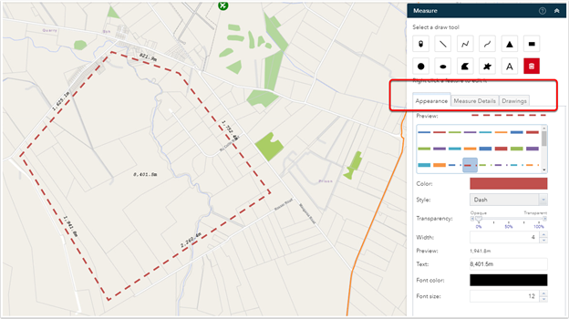
Leveraging the best of both tools, LocalMaps has combined the OOTB Esri Draw and Measure widgets into one powerful tool. Users now have interactive measurements shown whilst tracing line/shape, the option to include bearing measurements, a fixed radius and line segment lengths.
Zoom to Point
Capture and convert coordinates – NZTM, NZMG, WGS84

Switch Map 

Filter map to switch to using tags or titles.

Basemap & Share widgets

Updated to Esri OOTB.

NEW - Add data

Add data from an ArcGIS online group, file or URL


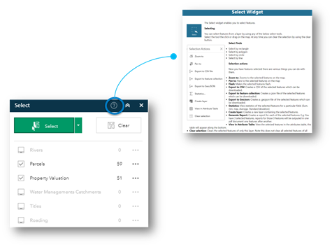
NEW - Widget Help

Users can now see step by step how to use a widget in LocalMaps by clicking the info icon located in the top right of the widget header.
LocalMaps Theme for Web AppBuilder 

This release now includes a new LocalMaps Custom theme for Web AppBuilder for ArcGIS. This gives organizations the flexibility to build their own Web Apps, bring in specific widgets outside of the core LocalMaps widgets while maintaining the consistent styling of the LocalMaps viewer. 
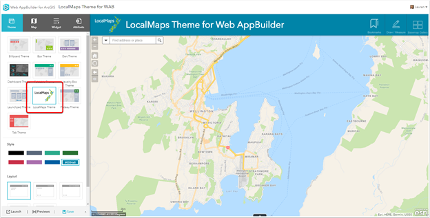


The LocalMaps theme will be available to download from the LocalMaps Community Page along with instructions on how to build your own Web AppBuilder.


Administration

The LocalMaps administration tools continue to grow giving you even greater flexibility when configuring your LocalMaps site. Below are some of the key new tools and enhancements.

NEW sections:

Hilltop

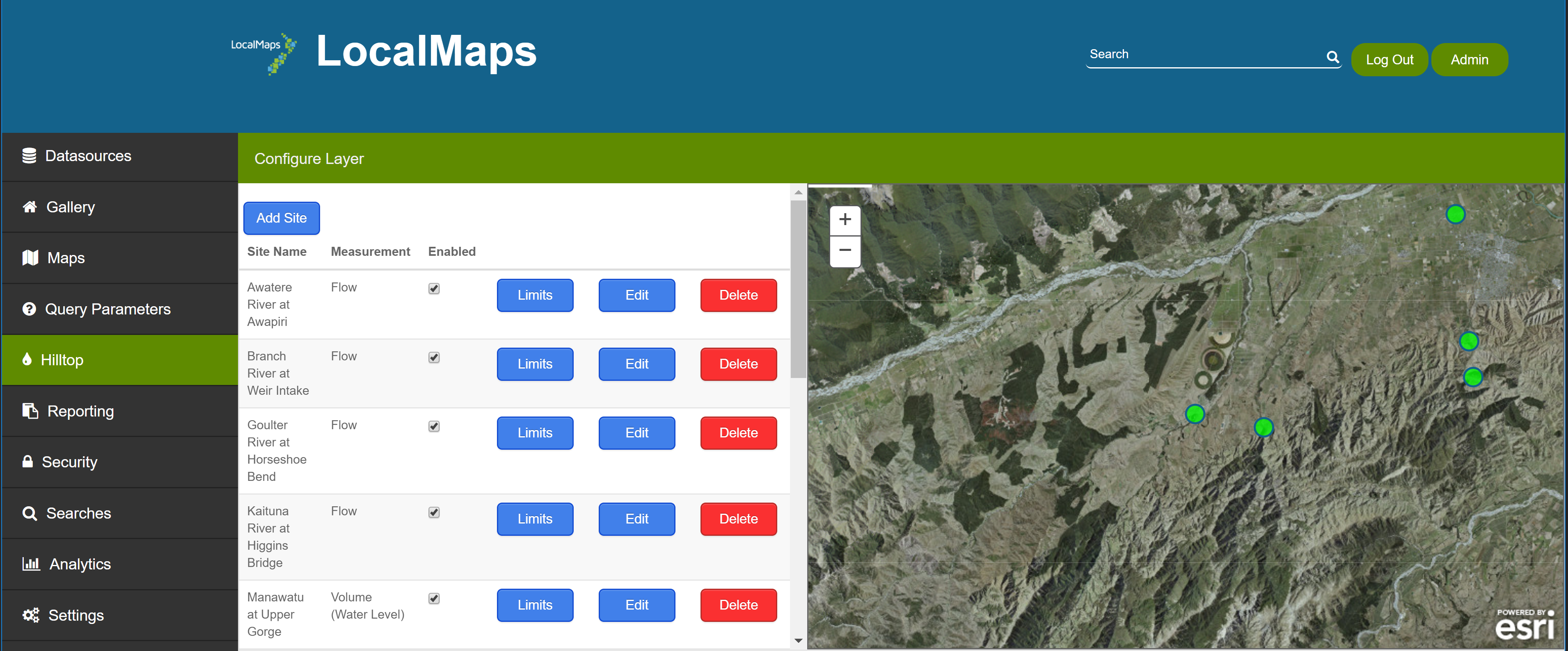
Hilltop software is used in New Zealand by regional councils, electricity companies and consulting engineers for storing and analyzing environmental data. The Hilltop section in LocalMaps allows you to pull data from Hilltop Server and create a new hosted feature layer to view and query in your webmaps and web applications.


When you first create a Hilltop layer, LocalMaps also creates a new folder in your ArcGIS Online or Portal Organization called “Hilltop”. Any new Hilltop layers you create through the LocalMaps administration page will be indexed here. These can then be added to a webmap and subsequent Web Application.

Feature Queries

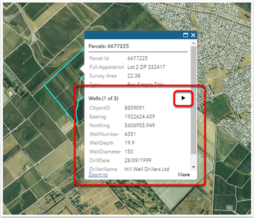
A brand-new addition to LocalMaps are Feature Queries. Feature Queries give you the ability to view additional information about a property that doesn’t exist on the layer itself. Essentially, you are creating a related record on the fly and then displaying this information in a layer’s popup.

For example, in the below image a feature query has been configured to display the number of wells that intersect with this parcel. If there are multiple wells, you can scroll through and view the attribution by clicking the arrow button. If there are no wells that intersect this parcel, the popup will show only the parcel attributes as set up in the webmap.


Analytics

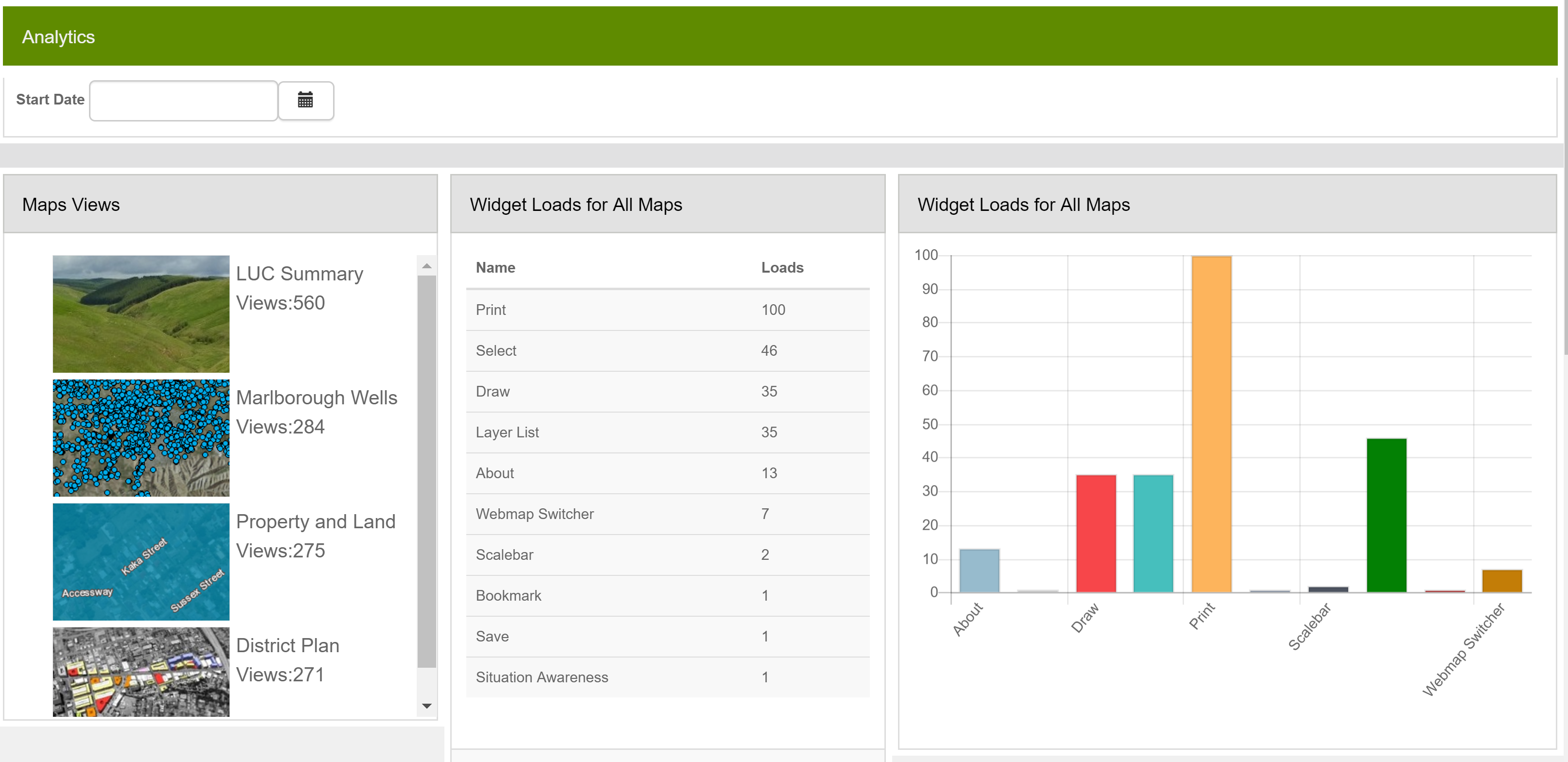
This section lets you quickly and simply see how people are using LocalMaps, what maps are most popular, what widgets are most popular and who are your heavy users.

Contents analytics provides administrators with insight into what maps are being loaded, how many times they have been viewed and when as well as what widgets are being used.
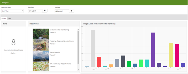
The User analytics tab delves deeper into who is logging into LocalMaps and when along with what maps they are viewing most regularly.          

Updates and Enhancements:

Reporting

  • Dynamic text reports. Dynamic text reports allow you to use placeholders with specific syntax that the LocalMaps reporting engine understands. When a report is then generated, LocalMaps will replace your placeholders with real values and give you a nice printable document back.

Datasources

  • Add SQL or Oracle Databases
  • Add Hilltop Servers

Maps & Apps (Previously Maps tab)

  • Web apps can now be feature maps too
  • Click on Map thumbnail to launch viewer directly from Admin
  • Assign a Widget to open on map launch
  • Order how widgets appear in the map toolbar
  • Set map to be default e.g. the viewer URL will go to this
  • Enable the Advanced Select Widget

Get Version 2.0 now!

Now we know there is a lot to take in in this release so make sure to check out the new Administration and User “How-to” videos coming soon as well as the release notes and updated documentation – all available right here on Geonet. To install or upgrade to version 2.0 contact your Eagle Account Manager.

The LocalMaps Team, December 2017

more
2 0 544
LaurenMcArtney
Esri Contributor


It was great to see many of our LocalMaps Users at the New Zealand Esri User Conference last week! For those you who made it to the Local Government Special Interest Group, it was especially beneficial to hear your thoughts on LocalMaps 1.1 and discuss the development roadmap going forward with version 2.0 coming out later this year.

As a follow up to this, below is an outline some of the main improvements in LocalMaps 1.1 that were shown at conference. These include greater reporting capabilities, new Save Map and Draw Widgets as well as several bug fixes and enhancements to existing widgets. We also gave a bit of a sneak peek into what is coming in 2.0 - scroll down to check out what to expect!

Our development is driven from you so if you do have any ideas, please feel free to pop them up here on Geonet!

---- What’s New in 1.1 ----


Reporting


There have been a number of improvements to the Report tool and administration. Now in the admin tools administrators can easily view, edit and create advanced reports. By simply selecting a feature in the LocalMaps Viewer, users can then generate a PDF document containing multiple maps, tables and related information. Key new features:


  • Build multi-page reports from a single input feature
  • Include multiple maps and map layouts
  • Add maps, tables and text statements based on a selected feature and linked tables.
  • Move, order and reposition elements in the report
  • Configure buffers and other spatial features
  • Select from predefined templates or upload you own to ArcGIS Server to use.

 
If you would like to test this and any of the other new tools below, please site head to the LocalMaps for Local Government demo page  (To test the reporting, launch the Land Use map from the gallery. You can then select a parcel and hit the “Generate Report” Button.)

Example of reporting administration 


Save Map


Save edits and selections made to any map with the new Save Widget. Saved maps can then be shared with others through a url. This functionality is currently only available in LocalMaps using Portal for ArcGIS (Coming to ArcGIS Online build in August)


Draw / Measure


The LM draw / measure widget has been updated to include more options to edit vertices, move, resize, delete and measure drawn shapes.


Enhanced Select


Improvements to the Select tool include adding a buffer radius on the map when a selection is made. We have also addressed various bug fixes.


Zoom to point 


Capture co-ordinates using the zoom to point widget rather than using the co-ordinates widget itself.


Training and Support


We also have a new LocalMaps Administration Training course. Designed for administrators, this one-day instructor lead workshop teaches how to successfully manage a LocalMaps install in parallel with customers ArcGIS Online subscription account and Enterprise GIS installation. More info here.


---- LocalMaps 2.0 - What's coming ----


We have several new developments we have included in LocalMaps 2.0 (release due Nov 2017). These include-

  • Social logins 

      Sign into LocalMaps using your ArcGIS Online or Portal for ArcGIS, Facebook, Google or Datacom. More providers       to come. 


  • UX/UI Enhancements 

      The LocalMaps administration page has have various UI/UX enhancements including new drag and drop functionality, formatting fields in for your reports, ordering fields in your reports, adding in default searches and the ability to have separate logos for your gallery and viewer


    • Analytics 

    You will now have the ability to see how maps and widget are being used within LocalMaps. We are capturing when a map is loaded and also when a widget is loaded as well. For those users who have logged in, we will also capture this information too. This lets you quickly and simply see how people are using LocalMaps, what maps are most popular, what widgets are most popular and who are your heavy users.


      • Hilltop integration 

      Most regional councils in New Zealand are running Hilltop Server, this is a server that provides environmental information out to the internet. With the Hilltop integration and associated widget, you can start to surface this information through your Portal and ArcGIS Online. The widget lets you interrogate the data return data for given time periods and even allows users to export sample data to CSV, or save images of the graphs within the widget.

    • LocalMaps Web AppBuilder Theme 

    Have a consistent look and feel across all your content in LocalMaps – webmaps and webapps! We will be releasing a new LocalMaps Theme that can be used with your other Web Apps built with Web AppBuilder (Developers Edition) 


    Future LM development’s is heavily based on feedback from you - the LM Community. This Geonet page is a core part of this so that you can pitch ideas, feedback and start LM community discussions. Its also a great place to check out what others are saying and vote on those too. Ideas with the highest votes will be first in the development pipeline!

    Stay tuned for more updates to come - 2.0 is just around the corner! 


    The LocalMaps Team, August 22nd 2017

    more
    3 0 617
    78 Subscribers