- Home
- :
- All Communities
- :
- User Groups
- :
- LIDAR Resources
- :
- Questions
- :
- Re: how to measure canopy height from a DSM raster...
- Subscribe to RSS Feed
- Mark Topic as New
- Mark Topic as Read
- Float this Topic for Current User
- Bookmark
- Subscribe
- Mute
- Printer Friendly Page
how to measure canopy height from a DSM raster minus DEM raster?
- Mark as New
- Bookmark
- Subscribe
- Mute
- Subscribe to RSS Feed
- Permalink
I have a client who has LiDAR data for high voltage transmission lines. They want to be able to calculate the canopy height in areas near the transmission towers. I followed the link here: ArcGIS Help 10.1 to generate rasters of the DSM and DEM from the LiDAR data. I used the GP minus tool to subtract the DEM raster from the DSM raster. Now I'm wondering how to find the canopy height from this. Should I use the 'Profile Graph' tool on the '3D Analyst' toolbar? It seems that the 'Point profile' tool would work a lot better, but it isn't enabled.
Thanks
- Mark as New
- Bookmark
- Subscribe
- Mute
- Subscribe to RSS Feed
- Permalink
Hi Ted, the DSM should be the first returns, or canopy top, and the DEM should be the last returns, or bare earth. The difference between the two would be the canopy height, so it sounds like you already have it. Are you just wondering how best to display the information? What is the client requesting? A shapefile, or something else?
- Mark as New
- Bookmark
- Subscribe
- Mute
- Subscribe to RSS Feed
- Permalink
By the way, the profile graph would require the 3D analyst to be authorized/enabled, but I don't think that what you're looking for--it makes an elevation profile of a line feature.
- Mark as New
- Bookmark
- Subscribe
- Mute
- Subscribe to RSS Feed
- Permalink
Here's a section of the image which is the DSM minus the DEM.
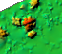
The red area seems to be a tree and I use the interpolate line tool to draw a line through it and get a profile graph shown below
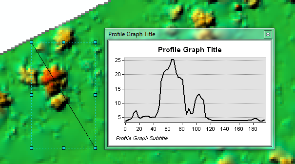
This indicatest that the tree is about 25 feet above the ground. Is this the best way to determine canopy height from a DSM minus a DEM? The point profile interactive tool seems like it would work better but it's not enabled. It's available from the 'profile graph' button on the 3d analyst toolbar. The 'point profile' tool is described here: ArcGIS Help 10.1
- Mark as New
- Bookmark
- Subscribe
- Mute
- Subscribe to RSS Feed
- Permalink
I Guess I don't really understand the question. The DSM minus the DEM IS the canopy height. The values of the raster you created are the canopy height values. You could turn this into points, lines, polygons, even charts, whatever you want. If you can describe exactly how you need your result displayed, I'm sure we can help you get there.
- Mark as New
- Bookmark
- Subscribe
- Mute
- Subscribe to RSS Feed
- Permalink
On a spot by spot basis, you could always use the identify tool to get your pixel value for individual pixels, which would be the height of the object at that point. I tend to call a DSM minus a DEM a Digital Height Model(DHM) for it is the height of the objects scanned above ground(bare earth).
Differentiating between trees and other high features can be challenging, though research has been done for classifying different feature types from LiDAR. If all they need are to be able to get the heights on a case by case basis, then the DHM and the identify tool to get the pixel value would be all they need.
- Mark as New
- Bookmark
- Subscribe
- Mute
- Subscribe to RSS Feed
- Permalink
Yes, exactly!  Another possibility is to buffer the transmission lines, convert the canopy height to polygon, and intersect it with the buffer, or do some zonal statistics along the buffer to get max heights, etc. It really depends on how your client has asked the heights to be delivered, Ted.
- Mark as New
- Bookmark
- Subscribe
- Mute
- Subscribe to RSS Feed
- Permalink
Really I think that utility companies are more worried about how close to transmission lines are to forest canopies than anything. I know we have to go and trim down or remove trees in our transmission Right of Way(ROW) on a regular basis(I'm not involved in this but I know it is something that is done regularly). So I think they would be more interested to know if they are in the ROW as Sephe mentioned and how high each feature was. It would be fairly easy to use a Conditional Statement in the raster calculator to extract pixels of minimum height(say 10,15 feet or whatever they were interested in) that would be deemed features that need to be looked at for cutting/removal in the future.
- Mark as New
- Bookmark
- Subscribe
- Mute
- Subscribe to RSS Feed
- Permalink
Yes, I would imagine trees over a certain height, within a certain distance. This would be fairly easy to calculate, Ted, if that's helpful. Let us know.
- Mark as New
- Bookmark
- Subscribe
- Mute
- Subscribe to RSS Feed
- Permalink
Thank you all for your help. I'll be showing the DHM to the client soon and see what they say. Thanks again.