- Home
- :
- All Communities
- :
- Industries
- :
- Land Records and Valuation
- :
- Land Records and Valuation Questions
- :
- Issue using COGO ArcMap vs ArcPro
- Subscribe to RSS Feed
- Mark Topic as New
- Mark Topic as Read
- Float this Topic for Current User
- Bookmark
- Subscribe
- Mute
- Printer Friendly Page
- Mark as New
- Bookmark
- Subscribe
- Mute
- Subscribe to RSS Feed
- Permalink
I need to verify that parcel geometry closes within a 1' margin of error. I use the traverse tool to input bearings and distances. Recently I ran into an issue where the boundary did not close using ArcPro but it did close using ArcMap. Has anyone else run into problems using COGO/Traverse like this? If I were relying on ArcPro alone, I would have sent it back to have the boundary survey re-done because it did not close when in ArcMap it closes just fine and would not have been sent back.
Anyone else run into the same issue?
What may have caused this?
Solution?
ArcMap 10.7.1
ArcPro 2.4.1
Solved! Go to Solution.
Accepted Solutions
- Mark as New
- Bookmark
- Subscribe
- Mute
- Subscribe to RSS Feed
- Permalink
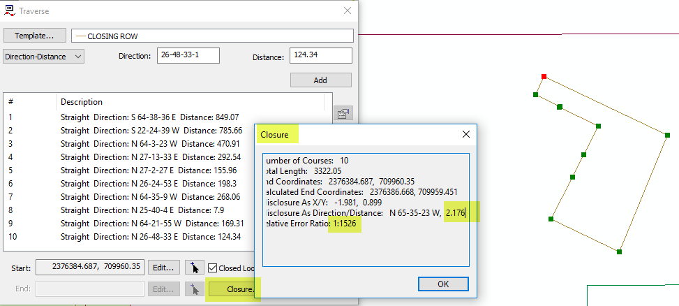
Hi Drew, I've tested your COGO values in ArcMap, and I'm seeing a closure of 2.176 feet - this is the same as the Misclose Distance that the traverse tool in Pro gives:
Also, in your above graphic, there are also Residual values that indicate that this misclosure is getting adusted out. For example, the first course in the ArcMap COGO traverse is showing a residual value of 0.556 feet. This is the amount that this particular line was adjusted to account for the Misclosure.
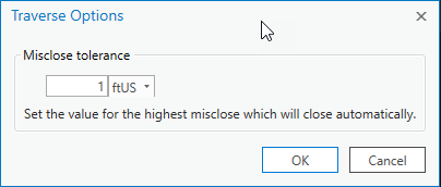
I think that what you may be seeing is that the Pro Traverse is not automatically adjusting the geometry because it is outside the test closure tolerance. You can set this value higher in the traverse options:


-Tim
- Mark as New
- Bookmark
- Subscribe
- Mute
- Subscribe to RSS Feed
- Permalink
Hi Drew,
My first thought is to check the spatial reference of the Data Frame in ArcMap vs the Map in ArcGIS Pro. No doubt since you are COGOing, you've already checked, but just wanted to confirm that they're the same, just in case!
If that's not it, I'm not sure what else it would be, but hopefully others here have some ideas!
Good luck!
-Lauren
- Mark as New
- Bookmark
- Subscribe
- Mute
- Subscribe to RSS Feed
- Permalink
Hi Lauren,
Thanks for your response on this. Both are using the same spatial reference. Good thought though. I will add that I have used ArcPro to COGO many parcels without issue. Lines up with COGO from ArcMap. There is something wrong with this one though.
- Mark as New
- Bookmark
- Subscribe
- Mute
- Subscribe to RSS Feed
- Permalink
Hi Drew, I've tested your COGO values in ArcMap, and I'm seeing a closure of 2.176 feet - this is the same as the Misclose Distance that the traverse tool in Pro gives:
Also, in your above graphic, there are also Residual values that indicate that this misclosure is getting adusted out. For example, the first course in the ArcMap COGO traverse is showing a residual value of 0.556 feet. This is the amount that this particular line was adjusted to account for the Misclosure.
I think that what you may be seeing is that the Pro Traverse is not automatically adjusting the geometry because it is outside the test closure tolerance. You can set this value higher in the traverse options:


-Tim
- Mark as New
- Bookmark
- Subscribe
- Mute
- Subscribe to RSS Feed
- Permalink
Hi Tim,
Thank you for your response. I see now that I was misunderstanding ArcPros "Misclose Distance" and "Residual Value" in ArcMap. "Misclose Distance" is measuring the distance from the "Start Location" to the "Closing Location" whereas the "Residual Values" in ArcMap are showing how each lines bearings and distances were adjusted in order to close the polygon (Please correct me if I am getting any of this wrong!).
Now my question would be how can I pull up the residual values in ArcPro? The only option I am seeing in traverse options is to adjust the misclose tolerance. I am asking because my current workflow uses the "residual values" in ArcMap to determine the polygons accuracy so it is important that I have these values available in ArcPro as well.
Thanks again.
- Mark as New
- Bookmark
- Subscribe
- Mute
- Subscribe to RSS Feed
- Permalink
Drew,
I've created an idea post to have this data included in ArcPro please feel free to go over and support it. ESRI uses these as a measure for what the users want so the more support the better.
I also heavily rely on those residual values.