Turn on suggestions
Auto-suggest helps you quickly narrow down your search results by suggesting possible matches as you type.
Cancel
- Home
- :
- All Communities
- :
- Developers
- :
- Native Maps SDKs
- :
- Java Maps SDK Questions
- :
- Advanced Symbology 2525C questions
Options
- Subscribe to RSS Feed
- Mark Topic as New
- Mark Topic as Read
- Float this Topic for Current User
- Bookmark
- Subscribe
- Mute
- Printer Friendly Page
07-01-2013
07:53 AM
- Mark as New
- Bookmark
- Subscribe
- Mute
- Subscribe to RSS Feed
- Permalink
In case some of you have already all answers ready 🙂 (Mark or Carlos maybe !)
I'm starting to learn MIL-STD-2525C standard (with ArcGIS Runtime for Java)... analyzing Java sample codes and Vehicle Commander application source... but I don't have enough Defense knownledge to understand how to use completly ArcGIS Runtime possibilities...
Could you please provide some simple code or answers to this :
Thanks in advance for any help
I'm starting to learn MIL-STD-2525C standard (with ArcGIS Runtime for Java)... analyzing Java sample codes and Vehicle Commander application source... but I don't have enough Defense knownledge to understand how to use completly ArcGIS Runtime possibilities...
Could you please provide some simple code or answers to this :
- I can't get any label drawn with my symbol... how to do that ?
- I'm not sure to fully understand what is the difference between a Position report and Spot report...
- How can I send message to indicate the "operationnal condition" (fully capable -> damage)
- How can I specify Echelon (11th & 12th caracters of SIC code ?) or other "modifier" indicators ?
- when playing with sample code, It seems that lots of Symbols don't display on map (for example "Assault Position F" : GFGPOAA---****X) or are displayed with "unknown" (for example all "Joker" or "Faker" symbols...). Is it normal ?
- I even got an error for « Station ASW Ship H » : Warning: SHSPA----***** : SIDC does not contain 15 characters
Thanks in advance for any help
Solved! Go to Solution.
1 Solution
Accepted Solutions
07-03-2013
04:48 AM
- Mark as New
- Bookmark
- Subscribe
- Mute
- Subscribe to RSS Feed
- Permalink
I'm starting to learn MIL-STD-2525C standard (with ArcGIS Runtime for Java)... analyzing Java sample codes and Vehicle Commander application source... but I don't have enough Defense knownledge to understand how to use completly ArcGIS Runtime possibilities...
Welcome to the club!:o The vehicle commander is a good startup for understanding how advanced symbology should be implemented on an app, but it's not an all-inclusive-all-implementations solution of what standards of military symbology is all about.
I can't get any label drawn with my symbol... how to do that ?
Runtime, as of 10.1.1, have implemented only three types of adornments or labels: "Quantity", "UniqueDesignation" and "AdditionalInformation". You will find that these labels are placed on the symbol depended upon its coding scheme. The best and simplest example I've found on how to create a symbol with these labels is located here. Before you say "Wait ... this is from the android API!", note that the Java API, as most others, derived from the Android API conceptually (it was their first). There are some known issues on labels I've posted elsewhere on this forum and some workarounds Mark have provided until the API is fixed.
I'm not sure to fully understand what is the difference between a Position report and Spot report...
Militarily speaking, there is a difference (self-reporting friendly entities vs. entities observed and reported by these self-reporting entities), but I don't think there is a difference as far how symbols are plotted on the graphic layers controlled by the message group layer, other than that it wants to be able to create separate graphic layers for each. If there is a difference as far as adornments are concerned, Ive' not noticed it.
How can I specify Echelon (11th & 12th caracters of SIC code ?) or other "modifier" indicators ?
I'm not so sure what you're asking here other than doing it, but the manual William pointed you to has appendices for each coding scheme of symbols. Each set contains a table for modifiers for size and/or mobility. So, the two-character modifier code depends on the coding scheme.
when playing with sample code, It seems that lots of Symbols don't display on map (for example "Assault Position F" : GFGPOAA---****X) or are displayed with "unknown" (for example all "Joker" or "Faker" symbols...). Is it normal ?
That first character (coding scheme/appendix on the manual) tells me that this symbol may require more than one "control point" in the string in order for the symbol to plot. The Esri sample does not implement that. The android link does show how to "string out" the set of X's and Y's. I've found this to be true even if the symbol appears as a single icon sometimes. You'll have to test that out to see which is which because they're more than 1,400 symbols in the dictionary (last I counted).
I even got an error for « Station ASW Ship H » : Warning: SHSPA----***** : SIDC does not contain 15 characters
If you haven't figured this one out yet, you only have 14 characters on the "SIC" property. Also, keep in mind that the dictionary does not care if you give it "*" where a character is not required but may be filled or "X" on must-not-fill characters for symbols with certain coding schemes. I simply use "-" across the board where I don't have a character to place there. The "pattern" is for users to understand how to use it.
7 Replies
07-01-2013
10:17 AM
- Mark as New
- Bookmark
- Subscribe
- Mute
- Subscribe to RSS Feed
- Permalink
I may be able to help you out with a couple of these.
- There are multiple labels you can put on symbols. I believe one of them is with the AdditionalInformation field on the Esri Message.
- This is bad nomenclature on ERIS's part. The key difference though is Position Report is typically used for friendly forces that will be report there locations. Spots reports are other observed entities (usually hostile though they don't have to be) or actions that systems report. From a functional standpoint I believe this was split up so that the subsets could easily be toggled on or off because they end up on different layers.
- The operational condition is the 4th character in the symbol code. Present -P, Anticipated Planned -A, Present Fully Capable - C, Present Damaged -D, Present Destroyed - X, Present Full to Capacity F.
- I'm not totally sure what you're after on the Echelon. The 11th / 12th character slots are for size / mobility. Echelon is included in this. I can't really list all of them because there are 100+ options.
- I'm not sure, sorry don't have time to look into this at the moment.
- This symbol code only has 14 characters.
07-02-2013
07:12 AM
- Mark as New
- Bookmark
- Subscribe
- Mute
- Subscribe to RSS Feed
- Permalink
Thanks again for your fast reply.
Do you have any sample code for this ? I don't understand what I'm doing wrong.... if I add the line :
message.setProperty("AdditionalInformation", myStringLabelHere);
there is no label at all on my map... but it's working for the sample MessageProcessorApp which load an XML file with similar Property names.
Ok.
Thanks.
It took me a while to fully get the Mil2525C specifications according to the coding scheme... SIDC 15 characters meaning and all modifiers options.
However, It would be nice to get an ESRI documentation, as some implementation of the Symbol Dictionnary may need some explanation (why "assumed friend" symbols are identical to "friend" ? same question for "suspect" and "hostile"... no dashed line for "pending" symbols...)
I guess I was not using Filters correctly as I tried to use SIDC with point, when it's applicable for line or area...
Right... but it's coming from the Dictionnary, so should it not be on 15 characters ?
Except for labelling, I guess it's working fine for now.
- There are multiple labels you can put on symbols. I believe one of them is with the AdditionalInformation field on the Esri Message.
Do you have any sample code for this ? I don't understand what I'm doing wrong.... if I add the line :
message.setProperty("AdditionalInformation", myStringLabelHere);
there is no label at all on my map... but it's working for the sample MessageProcessorApp which load an XML file with similar Property names.
- This is bad nomenclature on ESRI's part. The key difference though is Position Report is typically used for friendly forces that will be report there locations. Spots reports are other observed entities (usually hostile though they don't have to be) or actions that systems report. From a functional standpoint I believe this was split up so that the subsets could easily be toggled on or off because they end up on different layers.
Ok.
- The operational condition is the 4th character in the symbol code. Present -P, Anticipated Planned -A, Present Fully Capable - C, Present Damaged -D, Present Destroyed - X, Present Full to Capacity F.
- I'm not totally sure what you're after on the Echelon. The 11th / 12th character slots are for size / mobility. Echelon is included in this. I can't really list all of them because there are 100+ options.
Thanks.
It took me a while to fully get the Mil2525C specifications according to the coding scheme... SIDC 15 characters meaning and all modifiers options.
However, It would be nice to get an ESRI documentation, as some implementation of the Symbol Dictionnary may need some explanation (why "assumed friend" symbols are identical to "friend" ? same question for "suspect" and "hostile"... no dashed line for "pending" symbols...)
- I'm not sure, sorry don't have time to look into this at the moment.
I guess I was not using Filters correctly as I tried to use SIDC with point, when it's applicable for line or area...
- This symbol code only has 14 characters.
Right... but it's coming from the Dictionnary, so should it not be on 15 characters ?
Except for labelling, I guess it's working fine for now.
07-02-2013
10:20 AM
- Mark as New
- Bookmark
- Subscribe
- Mute
- Subscribe to RSS Feed
- Permalink
In case you don't have it: 2525C
Also another label field is UniqueDesignation. Unfortunately I see no place where constants or enumerations are defined to actually track these things down. If you manage to get a symbol with labels you can probably get the SymbolProperties and then get the values from there.
Also another label field is UniqueDesignation. Unfortunately I see no place where constants or enumerations are defined to actually track these things down. If you manage to get a symbol with labels you can probably get the SymbolProperties and then get the values from there.
07-03-2013
01:10 AM
- Mark as New
- Bookmark
- Subscribe
- Mute
- Subscribe to RSS Feed
- Permalink
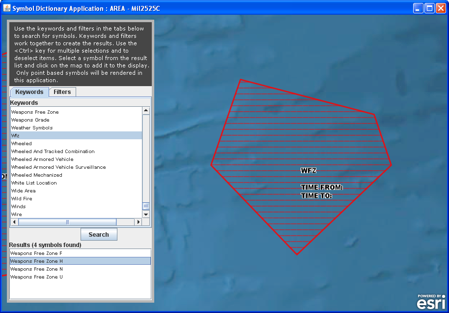
Yes, it's the only documentation I have... but still I'm missing info.
For example, some additional information are specific and I don't know how to set these values.
my illustration is an Area symbol "Weapons Free Zone H" and at predefined scale, it display labels on the polygon. in this case it's "Time From" and "Time To".
[ATTACH=CONFIG]25681[/ATTACH]
So in the MIL2525 documentation - page 496 - the template indicates that there are 3 parameters "T", "W" and "W1"... but how can I set values for these and send it with the message so time from/to can be displayed ??
- page 41 - (5.5.2.6), there's an explanation for Date-Time group (for my "W" and "W1" info), with short format DDHHMMZMONYY, but what Message Property Name can I use ?
07-03-2013
04:48 AM
- Mark as New
- Bookmark
- Subscribe
- Mute
- Subscribe to RSS Feed
- Permalink
I'm starting to learn MIL-STD-2525C standard (with ArcGIS Runtime for Java)... analyzing Java sample codes and Vehicle Commander application source... but I don't have enough Defense knownledge to understand how to use completly ArcGIS Runtime possibilities...
Welcome to the club!:o The vehicle commander is a good startup for understanding how advanced symbology should be implemented on an app, but it's not an all-inclusive-all-implementations solution of what standards of military symbology is all about.
I can't get any label drawn with my symbol... how to do that ?
Runtime, as of 10.1.1, have implemented only three types of adornments or labels: "Quantity", "UniqueDesignation" and "AdditionalInformation". You will find that these labels are placed on the symbol depended upon its coding scheme. The best and simplest example I've found on how to create a symbol with these labels is located here. Before you say "Wait ... this is from the android API!", note that the Java API, as most others, derived from the Android API conceptually (it was their first). There are some known issues on labels I've posted elsewhere on this forum and some workarounds Mark have provided until the API is fixed.
I'm not sure to fully understand what is the difference between a Position report and Spot report...
Militarily speaking, there is a difference (self-reporting friendly entities vs. entities observed and reported by these self-reporting entities), but I don't think there is a difference as far how symbols are plotted on the graphic layers controlled by the message group layer, other than that it wants to be able to create separate graphic layers for each. If there is a difference as far as adornments are concerned, Ive' not noticed it.
How can I specify Echelon (11th & 12th caracters of SIC code ?) or other "modifier" indicators ?
I'm not so sure what you're asking here other than doing it, but the manual William pointed you to has appendices for each coding scheme of symbols. Each set contains a table for modifiers for size and/or mobility. So, the two-character modifier code depends on the coding scheme.
when playing with sample code, It seems that lots of Symbols don't display on map (for example "Assault Position F" : GFGPOAA---****X) or are displayed with "unknown" (for example all "Joker" or "Faker" symbols...). Is it normal ?
That first character (coding scheme/appendix on the manual) tells me that this symbol may require more than one "control point" in the string in order for the symbol to plot. The Esri sample does not implement that. The android link does show how to "string out" the set of X's and Y's. I've found this to be true even if the symbol appears as a single icon sometimes. You'll have to test that out to see which is which because they're more than 1,400 symbols in the dictionary (last I counted).
I even got an error for « Station ASW Ship H » : Warning: SHSPA----***** : SIDC does not contain 15 characters
If you haven't figured this one out yet, you only have 14 characters on the "SIC" property. Also, keep in mind that the dictionary does not care if you give it "*" where a character is not required but may be filled or "X" on must-not-fill characters for symbols with certain coding schemes. I simply use "-" across the board where I don't have a character to place there. The "pattern" is for users to understand how to use it.
07-03-2013
06:55 AM
- Mark as New
- Bookmark
- Subscribe
- Mute
- Subscribe to RSS Feed
- Permalink
It would be nice to get an ESRI documentation, as some implementation of the Symbol Dictionnary may need some explanation (why "assumed friend" symbols are identical to "friend" ? same question for "suspect" and "hostile"... no dashed line for "pending" symbols...)
I feel your pain. I posted this and other questions, and mentioned the 2525C's "requirements" on several posts without reply or, in some cases, a hope that it may be added in the future.
07-05-2013
06:20 AM
- Mark as New
- Bookmark
- Subscribe
- Mute
- Subscribe to RSS Feed
- Permalink
Thanks Carlos for these additional information... thanks to your inputs and more advanced tests and understnading of the Vehicle Commander application, I'm now able to do what I want.
For labels, I didn't understand the min/maxScale issue from Json type file.
Same thing for ChemLight, it took me a while to understand that we can maange our own file type, as it is done on the application (afmchemlight, etc.)
I guess more questions will come with advanced development, but I really hope ESRI will provide more documentation in the future (maybe for 10.2 this summer ?), and maybe a dedicated Training course 🙂