- Home
- :
- All Communities
- :
- Products
- :
- Oriented Imagery
- :
- Oriented Imagery Classic
- :
- What metadata is needed to use measurement tools i...
- Subscribe to RSS Feed
- Mark Topic as New
- Mark Topic as Read
- Float this Topic for Current User
- Bookmark
- Subscribe
- Mute
- Printer Friendly Page
What metadata is needed to use measurement tools in Oriented Imagery Viewer?
- Mark as New
- Bookmark
- Subscribe
- Mute
- Subscribe to RSS Feed
- Permalink
- Report Inappropriate Content
Hi all,
I've been trying to figure what metadata is needed to be able to use measurement tools in Oriented Imagery Viewer. I've created an Oriented Imagery catalog from aerial oblique imagery service (https://sampleserver6.arcgisonline.com/arcgis/rest/services/Oblique/WU_Oblique/ImageServer) . Looking at the resulting exposure points - they have CamOri field with detailed camera orientation. I've also used DEM service when I created this catalog. But I'm still unable to use measurement tools with this oriented imagery catalog:

This is the content of the oic:
{"type": "OIC", "version": "2.1", "properties": {"Name": "test8", "Description": "test", "Tags": "OrientedImagery", "ServiceURL": "https://services6.arcgis.com/YtqGNFEdrYd1pjuW/arcgis/rest/services/test8_ExposurePoints/FeatureServer/1", "OverviewURL": "https://tiles.arcgis.com/tiles/YtqGNFEdrYd1pjuW/arcgis/rest/services/test8_CoverageMap/VectorTileServer", "DefaultAttributes": {"CamHeading": "", "CamPitch": "", "CamRoll": "0", "HFOV": "", "VFOV": "", "AvgHtAG": "", "FarDist": "", "NearDist": "", "OIType": "T", "SortOrder": "", "CamOffset": "", "Accuracy": "", "ImgPyramids": "", "DepthImg": "", "ExternalViewer": "", "ImgRot": "", "ImageryType": "Aerial Oblique Camera"}, "About": "", "ImageField": "", "ImagePrefix": "", "VideoPrefix": "", "DepthImagePrefix": "", "SourceImagePrefix": "", "MaxDistance": "", "DEMPrefix": "I||https://elevation3d.arcgis.com/arcgis/rest/services/WorldElevation3D/Terrain3D/ImageServer", "Credentials": {"Username": "", "Password": ""}, "Variables": {}, "Filters": {}, "Copyright": {"text": "test", "url": ""}, "PointsSource": "D:\\Temp\\oblique\\oblique\\orient_test\\test8.gdb\\test8_ExposurePoints", "CoverageSource": "D:\\Temp\\oblique\\oblique\\orient_test\\test8.gdb\\test8_CoverageMap"}}
What data is needed for the measurement functions in OI Viewer to be available?
Thank you,
Tadas
Solved! Go to Solution.
Accepted Solutions
- Mark as New
- Bookmark
- Subscribe
- Mute
- Subscribe to RSS Feed
- Permalink
- Report Inappropriate Content
Hi Tadas,
To activate measurement tool in the viewer, you will need to define the Accuracy field in the Exposure Points feature service.
You can get more detail about the accuracy parameter and how it can be defined from this documentation.
Documentation Link - oriented-imagery/OrientedImageryCatalog_Schema.pdf at master · Esri/oriented-imagery · GitHub
Also, here is the snippet

You can put dummy value for Accuracy field - 0.5,0.5,1,1,1,1,1,1 to quickly test the measurement capability.
You can also define the Accuracy in OIC (See below)
{"type": "OIC", "version": "2.1", "properties": {"Name": "test8", "Description": "test", "Tags": "OrientedImagery", "ServiceURL": "https://services6.arcgis.com/YtqGNFEdrYd1pjuW/arcgis/rest/services/test8_ExposurePoints/FeatureServe...", "OverviewURL": "https://tiles.arcgis.com/tiles/YtqGNFEdrYd1pjuW/arcgis/rest/services/test8_CoverageMap/VectorTileSer...", "DefaultAttributes": {"CamHeading": "", "CamPitch": "", "CamRoll": "0", "HFOV": "", "VFOV": "", "AvgHtAG": "", "FarDist": "", "NearDist": "", "OIType": "T", "SortOrder": "", "CamOffset": "", "Accuracy": "0.5,0.5,1,1,1,1,1,1", "ImgPyramids": "", "DepthImg": "", "ExternalViewer": "", "ImgRot": "", "ImageryType": "Aerial Oblique Camera"}, "About": "", "ImageField": "", "ImagePrefix": "", "VideoPrefix": "", "DepthImagePrefix": "", "SourceImagePrefix": "", "MaxDistance": "", "DEMPrefix": "I||https://elevation3d.arcgis.com/arcgis/rest/services/WorldElevation3D/Terrain3D/ImageServer", "Credentials": {"Username": "", "Password": ""}, "Variables": {}, "Filters": {}, "Copyright": {"text": "test", "url": ""}, "PointsSource": "D:\\Temp\\oblique\\oblique\\orient_test\\test8.gdb\\test8_ExposurePoints", "CoverageSource": "D:\\Temp\\oblique\\oblique\\orient_test\\test8.gdb\\test8_CoverageMap"}}
Thank You.
Kushagra Patel
- Mark as New
- Bookmark
- Subscribe
- Mute
- Subscribe to RSS Feed
- Permalink
- Report Inappropriate Content
Do you get the solution about this?
- Mark as New
- Bookmark
- Subscribe
- Mute
- Subscribe to RSS Feed
- Permalink
- Report Inappropriate Content
Hi Tadas,
To activate measurement tool in the viewer, you will need to define the Accuracy field in the Exposure Points feature service.
You can get more detail about the accuracy parameter and how it can be defined from this documentation.
Documentation Link - oriented-imagery/OrientedImageryCatalog_Schema.pdf at master · Esri/oriented-imagery · GitHub
Also, here is the snippet
You can put dummy value for Accuracy field - 0.5,0.5,1,1,1,1,1,1 to quickly test the measurement capability.
You can also define the Accuracy in OIC (See below)
{"type": "OIC", "version": "2.1", "properties": {"Name": "test8", "Description": "test", "Tags": "OrientedImagery", "ServiceURL": "https://services6.arcgis.com/YtqGNFEdrYd1pjuW/arcgis/rest/services/test8_ExposurePoints/FeatureServe...", "OverviewURL": "https://tiles.arcgis.com/tiles/YtqGNFEdrYd1pjuW/arcgis/rest/services/test8_CoverageMap/VectorTileSer...", "DefaultAttributes": {"CamHeading": "", "CamPitch": "", "CamRoll": "0", "HFOV": "", "VFOV": "", "AvgHtAG": "", "FarDist": "", "NearDist": "", "OIType": "T", "SortOrder": "", "CamOffset": "", "Accuracy": "0.5,0.5,1,1,1,1,1,1", "ImgPyramids": "", "DepthImg": "", "ExternalViewer": "", "ImgRot": "", "ImageryType": "Aerial Oblique Camera"}, "About": "", "ImageField": "", "ImagePrefix": "", "VideoPrefix": "", "DepthImagePrefix": "", "SourceImagePrefix": "", "MaxDistance": "", "DEMPrefix": "I||https://elevation3d.arcgis.com/arcgis/rest/services/WorldElevation3D/Terrain3D/ImageServer", "Credentials": {"Username": "", "Password": ""}, "Variables": {}, "Filters": {}, "Copyright": {"text": "test", "url": ""}, "PointsSource": "D:\\Temp\\oblique\\oblique\\orient_test\\test8.gdb\\test8_ExposurePoints", "CoverageSource": "D:\\Temp\\oblique\\oblique\\orient_test\\test8.gdb\\test8_CoverageMap"}}
Thank You.
Kushagra Patel
- Mark as New
- Bookmark
- Subscribe
- Mute
- Subscribe to RSS Feed
- Permalink
- Report Inappropriate Content
Will I modify Accuracy using a property tool without recreate features
coverage, coverage map and publish?
Le lun. 28 sept. 2020 à 21:30, Kushagra Patel <geonet@esri.com> a écrit :
GeoNet, The Esri Community | GIS and Geospatial Professional Community
<https://community.esri.com/?et=watches.email.thread>
Re: What metadata is needed to use measurement tools in Oriented Imagery
Viewer?
reply from Kushagra Patel
<https://community.esri.com/people/Kushagra_Patel-esristaff?et=watches.email.thread>
in Imagery and Remote Sensing - View the full discussion
<https://community.esri.com/message/956057-re-what-metadata-is-needed-to-use-measurement-tools-in-oriented-imagery-viewer?commentID=956057&et=watches.email.thread#comment-956057>
- Mark as New
- Bookmark
- Subscribe
- Mute
- Subscribe to RSS Feed
- Permalink
- Report Inappropriate Content
Yes. Enter the Accuracy field value here.
- Mark as New
- Bookmark
- Subscribe
- Mute
- Subscribe to RSS Feed
- Permalink
- Report Inappropriate Content
After that, will I just re-publish the catalog or re-run Feature coverage
and coverage map?
Le mar. 29 sept. 2020 à 16:47, Kushagra Patel <geonet@esri.com> a écrit :
GeoNet, The Esri Community | GIS and Geospatial Professional Community
<https://community.esri.com/?et=watches.email.thread>
Re: What metadata is needed to use measurement tools in Oriented Imagery
Viewer?
reply from Kushagra Patel
<https://community.esri.com/people/Kushagra_Patel-esristaff?et=watches.email.thread>
in Imagery and Remote Sensing - View the full discussion
<https://community.esri.com/message/956208-re-what-metadata-is-needed-to-use-measurement-tools-in-oriented-imagery-viewer?commentID=956208&et=watches.email.thread#comment-956208>
- Mark as New
- Bookmark
- Subscribe
- Mute
- Subscribe to RSS Feed
- Permalink
- Report Inappropriate Content
Should I put values like this?
Le mar. 29 sept. 2020 à 09:57, Soukaina MENJEL <soukaina.menjel@gmail.com>
a écrit :
Will I modify Accuracy using a property tool without recreate features
coverage, coverage map and publish?
Le lun. 28 sept. 2020 à 21:30, Kushagra Patel <geonet@esri.com> a écrit :
>> GeoNet, The Esri Community | GIS and Geospatial Professional Community
>> <https://community.esri.com/?et=watches.email.thread>
>> Re: What metadata is needed to use measurement tools in Oriented Imagery
>> Viewer?
>>
>> reply from Kushagra Patel
>> <https://community.esri.com/people/Kushagra_Patel-esristaff?et=watches.email.thread>
>> in Imagery and Remote Sensing - View the full discussion
>> <https://community.esri.com/message/956057-re-what-metadata-is-needed-to-use-measurement-tools-in-oriented-imagery-viewer?commentID=956057&et=watches.email.thread#comment-956057>
>>
- Mark as New
- Bookmark
- Subscribe
- Mute
- Subscribe to RSS Feed
- Permalink
- Report Inappropriate Content
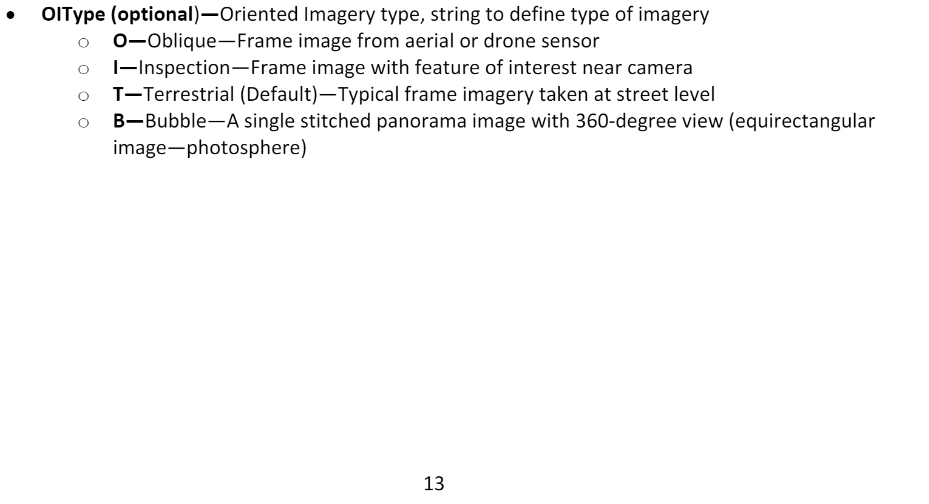
Another question, I see that you make OIType: T, and when I see my
properties I found that it was a B Type.
What's the types of OIC? and is it necessary to make the type T?
Le lun. 28 sept. 2020 à 21:30, Kushagra Patel <geonet@esri.com> a écrit :
GeoNet, The Esri Community | GIS and Geospatial Professional Community
<https://community.esri.com/?et=watches.email.thread>
Re: What metadata is needed to use measurement tools in Oriented Imagery
Viewer?
reply from Kushagra Patel
<https://community.esri.com/people/Kushagra_Patel-esristaff?et=watches.email.thread>
in Imagery and Remote Sensing - View the full discussion
<https://community.esri.com/message/956057-re-what-metadata-is-needed-to-use-measurement-tools-in-oriented-imagery-viewer?commentID=956057&et=watches.email.thread#comment-956057>
- Mark as New
- Bookmark
- Subscribe
- Mute
- Subscribe to RSS Feed
- Permalink
- Report Inappropriate Content
No. It depends on what type of image you have. It is defined in this document - oriented-imagery/OrientedImageryCatalog_Schema.pdf at master · Esri/oriented-imagery · GitHub
- Mark as New
- Bookmark
- Subscribe
- Mute
- Subscribe to RSS Feed
- Permalink
- Report Inappropriate Content