- Home
- :
- All Communities
- :
- Products
- :
- ArcGIS Drone2Map
- :
- ArcGIS Drone2Map Questions
- :
- Re: Drone2Map 3D: What am I looking at?
- Subscribe to RSS Feed
- Mark Topic as New
- Mark Topic as Read
- Float this Topic for Current User
- Bookmark
- Subscribe
- Mute
- Printer Friendly Page
Drone2Map 3D: What am I looking at?
- Mark as New
- Bookmark
- Subscribe
- Mute
- Subscribe to RSS Feed
- Permalink
- Report Inappropriate Content
I ran my first 3D analysis on a Drone2Map project, and I can't figure out what I am looking at.
In Drone2Map, why does the 3D Mesh appear to be about 100m in the air above the background imagery surface? https://www.dropbox.com/s/vplvwlldruuoft3/Screenshot%202018-12-14%2011.56.13.png?dl=0 Why are some of the drone photo blue dots and the connecting flight lines seem to be at the surface of the base surface? Are these the photos that just contained only water so they couldn't be placed? Or are these the photos that couldn't be tied to the ground control points?
I tried looking at my D2M project in Pro. Dropbox - Screenshot 2018-12-14 12.20.53.png https://www.dropbox.com/s/387p0xemoyb7r9i/Screenshot%202018-12-14%2012.20.53.png?dl=0
Same questions about the photo locations, and the flight paths. But why are the two elevation surfaces not showing up? One was the GISPro default World Elevation 3D, while Topovector.GIS.midcoldem10m is my own 10m DEM in this area. The scene stuff in Pro is new to me.
The 2D runs on this drone flight worked out pretty good in Drone2Map. But this 3d stuff has me puzzled.
- Mark as New
- Bookmark
- Subscribe
- Mute
- Subscribe to RSS Feed
- Permalink
- Report Inappropriate Content
What is the source of your GCPs? Offhand I cant think of any reasons why your drone images are placed at different heights. Did you perhaps try adjusting the image properties? Image Properties > Image Options > Adjust Image Altitudes.
It would be useful to know whether the altitude values for each image also show this abrupt change in altitude? This would be easy to see from the image properties pane as in below image. Therefore pointing to whether the problem lies with the recorded altitude metadata values or the Drone2Map/GCP processes.

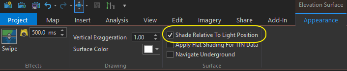
What makes you think that the two elevation surfaces are not showing up? They are invisible as they are only used to adjust the height of the 2D layer pixels but you can see them if you turn on Shade Relative To Light Position on the Elevation Surface Appearance tab. Or you could try draping over any other raster surface.
Your situation is certainly unusual and I don't think I have any answers but it will be useful to better understand what is going on.
- Mark as New
- Bookmark
- Subscribe
- Mute
- Subscribe to RSS Feed
- Permalink
- Report Inappropriate Content
I finally got the mesh created at the correct altitude, but I don't understand why this worked. ESRI tech support advised me "I took a closer look at the EXIF information associated with the images and believe I found the issue. The issue we are running into isn't the vertical coordinate system we are setting but the necessary altitude adjustment we need to set to the images. The absolute altitude of the images is roughly 38.24m, while the relative altitude is 83.90m. I subtracted the difference of the two altitudes(45.66m) and used that value to adjust the altitude of the flight. Using this method I was able to successfully generate the SLPK at the correct elevation."
"I have been testing with the vertical references set to No Conversion instead of EGM 96, so changing the vertical reference to "No Conversion" and the the flight altitude to 45.66m should resolve the issue for you based on my output.
"The absolute altitude for the images captured seems to be the GPS altitude in meters Above Sea Level according to the output of the EXIF tool, however most EXIF information and the way it is captured is particular to the Drone that is used during the flight. "
So I ran my job at flight altitude 45.66m and got a 3D mesh that fits the terrain well. https://www.dropbox.com/s/hh1y5r8woll42tl/3dwithelevfixed.PNG?dl=0