- Home
- :
- All Communities
- :
- Industries
- :
- Imagery and Remote Sensing Insights (IRIS) COP
- :
- Imagery Questions
- :
- Calculating NDVI from Landsat 8 USGS Tiles
- Subscribe to RSS Feed
- Mark Topic as New
- Mark Topic as Read
- Float this Topic for Current User
- Bookmark
- Subscribe
- Mute
- Printer Friendly Page
- Mark as New
- Bookmark
- Subscribe
- Mute
- Subscribe to RSS Feed
- Permalink
- Report Inappropriate Content
I'm busy writing a Python module to calculate the NDVI (Normalized Difference Vegetation Index) based on the following post: Using Python to calculate NDVI with multiband imagery. According to the USGS background data on Landsat 8 Product, the tiles are provided as Digitial Numbers 16-bit unsigned integer format. The current examples (tutorials and reference material) that I've found to calculate NDVI use Landsat 5 + 7 which is stored as 8-bit unsigned integer format. Can I still use the same formula to calculate NDVI for Landsat 8 that is now stored as 16-bit unsigned integer format. The formula that I'm using is found in: Making Spatial Decisions Using GIS and Remote Sensing: A Workbook
NDVI = (IR-R)/(IR+R)
ArcGIS: USGS Landsat 8 GeoTIFF (Bands 4 + 5)
ArcGIS: scale range of Landsat 8 Bands 4 + 5

USGS: Using the USGS Landsat 8 Product
USGS EarthExplorer: Landsat 8 Dataset Selection

USGS EarthExplorer: Landsat 8 Download Options
Solved! Go to Solution.
Accepted Solutions
- Mark as New
- Bookmark
- Subscribe
- Mute
- Subscribe to RSS Feed
- Permalink
- Report Inappropriate Content
Peter, if you are checking the script for whether it is working, run it manually and compare results.
Your only other alternative is to generate 'images' that have a known patterns of values from which you could calculate NDVI. This can be done in numpy
ir = [[1, 64, 128], [128, 192, 255], [255, 128, 1]] # I have left 0's out for now
r = np.swapaxes(ir, 1, 0)
r
array([[ 1, 128, 255],
[ 64, 192, 128],
[128, 255, 1]])
np.divide(ir - r, ir + r) # or whatever
array([[ 0. , -0.33333333, -0.33159269],
[ 0.33333333, 0. , 0.33159269],
[ 0.33159269, -0.33159269, 0. ]])Obviously, the only catch is to use masked arrays to mask 0 values to prevent division by zero errors. (hope I got stuff right... scale the input ranges to suit)
- Mark as New
- Bookmark
- Subscribe
- Mute
- Subscribe to RSS Feed
- Permalink
- Report Inappropriate Content
not sure I follow... 16 bit isn't 0-255 https://en.wikipedia.org/wiki/16-bit 8-bit is https://en.wikipedia.org/wiki/8-bit
- Mark as New
- Bookmark
- Subscribe
- Mute
- Subscribe to RSS Feed
- Permalink
- Report Inappropriate Content
Hi Dan
I found the following on ResearchGate:

Based on the following I presume that I should be able to calculate the NDVI using same formula, its just that the Landsat 8 is being stored in 16-bit and not 8-bit.
- Mark as New
- Bookmark
- Subscribe
- Mute
- Subscribe to RSS Feed
- Permalink
- Report Inappropriate Content
Peter
- Agreed with Dan, you should be using the full 16 bit range, not scaling to 8 bit. The simple difference ratio equation you show
NDVI = (IR-R)/(IR+R)
IS the equation for NDVI. It does not have any requirement to be 8 bit (0-255) so you should use the full range of values available in the data. - Second, unless this is purely an exercise for you to learn more Python, why start from scratch? ArcGIS can immediately calculate NDVI for you - let us know which version you have (ArcGIS Pro 2.0.1? ArcMap?) and we can advise for how to do it. Note the NDVI tools within ArcGIS may automatically apply a color ramp, but you'll presumably want the "scientific" version which outputs the raw floating point values.
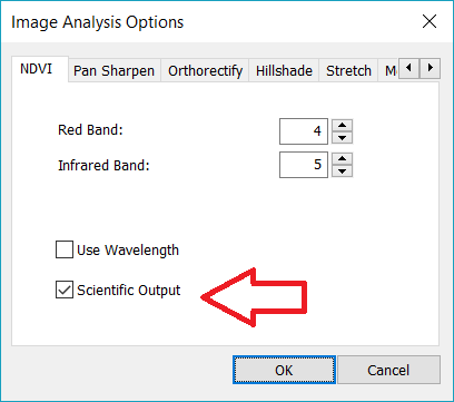
- NOTE - this will give you pixel values from -1.0 to +1.0, and you'll presumably need to rescale/convert those for VIEWING the data - but if you're attempting any quantitative analysis, you'll want to do that work with the floating point values for best accuracy
- Mark as New
- Bookmark
- Subscribe
- Mute
- Subscribe to RSS Feed
- Permalink
- Report Inappropriate Content
Hi Cody
Thanks for the response. I'd like to determine the NDVI for the dry and wet season for my study area and then determine the difference between the two. I'm currently still using ArcGIS 10.3.1, unfortunately no ArcGIS Pro. The link that I provided in my initial post is a blog post by ESRI Australia: Using Python to calculate NDVI with multiband imagery, that has a Python script for determing the NDVI. If you are able to assist in the approach I need to following once I've determined the NDVI for say (i.e. 2017 Feb (Wet) and 2017 Oct (Dry)) ,how I can show the difference in NDVI between the wet and dry season. I'd like to be able to code the following in Python as its part of a larger water project that I'm busy with.
- Mark as New
- Bookmark
- Subscribe
- Mute
- Subscribe to RSS Feed
- Permalink
- Report Inappropriate Content
a difference is sa.Minus
- Mark as New
- Bookmark
- Subscribe
- Mute
- Subscribe to RSS Feed
- Permalink
- Report Inappropriate Content
Hi Dan
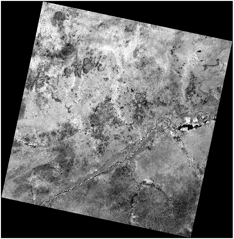
I completed writing my Python module to automatically generate NDVI rasters from Landsat 8 tiles (Downloaded from USGS EarthExplorer) with TOA Reflectance and Sun Angle correction.

NDVI: With TOA Reflectance and Sun Angle correction
NDVI: Value range (between 1 and -1)
'''
Created on 23 Sep 2017
Create NDVI Rasters
with TOA Reflectance
and Sun Angle
correction
@author: PeterW
'''
# import site-packages and modules
import re
import argparse
from pathlib import Path
import arcpy
from arcpy.sa import *
def list_landsat_tiles(landsat_dir):
"""
Create a list of Landsat 8
tiles bands 4 & 5.
"""
# Determine how to prevent nested loops - Big 0 Notation
landsat_tiles = {}
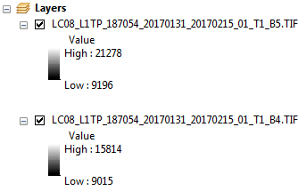
ndvi_bands = ['_B4.TIF', '_B5.TIF', '_MTL.txt']
p = Path(landsat_dir)
for directory in p.iterdir():
# add error handling to validate its subdirectories
for band in ndvi_bands:
match = '*{0}'.format(band)
landsat_tile = str(directory.glob(match).next())
landsat_name = str(directory.stem)
landsat_key = re.findall('_(\d{6})_\d{8}_(\d{8})', landsat_name)[0]
landsat_tiles.setdefault(landsat_key, []).append(landsat_tile)
return landsat_tiles
def remove_zero_values(landsat_tiles):
"""
Convert zero cell values
to NoData.
"""
arcpy.CheckOutExtension('Spatial')
for k, v in landsat_tiles.iteritems():
red_band = SetNull(v[0], v[0], 'value=0')
NIR_band = SetNull(v[1], v[1], 'value=0')
v[0] = red_band
v[1] = NIR_band
arcpy.CheckInExtension('Spatial')
def extract_reflectance_coefficients(landsat_tiles):
"""
Extract the reflectance
coefficients from metadata
txt file.
"""
for k, v in landsat_tiles.iteritems():
with open(v[2]) as mlt:
lines = mlt.read().splitlines()
reflect_mult = float(lines[187].split('=')[1])
v[2] = reflect_mult
reflect_add = float(lines[196].split('=')[1])
v.append(reflect_add)
sun_elev = float(lines[76].split('=')[1])
v.append(sun_elev)
def toa_reflectance_correction(landsat_tiles):
"""
Correct landsat 8
bands 4 & 5
for TOA reflectance
"""
arcpy.CheckOutExtension('Spatial')
for k, v in landsat_tiles.iteritems():
reflect4 = (v[2]*v[0])+v[3]
v[0] = reflect4
reflect5 = (v[2]*v[1])+v[3]
v[1] = reflect5
arcpy.CheckInExtension('Spatial')
def sun_angle_correction(landsat_tiles):
"""
Correct Landsat 8
bands 4 & 5
for sun angle
"""
arcpy.CheckOutExtension('Spatial')
for k, v in landsat_tiles.iteritems():
sun4 = (v[0]/(Sin(v[4])))
v[0] = sun4
sun5 = (v[1]/(Sin(v[4])))
v[1] = sun5
arcpy.CheckInExtension('Spatial')
def calculate_ndvi(landsat_tiles, output_dir):
"""
Generate NDVI from
preprocessed
landsat 8 bands 4 & 5
"""
arcpy.env.overwriteOutput = True
arcpy.CheckOutExtension('Spatial')
for f, v in landsat_tiles.iteritems():
NDVI_name = '_'.join(f)
arcpy.AddMessage('Processing {0}.tif NDVI'.format(NDVI_name))
Num = Float(v[1] - v[0])
Denom = Float(v[1] + v[0])
NDVI_raster = Divide(Num, Denom)
NDVI_output = '{0}\\{1}.tif'.format(output_dir, NDVI_name)
NDVI_raster.save(NDVI_output)
arcpy.CheckInExtension('Spatial')
def main(landsat_dir, output_dir):
"""
Determine NDVI for
each Landsat tile.
"""
landsat_tiles = list_landsat_tiles(landsat_dir)
remove_zero_values(landsat_tiles)
extract_reflectance_coefficients(landsat_tiles)
toa_reflectance_correction(landsat_tiles)
sun_angle_correction(landsat_tiles)
calculate_ndvi(landsat_tiles, output_dir)
if __name__ == '__main__':
parser = argparse.ArgumentParser(description='Calculate the NDVI for Landsat 8 tiles')
parser.add_argument('--landsat_dir', metavar='path', required=True,
help='Input Landsat 8 tile directory')
parser.add_argument('--output_dir', metavar='path', required=True,
help='Output NDVI directory')
args = parser.parse_args()
main(landsat_dir=args.landsat_dir,
output_dir=args.output_dir)
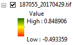
The only question that I have is that my output raster is between 1 and -1 but is not represented as 1 to -1 is that because of the actual values within my tile or is there a problem with my calculation?
- Mark as New
- Bookmark
- Subscribe
- Mute
- Subscribe to RSS Feed
- Permalink
- Report Inappropriate Content
Peter, if you are checking the script for whether it is working, run it manually and compare results.
Your only other alternative is to generate 'images' that have a known patterns of values from which you could calculate NDVI. This can be done in numpy
ir = [[1, 64, 128], [128, 192, 255], [255, 128, 1]] # I have left 0's out for now
r = np.swapaxes(ir, 1, 0)
r
array([[ 1, 128, 255],
[ 64, 192, 128],
[128, 255, 1]])
np.divide(ir - r, ir + r) # or whatever
array([[ 0. , -0.33333333, -0.33159269],
[ 0.33333333, 0. , 0.33159269],
[ 0.33159269, -0.33159269, 0. ]])Obviously, the only catch is to use masked arrays to mask 0 values to prevent division by zero errors. (hope I got stuff right... scale the input ranges to suit)
- Mark as New
- Bookmark
- Subscribe
- Mute
- Subscribe to RSS Feed
- Permalink
- Report Inappropriate Content
Thanks Dan 
- Mark as New
- Bookmark
- Subscribe
- Mute
- Subscribe to RSS Feed
- Permalink
- Report Inappropriate Content
Peter,
I have two questions:
1) I am trying to use the above code with LANDSAT data (LANDSAT 8 OLI_TIRS C1 Level-1) to calculate NDVI for a given state in US. I am getting the following error:
Runtime error
Traceback (most recent call last):
File "<string>", line 4, in <module>
ImportError: No module named pathlib.
I tried installing pathlib but i cannot install due to security reasons in my official laptop.i tried os.path but did not work too. Do not know the reason.
2). Is there a work around for the above code for using LANDSAT ARD data to calculate NDVI values.?
Any help is appreciated.