- Home
- :
- All Communities
- :
- Products
- :
- Imagery and Remote Sensing
- :
- Imagery Questions
- :
- How do you analyze two images?
- Subscribe to RSS Feed
- Mark Topic as New
- Mark Topic as Read
- Float this Topic for Current User
- Bookmark
- Subscribe
- Mute
- Printer Friendly Page
How do you analyze two images?
- Mark as New
- Bookmark
- Subscribe
- Mute
- Subscribe to RSS Feed
- Permalink
- Report Inappropriate Content
Is there an automated way to analyze two imagery layers in arcmap?
Solved! Go to Solution.
Accepted Solutions
- Mark as New
- Bookmark
- Subscribe
- Mute
- Subscribe to RSS Feed
- Permalink
- Report Inappropriate Content
It isn't going to return you anything useful. You basically have pictures, so you would just get the differences in color values.
It would take way less time to create a point file of the burn locations and tie those into a municipal lot file.
If you need the actual areas, then manually digitizing them would probably still be faster than performing a before and after image classification, cleaning the data up, doing some testing of the classification.
Human-ware is a pretty good tool, often under-rated and under-utilized
- Mark as New
- Bookmark
- Subscribe
- Mute
- Subscribe to RSS Feed
- Permalink
- Report Inappropriate Content
Are you referring to classification?
Overview of image classification—ArcGIS Pro | ArcGIS Desktop
or are they already classified and you are looking to do something with them?
- Mark as New
- Bookmark
- Subscribe
- Mute
- Subscribe to RSS Feed
- Permalink
- Report Inappropriate Content
I think they are classified. I would like to analyze one that has burn images with the other that doesn't. Whatever the best and most automated way is.
- Mark as New
- Bookmark
- Subscribe
- Mute
- Subscribe to RSS Feed
- Permalink
- Report Inappropriate Content
What do you want to analyze? You could subtract them to begin with. Explain those differences.
It isn't automated thought, you have to use the Minus tool from arctoolbox
- Mark as New
- Bookmark
- Subscribe
- Mute
- Subscribe to RSS Feed
- Permalink
- Report Inappropriate Content
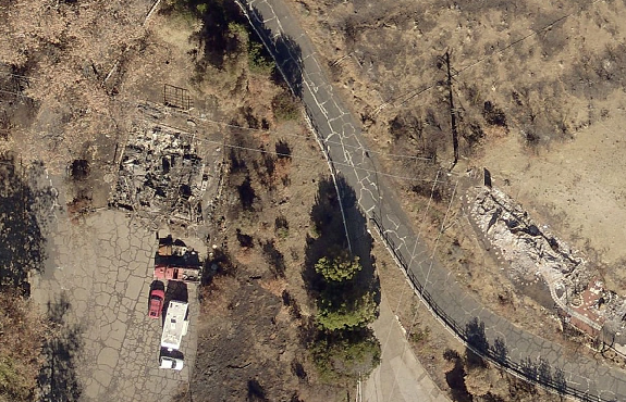

I am trying to create a vector polygon for the changes in the burned houses. Like red for the burned and green for not. I tried to use the difference button on the image analysis to show the changes in raster form. It might need some fiddling with. I then want to somehow that to vector.
- Mark as New
- Bookmark
- Subscribe
- Mute
- Subscribe to RSS Feed
- Permalink
- Report Inappropriate Content

Result of using the difference button. Not much contrast to identify the burned houses.
- Mark as New
- Bookmark
- Subscribe
- Mute
- Subscribe to RSS Feed
- Permalink
- Report Inappropriate Content
As suspected, the images aren't classified.
At this stage, I would just recommend creating a point file and mark a point for each house that was burned.
At least then, you could reference the locations to a map that has lot or subdivision plans
- Mark as New
- Bookmark
- Subscribe
- Mute
- Subscribe to RSS Feed
- Permalink
- Report Inappropriate Content
The possibilities to automate the process depend highly on the type of information you have available. If the spectral response of a burned house is different from a house that wasn't burned, you could classify both images and compare the results. It would help to have a dataset with the building footprints to limit the comparison to only houses.
Some reading here: Understanding segmentation and classification—Help | ArcGIS Desktop
If that doesn't work, there are ways to use Deep Learning to detect burned houses, but that will be pretty complex.
- Mark as New
- Bookmark
- Subscribe
- Mute
- Subscribe to RSS Feed
- Permalink
- Report Inappropriate Content
Thanks guys. There is no way to use the difference button on unclassified images in the image analysis window?
- Mark as New
- Bookmark
- Subscribe
- Mute
- Subscribe to RSS Feed
- Permalink
- Report Inappropriate Content
I don't any image classification training would accurately detect what is burned and what isn't