- Home
- :
- All Communities
- :
- Products
- :
- Imagery and Remote Sensing
- :
- Imagery Questions
- :
- Camera file for MAVIC2-ENTERPRISE-ADVANCED
- Subscribe to RSS Feed
- Mark Topic as New
- Mark Topic as Read
- Float this Topic for Current User
- Bookmark
- Subscribe
- Mute
- Printer Friendly Page
Camera file for MAVIC2-ENTERPRISE-ADVANCED
- Mark as New
- Bookmark
- Subscribe
- Mute
- Subscribe to RSS Feed
- Permalink
- Report Inappropriate Content
Seeking assistance with camera file data for a MAVIC2-ENTERPRISE-ADVANCED. One of our regional staff members has acquired some imagery with this drone and we're attempting to create an orthomosaic in ArcGIS Pro Advanced, Pro v3.0.2
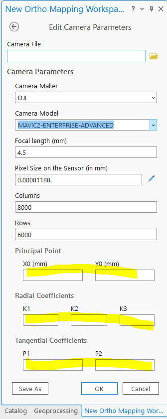
When we create the initial workspace there are warnings that this camera is not in the camera database, and there are several blank parameters (see image). At this stage I'm trying to determine if this is what's causing the block adjustment to fail
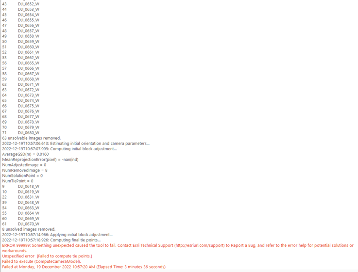
By ignoring these values, I've been able to create a workspace and then use the Adjust tool, however the block adjustment process either fails when it tries to create the tie-in points, or keeps dropping unsolvable images as per the images below. I've tried running the adjust tool without any of the camera calibration options turned on, but this didn't have any impact on the results
The operator tells me that this data was captured with only a 30% overlap - not sure if this is impacting the workflow.
I've been following this workflow https://pro.arcgis.com/en/pro-app/latest/help/data/imagery/create-an-ortho-mapping-workspace-from-dr...
any help is greatly appreciated
- Mark as New
- Bookmark
- Subscribe
- Mute
- Subscribe to RSS Feed
- Permalink
- Report Inappropriate Content
Experienced a similar case in Drone2Map today where a cameramodel is relatively well defined in the 2022.1 version but way off in the 2.3 version (which my client used). Bundle Adjustment result is good in 2002.1 and very poor in 2.3 (so poor it would be better if processing stopped).
Very poor initial cameramodel is probably a "systematic error" and not in accordance with least squares (bundle adjustment) assumptions
- Mark as New
- Bookmark
- Subscribe
- Mute
- Subscribe to RSS Feed
- Permalink
- Report Inappropriate Content
Possible good enough initial values here: https://community.pix4d.com/t/mavic-2-enterprise-advanced/18817/12#:~:text=MAVIC2%2DENTERPRISE%2DADV...
- Mark as New
- Bookmark
- Subscribe
- Mute
- Subscribe to RSS Feed
- Permalink
- Report Inappropriate Content
thankyou @Pål_Herman_Sund that's a good link.
Interestingly when I look at the properties of some individual photos, I get different values for the focal length and pixel size:
photo properties:
pixel size (mm) = 0.00072167 (calculated from 35mm equivalent focal length = 24)
focal length = 4
ArcGIS Pro settings (auto populated):
pixel size (mm) = 0.00081188
focal length = 4.5
Pix4D community settings:
pixel size (unknown units) = 0.820313
focal length = 4.5
I'll dig deeper and see if I can get any further