- Home
- :
- All Communities
- :
- Industries
- :
- Imagery and Remote Sensing Insights (IRIS) COP
- :
- Imagery Questions
- :
- Raster values or pixel location
- Subscribe to RSS Feed
- Mark Topic as New
- Mark Topic as Read
- Float this Topic for Current User
- Bookmark
- Subscribe
- Mute
- Printer Friendly Page
Raster values or pixel location
- Mark as New
- Bookmark
- Subscribe
- Mute
- Subscribe to RSS Feed
- Permalink
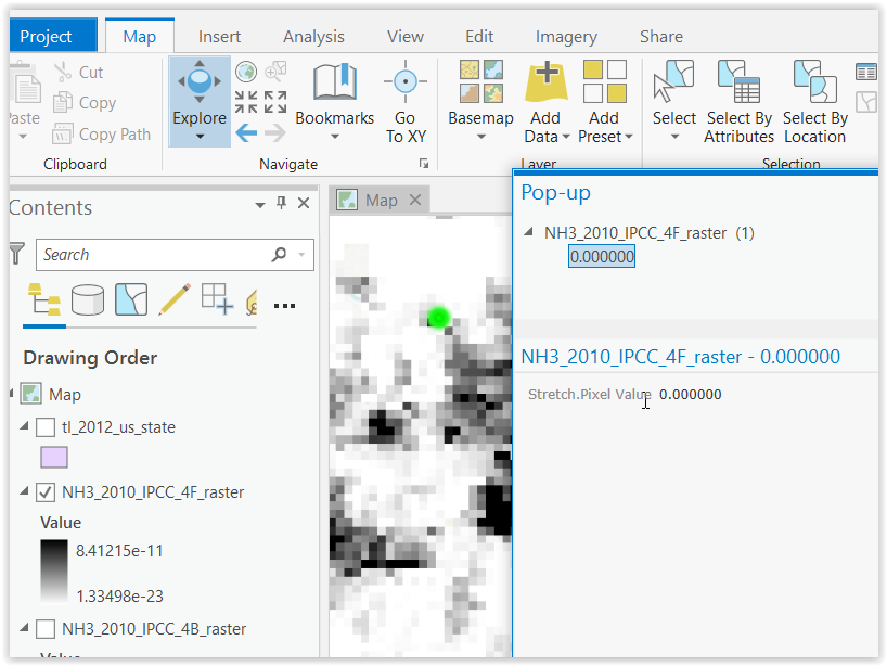
Silly question... I'd like to be able to use the ArcGIS Pro GUI to select raster pixels and see their x,y location and full values. My raster has values ranging from 10^-12 to 10^-8, so the pop-up attribute information just shows me 0.000000. I suppose if I could get the x,y location, I could use python GetCellValue to see the actual values.
A few additional notes that may be relevant:
- In my ArcGIS Pro (v 2.4), I do not see the Raster Item Explorer in my Raster Layer "Data" toolbar.
- This raster is one I've created from a .nc file via python, using arcpy.MakeNetCDFRasterLayer_md and arcpy.CopyRaster_management.
- I suppose I could use python to do some raster algebra and multiply everything by, e.g. 1e6, but that will be cumbersome when I need to go back to original data for sharing.
Thanks in advance for any help!
- Mark as New
- Bookmark
- Subscribe
- Mute
- Subscribe to RSS Feed
- Permalink
The Explore tool, on the map tab, works like the identify tool, when you click on the map. This will pop up a window that shows the pixel value and the location you clicked.
The Raster Item Explorer is only for mosaic datasets. If you have a mosaic dataset, the icon will appear on the Image Server layer tab.
Let us know if these answer your questions.
Simon W
- Mark as New
- Bookmark
- Subscribe
- Mute
- Subscribe to RSS Feed
- Permalink
Hi Simon: Thanks for the suggestion. The Explore tool is not quite behaving as you describe. I poked around a bit but don't see a setting to tweak, so I apologize if I'm missing something. Currently, the pop-up does not show x,y location, but does show the cell value (however, it's still as 0.000000, though the value is something < 10^-6).

- Mark as New
- Bookmark
- Subscribe
- Mute
- Subscribe to RSS Feed
- Permalink
Hi Andrew,
You can locate x,y location at the bottom of the above window, as shown in the below screen capture
Product Engineer at Esri
AI for Imagery
Connect with me on LinkedIn!
Contact Esri Support Services
- Mark as New
- Bookmark
- Subscribe
- Mute
- Subscribe to RSS Feed
- Permalink
Hi,
i have the same problem.
when I click with the Explore on a raster I get the pixel value but not the coordinates of the point where I clicked on the raster (I can’t see the coordinates that you marked in red above).