- Home
- :
- All Communities
- :
- Industries
- :
- Imagery and Remote Sensing Insights (IRIS) COP
- :
- Imagery Questions
- :
- How do I use a mosaic dataset as an elevation surf...
- Subscribe to RSS Feed
- Mark Topic as New
- Mark Topic as Read
- Float this Topic for Current User
- Bookmark
- Subscribe
- Mute
- Printer Friendly Page
How do I use a mosaic dataset as an elevation surface in ArcGIS Pro?
- Mark as New
- Bookmark
- Subscribe
- Mute
- Subscribe to RSS Feed
- Permalink
Hello all,
I'm trying to use a mosaic dataset as an elevation surface in ArcGIS Pro, but it doesn't seem to work. The layers that I drape on this elevation surface just appear flat. Does anyone have any hints for this?
Many thanks,
David
Solved! Go to Solution.
Accepted Solutions
- Mark as New
- Bookmark
- Subscribe
- Mute
- Subscribe to RSS Feed
- Permalink
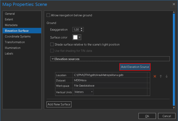
I just followed the steps but not added a new surface, but added an Elevation Source to the default "Ground" definition and removed the reference to the default surface service:
Before (less detail):
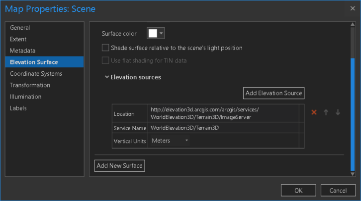

After adding my mosaic data source (more detail):


- Mark as New
- Bookmark
- Subscribe
- Mute
- Subscribe to RSS Feed
- Permalink
David -
Yes, you can use a Mosaic Dataset as an elevation surface in Pro. A couple things...
- In the Scene properties, click Elevation Surface and Add a New Surface -> your MDS.
- Remove the Esri Elevation Service by clicking the red X next to it in the first Elevation Sources and Click OK.
- In your 2D and 3D layers, go to the layer properties of each and select Elevation. For Features are: select "On a Custom Elevation Surface and select your Mosaic Dataset.
- Your 2D and 3D features should no loner be flat as it were.
- With this being said, my MDS is still flat as well so I just turned it off and used the Basemaps in 3D.
Hope this helps!
Regards,
Robert
- Mark as New
- Bookmark
- Subscribe
- Mute
- Subscribe to RSS Feed
- Permalink
Hi Robert,
Thanks for the instructions. Unfortunately, I followed all of those steps already and I got the same result as you – a flat MDS! I’m working on an offshore dataset, so I can’t revert to the basemaps for use, and the data was specifically acquired to provide elevation (or rather depths) so I would like to use them if possible.
Thanks,
David
- Mark as New
- Bookmark
- Subscribe
- Mute
- Subscribe to RSS Feed
- Permalink
I'll do some more digging around and get back to you...hopefully I can find a solution for you.
- Mark as New
- Bookmark
- Subscribe
- Mute
- Subscribe to RSS Feed
- Permalink
Thanks Robert, that would be really great
- Mark as New
- Bookmark
- Subscribe
- Mute
- Subscribe to RSS Feed
- Permalink
I just followed the steps but not added a new surface, but added an Elevation Source to the default "Ground" definition and removed the reference to the default surface service:
Before (less detail):
After adding my mosaic data source (more detail):
- Mark as New
- Bookmark
- Subscribe
- Mute
- Subscribe to RSS Feed
- Permalink
Robert, Xander, thanks for the responses. I tried this again this morning, I followed the steps again and this time it worked!
Best regards,
David
- Mark as New
- Bookmark
- Subscribe
- Mute
- Subscribe to RSS Feed
- Permalink
Glad it worked!